Sallertaine
Sallertaine | |
|---|---|
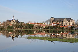 The two churches in Sallertaine | |
show Location of Sallertaine | |
 Sallertaine | |
| Coordinates: 46°51′38″N 1°57′21″W / 46.8606°N 1.9558°WCoordinates: 46°51′38″N 1°57′21″W / 46.8606°N 1.9558°W | |
| Country | France |
| Region | Pays de la Loire |
| Department | Vendée |
| Arrondissement | Les Sables-d'Olonne |
| Canton | Challans |
| Government | |
| • Mayor (2020–2026) | Jean-Luc Menuet[1] |
| Area 1 | 49.45 km2 (19.09 sq mi) |
| Population (Jan. 2018)[2] | 3,129 |
| • Density | 63/km2 (160/sq mi) |
| Time zone | UTC+01:00 (CET) |
| • Summer (DST) | UTC+02:00 (CEST) |
| INSEE/Postal code | 85280 /85300 |
| Elevation | 0–18 m (0–59 ft) |
| 1 French Land Register data, which excludes lakes, ponds, glaciers > 1 km2 (0.386 sq mi or 247 acres) and river estuaries. | |


Sallertaine (French pronunciation: [salɛʁtɛn]) is a commune in the Vendée department in the Pays de la Loire region in western France.
Apart from the two historical churches, the village is well known as an arts and crafts community due to the number of independent craftsmen and women who occupy various outlets, often in former homes, during the summer months. These range from potters and painters to jewellers and purveyors of fine, local foods. There is also a bread making museum that uses multi-lingual audio-commentary to illustrate how French artisan bakers make their famous products. It is possible for visitors to try their hand at bread making. On several evenings during the summer the village has live entertainment attracting French and foreign visitors. The village is also a centre for canoe hire from where the local salt marshes can be explored, including guided tours.
See also[]
References[]
- ^ "Répertoire national des élus: les maires". data.gouv.fr, Plateforme ouverte des données publiques françaises (in French). 2 December 2020.
- ^ "Populations légales 2018". INSEE. 28 December 2020.
| Wikimedia Commons has media related to Sallertaine. |
This Vendée geographical article is a stub. You can help Wikipedia by . |
- Communes of Vendée
- Vendée geography stubs