Choisy-le-Roi
Choisy-le-Roi | |
|---|---|
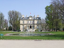 The town hall of Choisy-le-Roi | |
 Coat of arms | |
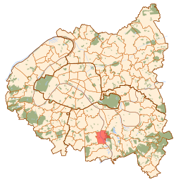 Paris and inner ring departments | |
show Location of Choisy-le-Roi | |
 Choisy-le-Roi Paris and inner ring departments | |
| Coordinates: 48°45′47″N 2°24′32″E / 48.763°N 2.409°ECoordinates: 48°45′47″N 2°24′32″E / 48.763°N 2.409°E | |
| Country | France |
| Region | Île-de-France |
| Department | Val-de-Marne |
| Arrondissement | L'Haÿ-les-Roses |
| Canton | Choisy-le-Roi |
| Intercommunality | Grand Paris |
| Government | |
| • Mayor (2020–2026) | Tonino Panetta[1] |
| Area 1 | 5.43 km2 (2.10 sq mi) |
| Population (Jan. 2018)[2] | 46,154 |
| • Density | 8,500/km2 (22,000/sq mi) |
| Time zone | UTC+01:00 (CET) |
| • Summer (DST) | UTC+02:00 (CEST) |
| INSEE/Postal code | 94022 /94600 |
| Elevation | 31–49 m (102–161 ft) (avg. 40 m or 130 ft) |
| 1 French Land Register data, which excludes lakes, ponds, glaciers > 1 km2 (0.386 sq mi or 247 acres) and river estuaries. | |


Choisy-le-Roi (French pronunciation: [ʃwazi lə ʁwa] (![]() listen)) is a commune in the Val-de-Marne department in the southeastern suburbs of Paris, France.
listen)) is a commune in the Val-de-Marne department in the southeastern suburbs of Paris, France.
Geography[]
Choisy-le-Roi is located 10.7 km (6.6 mi) southeast from the center of Paris, on both banks of the river Seine. The neighbouring communes are, from the north and clockwise: Vitry-sur-Seine, Alfortville, Créteil, Valenton, Villeneuve-Saint-Georges, Orly and Thiais.
Population[]
|
| ||||||||||||||||||||||||||||||||||||||||||||||||||||||||||||||||||||||||||||||||||||||||||||||||||||||||||||||||||
| Source: EHESS[3] and INSEE (1968-2017)[4] | |||||||||||||||||||||||||||||||||||||||||||||||||||||||||||||||||||||||||||||||||||||||||||||||||||||||||||||||||||
Transport[]
Choisy-le-Roi is served by Choisy-le-Roi station on Paris RER line C. It is also served by Créteil-Pompadour station on Paris RER line D.
Education[]
Public schools include:[5]
- Preschools (maternelles): Marcel Cachin, Danièle Casanova, Eugénie Cotton, du Centre – Auguste Blanqui, du Parc – Armand Noblet, Victor Hugo, Paul Langevin, Henri Wallon
- Elementary schools: Marcel Cachin, Jean Macé, du Centre – Auguste Blanqui, du Parc- Armand Noblet, Victor Hugo, Joliot Curie, Paul Langevin, Nelson Mandela
- Junior high schools (collèges): Emile Zola,[6] Jules Vallès,[7] Henri Matisse, College Paul Klee
.[8]
There is a private school serving elementary to senior high school, .[11]
Personalities[]
- Louise Bourgeois, artist
- Philippe Di Folco, writer
- Yves Pires, artist
- Zainoul Bah, basketball player
- Davy Dona, karateka
- Jeremy Nzeulie, basketball player
- Madimoussa Traore, footballer
- Suzanne Chaisemartin (1921–2017) organist was born in Choisy-le-Roy
International relations[]
Choisy-le-Roi is twinned with:[12]
 Đống Đa (Hanoi), Vietnam
 Hennigsdorf, Germany
 Lugo, Italy
 Târnova, Romania
See also[]
- Communes of the Val-de-Marne department
References[]
- ^ "Répertoire national des élus: les maires". data.gouv.fr, Plateforme ouverte des données publiques françaises (in French). 2 December 2020. Retrieved 7 December 2020.
- ^ "Populations légales 2018". INSEE. 28 December 2020.
- ^ Des villages de Cassini aux communes d'aujourd'hui: Commune data sheet Choisy-le-Roi, EHESS. (in French)
- ^ Population en historique depuis 1968, INSEE
- ^ "Les établissements scolaires." Choisy-le-Roi. Retrieved on September 10, 2016.
- ^ Home page. Collège Emile Zola. Retrieved on September 10, 2016.
- ^ Collège Jules Vallès." Ministry of Education of France. Retrieved on September 10, 2016.
- ^ Home. Collège Henri Matisse. Collège Paul Klee Retrieved on September 10, 2016.
- ^ Home Archived 2016-09-14 at the Wayback Machine. . Retrieved on September 10, 2016.
- ^ Home. . Retrieved on September 10, 2016.
- ^ Home. . Retrieved on September 10, 2016.
- ^ "Les jumelages". choisyleroi.fr (in French). Choisy-le-Roi. Retrieved 2019-11-20.
External links[]
| Wikimedia Commons has media related to Choisy-le-Roi. |
- City Council of Choisy-le-Roi website (in French)
- City Council of Choisy-le-Roi website (in French) (Archive)
| show Authority control |
|---|
Categories:
- Communes of Val-de-Marne