Neuilly-sur-Marne
Neuilly-sur-Marne | |
|---|---|
 The town hall of Neuilly-sur-Marne | |
 Coat of arms | |
 Paris and inner ring departments | |
show Location of Neuilly-sur-Marne | |
 Neuilly-sur-Marne Paris and inner ring departments | |
| Coordinates: 48°51′13″N 2°32′56″E / 48.853733°N 2.549027°ECoordinates: 48°51′13″N 2°32′56″E / 48.853733°N 2.549027°E | |
| Country | France |
| Region | Île-de-France |
| Department | Seine-Saint-Denis |
| Arrondissement | Le Raincy |
| Canton | Gagny |
| Intercommunality | Grand Paris |
| Government | |
| • Mayor (2020–2026) | Zartoshte Bakhtiari |
| Area 1 | 6.86 km2 (2.65 sq mi) |
| Population (Jan. 2018)[1] | 35,680 |
| • Density | 5,200/km2 (13,000/sq mi) |
| Time zone | UTC+01:00 (CET) |
| • Summer (DST) | UTC+02:00 (CEST) |
| INSEE/Postal code | 93050 /93330 |
| Elevation | 36–80 m (118–262 ft) |
| 1 French Land Register data, which excludes lakes, ponds, glaciers > 1 km2 (0.386 sq mi or 247 acres) and river estuaries. | |


Neuilly-sur-Marne (French pronunciation: [nœji syʁ maʁn] (![]() listen), literally Neuilly on Marne) is a commune in the eastern suburbs of Paris, France. It is located 13.1 km (8.1 mi) from the center of Paris.
listen), literally Neuilly on Marne) is a commune in the eastern suburbs of Paris, France. It is located 13.1 km (8.1 mi) from the center of Paris.
Geography[]
Crossed by the river Marne.
History[]
On 13 April 1892, a third of the territory of Neuilly-sur-Marne was detached and became the commune of Neuilly-Plaisance.
|
| ||||||||||||||||||||||||||||||||||||||||||||||||||||||||||||||||||||||||||||||||||||||||||||||||||||||||||||||||||
| Source: EHESS[2] and INSEE (1968-2017)[3] | |||||||||||||||||||||||||||||||||||||||||||||||||||||||||||||||||||||||||||||||||||||||||||||||||||||||||||||||||||
Transport[]
Neuilly-sur-Marne is served by no station of the Paris Métro, RER, or suburban rail network. The closest station to Neuilly-sur-Marne is Neuilly-Plaisance station on Paris RER line A. This station is located in the neighboring commune of Neuilly-Plaisance, 1.3 km (0.81 mi) from the town center of Neuilly-sur-Marne.
Education[]
Schools in the commune:[4]
- 12 preschools/nursery schools (maternelles):
- 10 elementary schools
- Junior high schools (collèges): Georges Braque, Albert Camus, and Honoré de Balzac
- 1 Senior high school/sixth-form college : Lycée Cugnot
Senior high schools/sixth-form colleges in the surrounding area include:
- Lycée Georges Clemenceau - Villemomble[5]
- Lycée Gustave Eiffel - Gagny[6]
- Lycée Evariste Galois - Noisy-le-Grand[7]
Monuments[]
Personalities[]
- Evens Joseph, footballer
- Sylvain Wiltord, footballer
- William Vainqueur, footballer
Heraldry[]
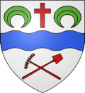 |
the arms of Neuilly-sur-Marne are blazoned : Argent, a fess wavy azure between in chief a Latin cross gules and 2 crescents inverted vert, and in base a rake and a shovel in saltire gules.
|
See also[]
- Communes of the Seine-Saint-Denis department
References[]
- ^ "Populations légales 2018". INSEE. 28 December 2020.
- ^ Des villages de Cassini aux communes d'aujourd'hui: Commune data sheet Neuilly-sur-Marne, EHESS. (in French)
- ^ Population en historique depuis 1968, INSEE
- ^ "Établissements scolaires." Neuilly-sur-Marne. Retrieved on September 8, 2016. (notice there are two pages!) - The senior highs/sixth-form colleges (lycées) are not in the city limits
- ^ "Lycée Georges Clémenceau." Neuilly-sur-Marne. Retrieved on September 8, 2016.
- ^ "Lycée Gustave Eiffel." Neuilly-sur-Marne. Retrieved on September 8, 2016.
- ^ "Lycée Evariste Galois." Neuilly-sur-Marne. Retrieved on September 8, 2016.
External links[]
| Wikimedia Commons has media related to Neuilly-sur-Marne. |
- Official website (in French)
| show Authority control |
|---|
This Seine-Saint-Denis geographical article is a stub. You can help Wikipedia by . |
- Communes of Seine-Saint-Denis
- Île-de-France geography stubs