Christophe Colomb Avenue
This article does not cite any sources. (November 2012) |
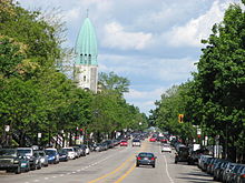 Christophe Colomb Avenue, seen northbound, with the tower of Église St-Arsène. | |||
| Native name | avenue Christophe-Colomb (French) | ||
|---|---|---|---|
| Length | 8.5 km (5.3 mi) | ||
| Location | Montreal | ||
| South end | Rachel Street | ||
| North end | Gouin Boulevard | ||
| Construction | |||
| Inauguration | 1897 | ||
Christophe Colomb Avenue (officially in French: avenue Christophe-Colomb) is a major north-south street in Montreal, Quebec, Canada. It has a length of 8.5 kilometres (5.3 miles), and crosses the boroughs of Le Plateau-Mont-Royal, Rosemont-La Petite-Patrie, Villeray-Saint-Michel-Parc-Extension and Ahuntsic-Cartierville. The street is predominantly residential south of and is a large urban boulevard to the north.
The street was named after Christopher Columbus on December 20, 1897.
Christophe Colomb Avenue begins at Rachel Street, near Lafontaine Park in the south. It is an extension of Parc Lafontaine Street. It is interrupted by Sir Wilfrid Laurier Park between Laurier Avenue and Saint Grégoire Street for distance of 400 metres. In the north, the street ends at Gouin Boulevard, near and the Rivière des Prairies.
Points of interest[]
- La Fontaine Park
- Sir Wilfrid Laurier Park
- Église Saint-Arsène
- , sports and recreation centre
- Complexe sportif Claude-Robillard
Coordinates: 45°32′43″N 73°36′58″W / 45.5453°N 73.616°W

This Montreal-related article is a stub. You can help Wikipedia by . |
This Quebec road, road transport or highway-related article is a stub. You can help Wikipedia by . |
- Streets in Montreal
- Le Plateau-Mont-Royal
- Rosemont–La Petite-Patrie
- Villeray–Saint-Michel–Parc-Extension
- Ahuntsic-Cartierville
- Montreal stubs
- Quebec road stubs