Chuniespoort
This article needs additional citations for verification. (November 2009) |
Chuniespoort | |
|---|---|
 Chuniespoort | |
| Coordinates: 24°13′45″S 29°29′48″E / 24.22917°S 29.49667°ECoordinates: 24°13′45″S 29°29′48″E / 24.22917°S 29.49667°E | |
| Country | South Africa |
| Province | Limpopo |
| District | Capricorn |
| Municipality | Polokwane |
| Area | |
| • Total | 1.91 km2 (0.74 sq mi) |
| Population (2011)[1] | |
| • Total | 1,271 |
| • Density | 670/km2 (1,700/sq mi) |
| Racial makeup (2011) | |
| • Black African | 100.0% |
| First languages (2011) | |
| • Northern Sotho | 92.5% |
| • Tsonga | 4.6% |
| • Zulu | 1.0% |
| • Other | 1.8% |
| Time zone | UTC+2 (SAST) |
| Postal code (street) | 0745 |
| PO box | 0745 |
| Area code | 015 |


Chuniespoort (recently Chuenespoort[2]) is a mountain pass situated in the Limpopo Province, on the R37, the road between Polokwane and Lebowakgomo, South Africa. The river flowing through this gorge of the is known as the , one of the tributaries of the Olifants River.[3]
Etymology[]
The pass is named for an African leader, whose name would be spelled Tshwene in modern Northern Sotho orthography.[2]
References[]
- ^ a b c d "Main Place Chuniespoort". Census 2011.
- ^ a b Jenkins, Elwyn (2007), Falling into place: the story of modern South African place names, David Philip Publishers, p. 75
- ^ "Environmental Management Framework for the Olifants and Letaba Rivers Catchment area" (PDF). Archived from the original (PDF) on 2013-12-27. Retrieved 2012-04-10.
Municipalities and communities of Capricorn District Municipality, Limpopo | ||
|---|---|---|
District seat: Polokwane | ||
| Blouberg | 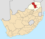 | |
| Molemole | ||
| Polokwane | ||
| Lepelle-Nkumpi | ||
This Limpopo location article is a stub. You can help Wikipedia by . |
Categories:
- Mountain passes of South Africa
- Populated places in the Polokwane Local Municipality
- Mountain passes of Limpopo
- Limpopo geography stubs