Cibyra


Cibyra or Kibyra (Greek: Κιβύρα), also referred to as Cibyra Magna, is an Ancient Greek city and an archaeological site in south-west Turkey, near the modern town of Gölhisar, in Burdur Province. It was the chief city of a district known as Cibyratis.
Location[]
Ancient literary sources are not totally clear on Cibyra's location, [1][2] but the site is identified by inscriptions on the spot.
The elevation of the Cibyratic plain is estimated to be 3500 feet above the level of the sea. It produces corn. The sites of Balbura, Bubon, and Oenoanda, which is on the Xanthus, being now ascertained, we can form a tolerably correct idea of the extent of the Cibyratis. It comprised the highest part of the basin of the Xanthus, and all the upper and probably the middle part of the basin of the Indus, for Strabo describes the Cibyratis as reaching to the Rhodian Peraea. The great range of Cadmus (Baba Dagh), said to be 8000 feet high, bounded it on the west, and separated it from Caria. The upper part of the basin of the Indus consists of numerous small valleys, each of which has its little stream. Pliny's brief description[3] has been derived from good materials: the river Indus, which rises in the hills of the Cibyratae, receives sixty perennial rivers, and more than a hundred torrents.[2]
History[]
According to Strabo, the Cibyratae (Ancient Greek: Κιβυρᾶται) were said to be descendants of Lydians, who once occupied the , but also of the neighboring Pisidians.[2] The city grew powerful in the second century BC, and its territory extended from Pisidia and the adjoining Milyas to Lycia and the Peraea of the Rhodians. At this time it joined with three neighbouring towns, Bubon, Balubura, and Oenoanda, to form a confederation called the Tetrapolis. Within this confederation, the other three cities had one vote, but Cibyra had two votes, since it could muster 30,000 infantry and 2000 cavalry.
Cibyra is first mentioned by Livy[4] in his account of Ganaeus Manlius Vulso's operations in 189 BC during the Galatian War. Manlius approached Cibyra from the upper part of the Maeander river valley and through Caria. He probably advanced upon it by the valley of Karaook, through which a road led from Cibyra to Laodicea on the Lycus. Manlius demanded and got from Moagetes I, the tyrant of Cibyra, 100 talents and 10,000 medimni of wheat. Livy says that Moagetes controlled Syleum and Alimne, in addition to Cibyra. William Smith suggested that Alimne could be identified with the remains of a large town on an island in lake Gölhisar (east of modern Gölhisar), which were connected to the mainland by an ancient causeway.
Following the Treaty of Apamea in 188 BC, Cibyra became part of the Attalid Kingdom.[5] In 133 BC, the last Attalid king, Attalus III left his kingdom to the Roman Republic, which reconstituted it as the province of Asia. It is not clear whether Cibyra formed part of the new province or was granted its freedom.[6]
In 83 BC, during the First Mithridatic War, the Roman general Lucius Licinius Murena deposed the last tyrant of Cibyra, Moagetes II, who was the son of one Pancrates,[7][2] and dissolved the Tetrapolis. Balbura and Bubon were assigned to the Lycian League.
Writing at the beginning of the first century AD, Strabo says that the Cibyratae spoke four languages: Pisidian, , Greek, and Lydian.[8] This makes Cibyra the last locality where the Lydian language, by then extinct in Lydia itself according to extant accounts, is attested.[9]
Under the empire, the city had also the name Caesarea, as indicated by an inscription referring to "The Council and People of the Caesarean Cibyrites" (Καισαρεων Κιβυρατων ἡ βουλη και ὁ δημος) and by the legend "Caesareans" (Καισαρεων), which appears on some of the coins of Cibyra.[2] Cibyra was the centre of a conventus (an assize district), which contained twenty-five cities, according to Pliny the Elder. Laodicea on the Lycus was one of the chief cities of this Conventus.
Cibyra was heavily damaged by an earthquake in the time of Tiberius, who recommended a Senatus Consultum be enacted relieving it from payment of taxes (tributum) for three years.[10] In the passage discussing these events, Tacitus calls it the civitas Cibyratica apud Asiam (Cibyatic community in Asia.[2]
The poet Horace mentions Cibyra as a place of great trade[11] William Smith notes that its position does not seem very favourable for commerce, since it is neither on the sea nor on a great road, and suggests that the city might have exported grain of the Indus valley and the wool and iron of Cibyra might. Iron ore was plentiful in the Cibyratis. It was a peculiarity of Cibyra that the iron was easily cut with a chisel, or other sharp tool.[12][2]
We know nothing of any artists of Cibyra, except two, whom Cicero claims were more famous for their knavery than for their artistic skill.[13]
Archaeological remains[]
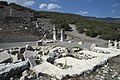
The ruins cover the crest of a hill between 300 and 400 feet above the level of the plain. The material for the buildings was gotten from the limestone in the neighbourhood; and many of them are in good condition. One of the chief buildings is a theatre, in fine preservation: the diameter is 266 feet. The seats command a view of the Cibyratic plain, and of the mountains towards the Milyas. On the platform near the theatre are the ruins of several large buildings supposed to be temples, some of the Doric and others of the Corinthian order. A large building about 100 yards from the theatre is supposed to have been an Odeum or music theatre. There are no traces of city walls.[2]
Stadium[]
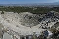
The stadium, 650 feet in length and 80 in breadth, is at the lower extremity of the ridge on which the city stands. The hill side was partly excavated to make room for it; and on the side formed out of the slope of the hill were ranged 21 rows of seats, which at the upper extremity of the stadium turned so as to make a theatre-like termination. This part of the stadium is very perfect, but the seats on the hill side are much displaced by the shrubs that have grown up between them. The seats overlook the plain of Cibyra. The seats on the side opposite to the hill were marble blocks placed on a low wall built along the edge of the terrace, formed by cutting the side of the hill. Near the entrance to the stadium a ridge runs eastward, crowned by a paved way, bordered on each side by sarcophagi and sepulchral monuments. At the entrance to this avenue of tombs was a massive triumphal arch of Doric architecture, now in ruins.[2]
Kibyra Stadium end

Kibyra Stadium General view

Kibyra Stadium

Kibyra Stadium from curved part

Kibyra Stadium view high side


Inscriptions[]
The inscriptions from the site are collected in IK Kibyra, volume 60 of the series.[14] That corpus contains 448 Greek and Latin inscriptions, ranging in date from the second century BC to Late Antiquity.
Statues[]
In 2019, archaeologists found a bust of Serapis and a statue of Asclepius.[15] In the 2020 excavation season, another statue of Asclepius and the head of a bust of Serapis were found in Kibyra, date back to 2nd century A.D.[16]
Graves[]
In 2021, archaeologists found 30 graves in a basilica church. The researchers believe that many of them belonged to the important clergy of the city.[17]
Gallery[]
Kibyra Theatre from top

Kibyra Theatre from stage part

Kibyra Temple

Kibyra Odeon from the outside

Kibyra Odeon inside
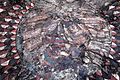
Medusa mosaic of Kibyra

Kibyra Odeon Roman bath

Kibyra Odeon Roman bath

Kibyra Agora Frieze

Kibyra Roman bath


References[]
- ^ Strabo does not fix the position of Cibyra precisely. After mentioning Antiochia on the Maeander as being in Caria, he says, to the south the great Cibyra, Sinda, and the Cabalis, as far as Taurus and Lycia. Ptolemy v. 3. places Cibyra in Great Phrygia, and assigns the three cities of Bubon, Balbura, and Oenoanda to the Cabalis of Lycia, which is consistent with Strabo. Pliny also considered it part of the region of Phrygia.
- ^ a b c d e f g h i
 One or more of the preceding sentences incorporates text from a publication now in the public domain: Smith, William, ed. (1854–1857). "Cibyra". Dictionary of Greek and Roman Geography. London: John Murray.
- ^ v. 28.
- ^ xxxviii. 14.
- ^ Otto Mørkholm (31 May 1991). Early Hellenistic Coinage from the Accession of Alexander to the Peace of Apamaea (336-188 BC). Cambridge University Press. pp. 9–10. ISBN 978-0-521-39504-5.
- ^ Morstein-Marx, Robert (1995). Hegemony to empire : the development of the Roman Imperium in the East from 148 to 62 B.C. Berkeley: University of California Press. pp. 113–114. ISBN 9780585160382.
- ^ Polybius xxx. 9.
- ^ Strabo, Geography, § 13.4.17
- ^ N.P. Milner (1998). An Epigraphical Survey in the Kibyra-Olbasa Region conducted by A S Hall (Monograph). British Institute of Archaeology at Ankara.
- ^ Tacitus Annales 4.13
- ^ Horace Ep. i. 6. 33
- ^ see Groskurd's Note, Transl. Strab. vol. ii. p. 633, where he unnecessarily make a distinction between τορεύεσθαι and τορνεύεσθαι).
- ^ Verr. ii. 4. c. 13
- ^ Corsten, Thomas (2002). Die Inschriften von Kibyra. Bonn: Habelt. ISBN 9783774930346.
- ^ "Significant Roman-era artifacts found in Kibyra". Hürriyet Daily News. 25 November 2020.
- ^ "Statuette of Asklepios, bust of Serapis found in Kibyra". Hürriyet Daily News. 7 January 2021.
- ^ "Graves found in basilica-planned ancient city". Hürriyet Daily News. 2 April 2021.
Bibliography[]
- Berns, Christof; Ali Ekinci, H. (2015). "Gladiatorial games in the Greek East: a complex of reliefs from Cibyra". Anatolian Studies. 65: 143–179.
- Corsten, T. (2002). Die Inschriften von Kibyra. Bonn.
- Erkelenz, D. (1998). "Zur Provinzzugehorigkeit Kibyras in der romischen Kaiserzeit". Epigraphica Anatolica. 30: 81–95.
- Japp, Sarah (2009). "The local pottery production of Kibyra". Anatolian Studies. 59: 95–128.
- Milner, N. P. (1998). An epigraphical survey in the Kibyra-Olbasa region conducted by A.S. Hall. London: British Institute of Archaeology at Ankara. ISBN 9781912090624.
External links[]
| Wikimedia Commons has media related to Kibyra. |
| Aegean Region |
|
|---|---|
| Black Sea Region |
|
| Central Anatolia Region |
|
| Eastern Anatolia Region |
|
| Marmara Region |
|
| Mediterranean Region |
|
| Southeastern Anatolia Region |
|
| Country-wide |
|
| |
Coordinates: 37°09′36″N 29°29′21″E / 37.1601°N 29.4892°E
Authority control | |
|---|---|
| General |
|
| National libraries | |
- Populated places in ancient Lydia
- Archaeological sites in the Mediterranean Region, Turkey
- Burdur
- History of Burdur Province
- Gölhisar District
- Catholic titular sees in Asia
- World Heritage Tentative List for Turkey
- Ancient Greek archaeological sites in Turkey