Üsküdar
This article needs additional citations for verification. (April 2007) |
Üsküdar
Üsküdar Belediyesi | |
|---|---|
| Municipality of Üsküdar | |
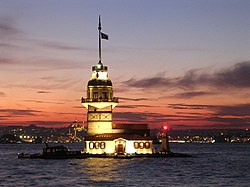 Maiden's Tower (Kız Kulesi) off the coast of Üsküdar in Istanbul | |
 | |
 Üsküdar | |
| Coordinates (Municipal Building): 41°1′26.36″N 29°0′59.48″E / 41.0239889°N 29.0165222°E | |
| Country | Turkey |
| Province | Istanbul Province |
| Made a municipality of Istanbul | 1984 |
| Neighborhoods | show
List |
| Government | |
| • Mayor | Hilmi Türkmen (AKP) |
| Area | |
| • District | 46.41 km2 (17.92 sq mi) |
| Population (2018)2 | |
| • District | 529,145 |
| • District density | 11,000/km2 (30,000/sq mi) |
| Website | uskudar |

Üsküdar (Turkish pronunciation: [ysˈcydaɾ]), traditionally known in Italian and English as Scutari (Skoutàrion, Σκουτάριον in Greek), and in classical antiquity known as Chrysopolis (Greek: Χρυσόπολις, 'Golden City'), is a large and densely populated district and municipality of Istanbul, Turkey, on the Anatolian shore of the Bosphorus. It is bordered on the north by Beykoz, on the east by Ümraniye, on the southeast by Ataşehir, on the south by Kadıköy, and on the west by the Bosphorus, with the areas of Beşiktaş, Beyoğlu, and Eminönü on the opposite shore. It is home to about half a million people. Üsküdar is also the usual name for the historic center of the municipality.
Etymology[]
Üsküdar was originally called Skoutarion (Byzantine Greek: Σκουτάριον) during the Byzantine Empire. This word may have been used to describe the scutum shields that guards used that were made of leather. This is believed because the word scutari means 'raw tanned leather'. Invading Persians, Macedonians, Arabs, and Crusaders called the city Eksüdar or Escutaire.[2]
History[]
Chrysopolis[]
Üsküdar was founded in the 7th century BC by ancient Greek colonists from Megara as Chrysopolis (Greek: Χρυσόπολις, 'Golden City'), a few decades before Byzantium was founded on the opposite shore.[3] According to an ancient Greek geographer, the city received the name Chrysopolis because the Persian empire had a gold depository there or because it was associated with Agamemnon and Chryseis' son, Chryses.[4] On the other hand, according to an 18th-century writer, it received the name because of the excellence of its harbor.[5] The city was used as a harbor and shipyard and was an important staging post in the wars between the Greeks and Persians. In 410 BC Chrysopolis was taken by the Athenian general Alcibiades, and the Athenians used it thenceforth to charge a toll on ships coming from and going to the Black Sea.[4] Long overshadowed by its neighbor Chalcedon during the Hellenistic and Roman period, it maintained its identity and increased its prosperity until it surpassed Chalcedon.[3] Due to its less favorable location with respect to the currents of the Bosporus, however, it never surpassed Byzantium.[3]
In AD 324, the final battle between Constantine I, Emperor of the West, and Licinius, Emperor of the East, in which Constantine defeated Licinius, took place at Chrysopolis.[3] When Constantine made Byzantium his capital, Chrysopolis, together with Chalcedon, became suburbs.[3] Chrysopolis remained important throughout the Byzantine period because all trade routes to Asia started there, and all Byzantine army units headed to Asia mustered there.[3] During the brief usurpation of the Armenian general Artabasdos, his eldest son, Niketas, was defeated with his forces at Chrysopolis by the army of Constantine V, before Artabasdos was finally deposed by the legitimate emperor Constantine and blinded. For this reason, and because of its location across from Constantinople, it was a natural target for anyone aiming at the capital.[3] Also, in the 8th century AD it was taken by a small band of Arabs, who caused considerable destruction and panic in Constantinople, before withdrawing.[3] In 988, a rebellion that nearly toppled Basil II began in Chrysopolis, before he was able to crush with the aid of Russian mercenaries.[3]
Skoutarion, Scutari[]
In the 12th century, the city changed its name to Skoutarion (Greek: Σκουτάριον), the name deriving from the Emperor's Skoutarion Palace nearby.[3] In 1338 the Ottoman leader Orhan Gazi took Skoutarion, giving the Ottomans a base within sight of Constantinople for the first time.[3]
In the Ottoman period Üsküdar was one of the three communities outside the city walls of Constantinople (along with Eyüp and Galata). The area was a major burial ground, and today many large cemeteries remain, including Karacaahmet Mezarlığı, Bülbülderesi Mezarlığı, and a number of Jewish and Christian cemeteries. Karacaahmet Mezarlığı is one of Istanbul's largest cemeteries. The Bülbülderesi cemetery is next to Fevziye Hatun mosque.[6]
The neighborhood suffered during the ethnic-religious violence of the 6 September 1955, Istanbul pogrom. Turkish rioters looted Greek and Armenian Christian shops and raped Greek and Armenian Christian women, and many Greeks and Armenians subsequently fled the country.[7][8][9]
Üsküdar today[]
This section needs to be updated. (January 2019) |

The district of Üsküdar is one of Istanbul's oldest-established residential areas. It is directly opposite the old city of Eminönü and transport across the Bosphorus is easy by boat or bridge. So there are well-established communities here, many retired people, and many residents commute to the European side for work or school (being cheap and central Üsküdar has a large student population). During the rush-hour, the waterfront is bustling with people running from ferryboats and motorboats onto buses and minibuses. Üsküdar also has the smell of the sea, the sound of foghorns, motorboats and seagulls and one of the best views of the city.

As of 2006, the central square is being dug up for a tunnel under the Bosphorus which will carry an underground railway. However, this is predictably continuously running into artifacts of great archaeological value.
The area behind the ferry dock is a busy shopping district, with many restaurants (including the well-known Kanaat Lokantası serving Ottoman cuisine, olive oil-based dishes, and ice cream) and a number of important Ottoman mosques (see section below). However, there are relatively few cafes, cinemas, billiard halls, and places for youth to congregate.[citation needed]
The private Üsküdar University, founded by the Human Values and Mental Health Foundation, has a campus here.
Uskudar has two public libraries: Şemsi Pasha Mosque Public Library (built in 1953) and Selimiye Public Library.
Neighborhoods[]

Üsküdar is a municipality within borders of Istanbul Metropolitan Municipality (büyükşehir). The municipality is subdivided into neighborhoods (mahalleler). The boundaries and names of the official neighborhoods change from time to time and sometimes do not correspond to historically recognized neighborhoods or to residents' own perceptions.
The most prominent neighborhood is Üsküdar's historic center (merkez), centered on the ferry docks and roughly corresponding to the current Mimar Sinan neighborhood (former Selmanağa, Tembel Hacı Mehmet, and İnkılap neighborhoods). This area includes large historic mosques, many businesses and markets, and is a transportation hub.
Other prominent neighborhoods include the former villages on the Bosphorus to the north of the historic center, Kuzguncuk, Beylerbeyi, Çengelköy, Kuleli, Vaniköy (now part of Kandilli), and Kandilli; the neighborhoods along the Bosphorus shore south of the historic center, Salacak, Harem (now part of Aziz Mahmud Hudayı), and Selimiye; and the mostly residential neighborhoods on the hilltops and hillsides, Doğancılar (now mostly part of Aziz Mahmud Hudayı), İmrahor (now part of Salacak), Selamsız (now part of Selamiali), Bağlarbaşı (now part of Altunizade), Altunizade, Acıbadem, Küçük Çamlıca, and Büyük Çamlıca (mostly in Kısıklı, Burhaniye, and Ferah).
Salacak[]

Üsküdar's long promenade along the coast from the center down in southern direction towards the bus station at Harem is popular in summer as it commands views of the European shore of Topkapı Palace, Aya Sofya, Sultan Ahmed Mosque (The Blue Mosque), Taksim and Beşiktaş. This promenade is lined with cafes and restaurants, the most prominent of which is not on the coast but out in the water: the Maiden's Tower (Kız Kulesi), a small tower just off the coast that has existed since Byzantine times, when it was called Leander's Tower. From time to time it has been used as a toll booth; now it is used as an upscale restaurant and a venue for wedding parties. The name comes from a legend about a princess shut in the tower.[citation needed]
On nice days people gather on the shore to fish, sit and drink tea or to enjoy being out on the water in little rowing boats. There is a more recent mosque (1760) on the shore opposite the tower. The streets of Salacak behind the coast, in the area called Imrahor, are attractive and still hold a number of classic Ottoman wooden houses. The legendary 17th-century Hezarfen Ahmet Çelebi is said to have landed here on his hang-glider flight across the Bosphorus.[citation needed]
Further down along the coast is the Harem neighborhood, which contains a major intercity bus terminal and the Selimiye Barracks, where Florence Nightingale once tended wounded British soldiers.[10] Behind the coast, towards the east, Üsküdar climbs steeply into the residential areas uphill, Bağlarbaşı and Doğancılar.
Doğancılar[]
A pleasant neighborhood on the hill above Salacak, with plenty of trees between the buildings and a small park. There is a wide avenue winding uphill from Üsküdar, which has plenty of shops and cafes, and also a theater (the Musahipzade Celal Sahnesi), the fire station, the former women's prison (Paşakapısı Prison), Burhan Felek High School and Doğancılar mosque (opposite the park).
Bağlarbaşı and Altunizade[]

Formerly orchards and fruit-gardens (bağ), it became a residential neighborhood in the 19th century, home to the typical Istanbul urban mix of Greeks, Jews, Turks, and Armenians.[citation needed] The neighborhood still has an Armenian school and the Armenian church of Surp Garabed, built in 1844. Until the 1990s the area remained a middle-class residential neighborhood,[citation needed] and today is still an attractive district with a mixture of housing and office/commercial property. A number of properties have been converted to office and business use. Altunizade is still an attractive residential neighborhood, home to the large and busy Capitol shopping and entertainment center. Altunizade was established in the early 19th century by . He also commissioned Altunizade Mosque, which was built in 1866.
There are a number of well-known schools within the district including Üsküdar American Academy, one of the oldest established schools in the city, Üsküdar High School, a state school, Haydarpasha High School, Marmara University's faculty of theology; and Burhan Felek sports complex.
Selamsız[]

Selamsız is an old residential neighborhood, home to a Roma (Gypsy) community and Roma culture.[citation needed]
Acıbadem[]
The top half of the attractive district of Acıbadem also belongs to Üsküdar, including Acıbadem and Academic hospitals. This avenue with its patisseries, ice-cream parlors and cafés, is the center one of the most pleasant neighborhoods of Istanbul,[citation needed] consisting of tree-lined streets and well-planned housing areas, as well as Çamlıca Girls’ High School set in a tree-lined garden.[citation needed]
Up the Bosphorus[]
The boundary of the municipality of Üsküdar is far up the Bosphorus, and beyond lies Beykoz. Üsküdar's up-north Bosphorus villages include:
Paşalimanı[]
Just past Üsküdar the coastline is called Paşalimanı. Liman means "port" in Turkish (from Greek limàni, λιμάνι) and boats would moor here. A large stone building on the shore, built as a tobacco warehouse by late-Ottoman architect Vedat Tek, has been completely renovated and now serves as headquarters of Ciner Grubu (Ciner Group), an industrial conglomerate. There is a small area of parkland right on the shore and the entrance to the large Fetih Paşa Korusu park is here.
Kuzguncuk[]


A Bosphorus village of streets with little shops, seaside cafes, and many old-fashioned wooden houses, Kuzguncuk has a village atmosphere. There is a ferry dock and a little park on the waterfront. The village was called Kosinitsa in the Byzantine period and until recently the people of Kuzguncuk were the typical Istanbul cosmopolitan mixture of Turks, Greeks, Jews, and Armenians.[citation needed] There are very few non-Muslims left today and the area has become an attractive middle-class neighborhood, home to people like film director Uğur Yücel, sculptor Kuzgun Acar, painter (whose studio is in the village), architects Nevzat Sayin and Cengiz Bektaş, and the late poet Can Yücel. The neighborhood is also portrayed in the novel Mediterranean Waltz (Kumral Ada Mavi Tuna) by Buket Uzuner.
Beylerbeyi[]

Just beyond the Bosphorus bridge is Beylerbeyi, an area known in Istanbul for its fish restaurants, and for the Ottoman palace on the shore. The Sabancı family of Turkish industrialists have sponsored the restoration and building of the school, police station and other public buildings, thus making them appropriate to the many very attractive houses and shops in the village.
Çengelköy[]
Formerly a waterfront village, known for the cucumbers grown in gardens on the green hillsides behind. There are a number of very grand seaside villas (yalı). The village has a number of shops, bakeries and waterfront cafes offering gorgeous views of the Bosphorus that tend to be busy, especially at weekends. Since the mid-1990s new housing estates have been built on the hillsides and now there are always queues of traffic through Çengelköy. But the village retains some of its romantic charm. The word çengel means "hook" or "anchor" in Turkish, and köy means "village"; apparently there were blacksmiths or metalworkers in the village in Ottoman times.[citation needed]
The highly prestigious Kuleli Military High School is on the Bosphorus just beyond Çengelköy. Most graduates from here go on to military academy and careers as army officers.
Inland from the center of Üsküdar[]
Çamlıca[]
This hill, known as Tchamlidja in 19th-century spelling, has the highest point in Istanbul and commands a panoramic view of the entire city. One of the most prestiged schools of Turkey, Bilfen College is located on the Çamlıca hill.
Climate[]
Üsküdar experiences a Humid subtropical climate (Cfa/Cf) according to both Köppen and Trewartha climate classifications, with cool winters and warm to hot summers. Unlike most of southern Istanbul, Üsküdar is cooler than its surroundings, with an average temperature slightly below 14 °C (57 °F), and an AHS heat zone rating of 3.[11] However, its coastal location still does allow it to be classified as USDA hardiness zone 9a.[11]
| hideClimate data for Kandilli, Istanbul | |||||||||||||
|---|---|---|---|---|---|---|---|---|---|---|---|---|---|
| Month | Jan | Feb | Mar | Apr | May | Jun | Jul | Aug | Sep | Oct | Nov | Dec | Year |
| Average high °C (°F) | 7.9 (46.2) |
8.0 (46.4) |
10.4 (50.7) |
15.5 (59.9) |
20.2 (68.4) |
24.9 (76.8) |
27.1 (80.8) |
27.0 (80.6) |
23.8 (74.8) |
19.0 (66.2) |
14.6 (58.3) |
10.5 (50.9) |
17.4 (63.3) |
| Daily mean °C (°F) | 5.2 (41.4) |
5.1 (41.2) |
7.0 (44.6) |
11.3 (52.3) |
15.8 (60.4) |
20.2 (68.4) |
22.7 (72.9) |
22.8 (73.0) |
19.6 (67.3) |
15.4 (59.7) |
11.3 (52.3) |
7.8 (46.0) |
13.7 (56.6) |
| Average low °C (°F) | 2.4 (36.3) |
2.2 (36.0) |
3.5 (38.3) |
7.1 (44.8) |
11.3 (52.3) |
15.4 (59.7) |
18.2 (64.8) |
18.5 (65.3) |
15.3 (59.5) |
11.7 (53.1) |
8.0 (46.4) |
5.0 (41.0) |
9.9 (49.8) |
| Average precipitation mm (inches) | 103 (4.1) |
83 (3.3) |
69 (2.7) |
45 (1.8) |
37 (1.5) |
36 (1.4) |
32 (1.3) |
39 (1.5) |
69 (2.7) |
96 (3.8) |
101 (4.0) |
128 (5.0) |
838 (33.1) |
| Source: [12][13] | |||||||||||||
Sights of Üsküdar[]
Though densely populated, Üsküdar has many areas of greenery, including the Çamlıca hills, the Bosphorus coastline, and various parks. In addition, the area has a high concentration of historic buildings and religious sites.
Parks[]
Fethi Paşa Korusu is a large park on the hillside that extends down to the Bosphorus shore, slightly beyond Üsküdar in the area called Paşalimanı. It is named after an Ottoman prince who among other things was responsible for industrializing the glassworks of Ottoman Turkey, and had a home in the area. The parkland is in fact privately owned and let to the state on condition that it is preserved as a park. The owners are the estate of Turkish industrialist Nuri Demirağ. There is a café in the park, a stone waterfall which children climb on and a small stage area where on Friday evenings in summer a band of amateur musicians give open-air concerts at sunset. At weekends the young lovers of Üsküdar gather here to stroll and cuddle in the shade.[14]
Mosques[]

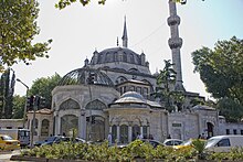
Üsküdar is home to over 180 mosques,[15] many of them historic Ottoman buildings, many built for women of the imperial harem, and many built by the architect Mimar Sinan. Among the first things one sees on arriving by ferry are the two mosques on either side of the ferry port, both designed by Sinan. The larger one is the Mihrimah Sultan Mosque, sometimes called the İskele (Dock) Mosque, built by a daughter of Suleiman the Magnificent; the smaller one is the Şemsi Pasha Mosque, built by a vizier of Suleiman's. Şemsi Pasha has a small library building in the courtyard where one can sit and enjoy the sea breeze off the Bosphorus.
A little further inland between the fountain of Ahmet III and the Şemsi Pasha Mosque is the large Yeni Valide Mosque, built by Ahmet III's mother. Uphill from the dock in the Valideiatik neighborhood is the Atik Valide Mosque, built by Murat III's mother and also designed by Sinan. Further uphill from there is the smaller . In Karacaahmet Cemetery is the large Şakirin Mosque, built in 2009.
The (built in 1860) in the eastern part of Üsküdar, close to the border with Ümraniye, is one of the few historical wooden mosques in Istanbul.
Other important mosques of Üsküdar include Ahmediye, Ahmet Ağa, Ahmet Çelebi, Altunizade, Ayazma, Aziz Mahmut Hudai, Baki Efendi, Beylerbeyi, Bodrumi Ömer Lütfi Efendi, Bostancı, Bulgurlu, Çakırcıbaşı, Fatih, Gülfem Hatun, Hacı Ömer, İmrahor, İranlılar, İstavroz, Kandilli, Kara Davut Pasha, Kaymak Mustafa Pasha, Kısıklı, Küleli Bahçe, Malatyalı İsmail Ağa, Mirzazade, Paşalimanı, Rum Mehmet Pasha, Selimiye, Solak Sinan, Tahır Efendi, Üryanizade, and Vanikoy.
Churches[]

Churches of Üsküdar include the İlya Profiti (Prophet Elijah) Greek Orthodox Church in Muratreis (present building built in 1831), the Kandilli Khristos Rum Ortodoks Kilisesi (built in 1810), the Surp Garabet (Saint John the Baptist) Armenian Church in Murat Reis (first church on the site, 1590; present building built 1888), the Surp Haç (Holy Cross) Armenian Church in Selami Ali (built 1676, rebuilt 1880), the Surp Krikor Lusavoriç (Saint Gregory the Illuminator) Armenian Church in Kuzguncuk (first built 1835, rebuilt 1861), and the Surp Yergodasan Arakelots (Twelve Apostoles) Armenian Church in Kandilli (built 1846).[16][17]
Synagogues[]
Synagogues of Üsküdar include Bet Yaakov (built 1878) and Bet Nissim (built in the 1840s).[18]
Other religious buildings[]
Important tekkes (dervish lodges) include the Aziz Mahmud Hudayi Tekke (Aziz Mahmud Hudayi (1541–1628), who is buried in Üsküdar and was the founder of the Jelveti Sufi order);[19] the Nasuhi Efendi Tekke (Nasuhi Efendi was the founder of the Nasuhiyye Khalwati Sufi order[20] and the grandfather of the Turkish-American music producer Ahmet Ertegun); and the famous Özbekler Tekkesi,[21] where the Ertegun family members are buried.
Important tombs in Üsküdar include those of Aziz Mahmud Hudayi, , Halil Pasha, İbrahim Edhem Pasha, , and .
The Karacaahmet Cemetery, the largest cemetery in Istanbul and one of the oldest, has many notable burials.
Çeşmes and sebils[]

Other notable Ottoman features to be seen in Üsküdar are the many çeşmes (drinking water sources) and sebils (kiosks for distribution of drinks). One of the largest and most visible çeşmes is the fountain of Ahmet III (1728–29), an impressive marble structure in the center of Üsküdar near the ferry docks.
Other important çeşmes of Üsküdar include Gülnuş Emetullah Valide Sultan (1709, next to the Yeni Valide Mosque), Hüseyin Avni Pasha (1874, Paşalimanı), Mustafa III (1760, next to the Ayazma Mosque), and Selim III (1802, in Çiçekçi, Harem İskelesi Street).[22]
Important sebils of Üsküdar include those of Hacı Hüseyin Pasha (1865, near the Karacaahmet Cemetery), Halil Pasha (1617, attached to Halil Pasha's tomb), Hudayi (first built in the 1590s but later much remodeled, near Aziz Mahmud Hudayi's tomb), Sadettin Efendi (1741, near the tomb of Karacaahmet Cemetery), Şeyhülislam Arif Hikmet Bey (1858, near the Kartal Baba Mosque), Valide Çinili (1640, next to the Çinili Mosque), Valide-i Cedid (1709, next to the Yeni Valide Mosque), and Ziya Bey (1866, near the tomb of Karacaahmet).[23]
Museums[]

The inside the Selimiye Barracks in Selimiye displays items associated with Nightingale and her medical work in Istanbul during the Crimean War.[24] The Beylerbeyi Palace Museum in Beylerbeyi shows the palace built for Abdülaziz in the 1860s.
Education[]
- Üsküdar American Academy (formerly American Academy for Girls)
- Tarabya British Schools has its Çengelköy campus there.[25]
- Üsküdar University
Twin towns[]
Twin municipalities[]
Notable residents[]
- Richard Guyon (1813–1856), British-born Hungarian soldier, general in the Hungarian revolutionary army
- Maximus the Confessor – Byzantine monk, theologian and scholar. He entered a monastery in Chrysopolis in the early 7th century.[29]
- Philippicus - Byzantine general; a monk in Chrysopolis between 602–610, and buried in Chrysopolis.[30]
- Sergius I of Constantinople - Ecumenical Patriarch of Constantinople.[31]
- Patriarch Pyrrhus of Constantinople - Ecumenical Patriarch of Constantinople.[32]
- Alexios Mosele - Byzantine aristocrat and general[33]
- Michael III - Byzantine emperor
- Florence Nightingale - English nurse, writer and statistician
- Mehmet Akif Ersoy - Turkish poet of the Turkish national anthem
- Halide Edip Adıvar - Turkish novelist and feminist political leader
- Xenophon Sideridis - Greek historian, writer and researcher
- Şeker Ahmed Pasha – Turkish painter
- Mehmed Orhan – Turkish aristocrat, a pretender to the throne of the Ottoman Dynasty
- – Turkish legal counsel in international law to the Ottoman Empire and diplomat of Turkey
- Ahmet Ertegun – Turkish-American musician and businessman, and founder and president of Atlantic Records and New York Cosmos soccer team
- Nesuhi Ertegun – Turkish-American record producer and executive of Atlantic Records and WEA International
- Barış Manço – Turkish rock singer, composer, and television producer
- Bülent Ersoy – transgender Turkish celebrity and singer of Ottoman classical music
- Özgü Namal – Turkish actress
- Semahat Özdenses (1913–2008) – Turkish singer and composer of Ottoman classical music
- Hasan Çelebi – world-renown master Islamic calligrapher
- Kadir Mısıroğlu (1933-2019) – conservative writer and amateur historian
- Zabel Sibil Asadour – Armenian poet and writer
- Calouste Gulbenkian – Armenian businessman and philanthropist, once the richest man in the world
- Garabet Yazmaciyan – Armenian painter
- – Armenian writer
- Gabriel Noradunkyan – Ottoman Armenian politician
- Yeghishe Tourian – Armenian Patriarch of Jerusalem and Constantinople
- Bedros Tourian – Armenian poet
- Hovhannes Hintliyan – Armenian pedagogue and educator
- Hrand Nazariantz – Armenian poet and writer
- Levon Shant – Armenian poet, writer, and playwright
- Sirvart Kalpakyan Karamanuk – Armenian composer, pianist, and teacher
- Schahan Berberian – Armenian philosopher, composer, and pedagogue
- Srpuhi Kalfayan – Armenian nun and philanthropist
- Zabel Yesayan – Armenian poet, writer, and teacher
References[]
- ^ "Area of regions (including lakes), km²". Regional Statistics Database. Turkish Statistical Institute. 2002. Retrieved 5 March 2013.
- ^ Mosque and Street, Scutari, Constantinople, Turkey. World Digital Library. 1890–1900. Retrieved 18 October 2013.
- ^ Jump up to: a b c d e f g h i j k Taylor, Jane (13 October 1998). Imperial Istanbul: A Traveler's Guide. Palgrave Macmillan. ISBN 9781860642494. Retrieved 16 May 2018 – via Google Books.
- ^ Jump up to: a b William Smith.Dictionary of Greek and Roman Geography — "Chryso'polis" 1854.
- ^ François Sabbathier (1772). Dictionnaire pour l'intelligence des auteurs classiques, grecs et latins: tants sacrés que profanes, contenant la géographie, l'histoire, la fable, et les antiquités. 11. p. 135.
- ^ Soner Yalçın. Efendi.
- ^ Vryonis, Speros (1 January 2005). The Mechanism of Catastrophe: The Turkish Pogrom of September 6–7, 1955, and the Destruction of the Greek Community of Istanbul. Greekworks.com. greekworks.com. ISBN 978-0-9747660-3-4. Retrieved 16 May 2018 – via Internet Archive.
- ^ Mills, Amy (2010). Streets of Memory: Landscape, Tolerance, and National Identity in Istanbul. The University of Georgia Press. ISBN 9780820335735.
- ^ Pamuk, Orhan (2005). Istanbul: Memories and the City. Alfred A. Knopf. ISBN 9781524732233.
- ^ Cypresses and Road Leading to the Cemetery, Scutari, Constantinople, Turkey. World Digital Library. 1890–1900. Retrieved 18 October 2013.
- ^ Jump up to: a b "Bitki Soğuğa ve Sıcağa Dayanıklılık". www.mgm.gov.tr. Retrieved 28 April 2021.
- ^ "Üsküdar - Weather History & Climate Data - Meteostat". meteostat.net. Retrieved 3 June 2021.
- ^ Toros, Hüseyin; Abbasnia, Mohsen; Sagdic, Mustafa; Tayanç, Mete (19 November 2017). "Long-Term Variations of Temperature and Precipitation in the Megacity of Istanbul for the Development of Adaptation Strategies to Climate Change". Advances in Meteorology. Retrieved 3 June 2021.
- ^ Uskudara Gideriken instrumental Rabab Music of Turkish Song, retrieved 12 June 2020
- ^ "Archived copy". Archived from the original on 8 October 2011. Retrieved 10 August 2009.CS1 maint: archived copy as title (link)
- ^ Üsküdar Belediyesi. Kiliseler. "Archived copy". Archived from the original on 6 October 2011. Retrieved 22 November 2009.CS1 maint: archived copy as title (link) Retrieved 14 August 2009
- ^ Tuğlacı, pages 121–129, 169–171, 194.
- ^ "Alan Adına Ait Varsayılan Sayfa". Musevicemaati.com. Retrieved 16 May 2018.
- ^ "AZİZ MAHMUD HÜDÂYÎ - TDV İslâm Ansiklopedisi". islamansiklopedisi.org.tr. Retrieved 17 November 2020.
- ^ "NASÛHÎ TEKKESİ - TDV İslâm Ansiklopedisi". islamansiklopedisi.org.tr. Retrieved 17 November 2020.
- ^ "ÖZBEKLER TEKKESİ - TDV İslâm Ansiklopedisi". islamansiklopedisi.org.tr. Retrieved 17 November 2020.
- ^ "Archived copy". Archived from the original on 28 February 2007. Retrieved 10 August 2009.CS1 maint: archived copy as title (link)
- ^ "Archived copy". Archived from the original on 30 August 2009. Retrieved 10 August 2009.CS1 maint: archived copy as title (link)
- ^ Chisholm, Hugh, ed. (1911). . Encyclopædia Britannica. 24 (11th ed.). Cambridge University Press. p. 518.
- ^ "Contact Us". Tarabya British Schools. Retrieved 9 July 2019.
- ^ Komuna e Sarajit binjakëzim me komunën turke Uskudar Archived 4 June 2012 at the Wayback Machine, INA, 1 June 2012 (in Albanian)
- ^ "Brooklyn-Üsküdar: Istanbul and New York's iconic districts join forces". Dailysabah.com. Retrieved 16 May 2018.
- ^ "友好都市との交流" (in Japanese). 渋谷区. Retrieved 28 May 2021.
- ^ Kurian, George Thomas (2010). The Encyclopedia of Christian Literature. Scarecrow Press. p. 454. ISBN 978-0-8108-6987-5.
- ^ Whitby, Michael (1988). The Emperor Maurice and his Historian – Theophylact Simocatta on Persian and Balkan Warfare. Oxford University Press. p. 129. ISBN 0-19-822945-3.
- ^ Bischoff, Bernhard (1994). Biblical commentaries from the Canterbury school of Theodore and Hadrian. Cambridge University Press. p. 59. ISBN 0-521-33089-0.
- ^ Bathrellos, Demetrios (2004). The Byzantine Christ: person, nature, and will in the Christology of Saint Maximus the Confessor. Oxford University Press. p. 65. ISBN 0-19-925864-3.
- ^ Skylitzes, John (2010). A Synopsis of Byzantine History, 811-1057. Cambridge University Press. p. 66. ISBN 978-0-521-76705-7.
Bibliography[]
| Wikimedia Commons has media related to Üsküdar. |
- Adım Adım İstanbul İnanç Atlası: Camiler, Türbeler, Ziyaret Yerleri, Mezarlıklar. Mapmedya. 2004. ISBN 975-6206-02-0.
- Hürel, Haldun (2008). Semtleri, Mahalleri, Caddeleri ve Sokakları A'dan Z'ye İstanbul'un Alfabetik Öyküsü. İkarus. ISBN 978-975-999-290-3.
- Kumbaracılar, İzzet (2008). İstanbul Sebilleri. Kapı. ISBN 978-9944-486-87-3. (First published 1938)
- Tuğlacı, Pars (1991). İstanbul Ermeni Kiliseleri = Armenian Churches of Istanbul = Istʻanpuli Hayotsʻ ekeghetsʻinerě. Pars. ISBN 975-7423-00-9.
| show Üsküdar in Istanbul Province of Turkey |
|---|

| show |
|---|
| show Authority control |
|---|
- Üsküdar
- Bosphorus
- Populated places in Istanbul Province
- Districts of Istanbul Province
- Transit centers in Istanbul
- Megarian colonies in Thrace
- Populated places of the Byzantine Empire
- Istanbul pogrom