Karaman Province
This article needs additional citations for verification. (May 2011) |
Karaman Province
Karaman ili | |
|---|---|
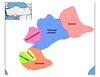
 Location of Karaman Province in Turkey | |
| Country | Turkey |
| Region | West Anatolia |
| Subregion | Konya |
| Government | |
| • Electoral district | Karaman |
| • Governor | Mehmet Alpaslan Işık |
| Area | |
| • Total | 9,163 km2 (3,538 sq mi) |
| Population (2018)[1] | |
| • Total | 251,913 |
| • Density | 27/km2 (71/sq mi) |
| Area code(s) | 0338 |
| Vehicle registration | 70 |
Karaman Province (Turkish: Karaman ili) is a province of south-central Turkey. It has an area of 9,163 km2. It has a population of 232,633 (2010 est). According to the 2000 census the population was 243,210. Population density is 27.54 people/km2. The traffic code is 70. The capital is the city of Karaman. Karaman was the location of the Karamanid Beylik, which came to an end in 1486.
Districts[]
Karaman province is divided into 6 districts (capital district in bold):
Towns[]
Place of interest[]
- Binbirkilise, a region around Karadağ Mountain 30 km (19 mi) north of Karaman with Byzantine church ruins.
See also[]
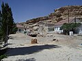
- Görmeli, a village on the hillside of the Taurus Mountains near Ermenek
- Karadağ Mountain, an extinct volcano north of Karaman city
- List of populated places in Karaman Province
Gallery[]

Görmeli, a village in Ermenek district
Akpınar village in Ayrancı district

View of Ala Bridge near Ermenek


References[]
- ^ "Population of provinces by years - 2000-2018". Turkish Statistical Institute. Retrieved 9 March 2019.
External links[]
| Wikimedia Commons has media related to Karaman Province. |
- (in Turkish) Karaman governor's official website
- (in Turkish) Karaman municipality's official website
- (in English) Karaman weather forecast information
Coordinates: 37°01′23″N 33°05′39″E / 37.02306°N 33.09417°E

See also[]
| show Authority control |
|---|
This geographical article about a location in Karaman Province, Turkey is a stub. You can help Wikipedia by . |
Categories:
- Karaman Province
- Central Anatolia Region geography stubs