Mersin Province
This article needs additional citations for verification. (January 2017) |
Mersin Province
Mersin ili | |
|---|---|
Province of Turkey | |
 Location of Mersin Province in Turkey | |
| Country | Turkey |
| Region | Mediterranean |
| Subregion | Adana |
| Government | |
| • Electoral district | Mersin |
| Area | |
| • Total | 15,853 km2 (6,121 sq mi) |
| Population (2018)[1] | |
| • Total | 1,814,468 |
| • Density | 110/km2 (300/sq mi) |
| Area code(s) | 0324 |
| Vehicle registration | 33 |
Mersin Province (Turkish: Mersin ili), formerly İçel Province (Turkish: İçel ili), is a province in southern Turkey, on the Mediterranean coast between Antalya and Adana. The provincial capital and the biggest city in the province is Mersin, which is composed of Akdeniz, Mezitli, Toroslar and Yenişehir metropolitan municipalities, followed by Tarsus, the birthplace of Paul the Apostle. The province is considered to be a part of the geographical, economical and cultural region of Çukurova, which covers the provinces of Mersin, Adana, Osmaniye and Hatay.
Etymology[]
The province is named after its biggest city Mersin. Mersin was named after the aromatic plant genus Myrsine (Greek: Μυρσίνη, Turkish: mersin) in the family Primulaceae, a myrtle that grows in abundance in the area. The 17th-century Ottoman traveler Evliya Çelebi has recorded in his Seyahatnâme that there was also a clan named Mersinoğulları in the area.[2]
Geography[]
87% of the land area is mountain, leading up to the rocky heights of the central Taurus Mountains, the highest peak is Medetsiz (3,584 m) in the Bolkar range, and there are a number of important passes over to central Anatolia. There are many high meadows and small plains between 700 and 1500m.
The coastal strip has many large areas of flatland, formed from soil brought down by rivers and streams running off the mountains. This is fertile land, the largest area being the plain of Tarsus. The largest rivers are the Göksu and the Berdan (aka Tarsus, Cydnus of antiquity), but there are many small streams running into lakes, reservoirs or the Mediterranean sea. Mersin has 321 km of coastline, much of it sandy beach. The climate is typical of the Mediterranean; very hot and very humid in summer, warm and wet in winter; the winter rains can be very heavy and flooding is a problem in many areas, but it never snows on the coast, although there is snow in the mountainous areas.
History[]
In antiquity, this coast was part of Cilicia, named for a Phoenician or Assyrian prince that had settled here. Trade from Syria and Mesopotamia over the mountains to central Anatolia passed through here, through the Cilician Gates. The geographer Strabo, described the region as being divided into "Rugged Cilicia" (Cilicia Trachea, Κιλικία Τραχεία in Greek) and "Flat Cilicia" (Cilicia Pedias, Κιλικία Πεδιάς). The capital of both sections of Cilicia was Tarsus and Mersin was its seaport.
Administration[]
As of 1933, there were two separate provinces, namely İçel and Mersin, on the territory of today's Mersin Province. When the Mersin Province was abolished and merged with the İçel Province, the seat of the latter was moved from Silifke to Mersin. In 2002, the province's name was changed from İçel to Mersin but the province retained the license plate number of 33, İçel having been the 33rd in the alphabetical order of Turkish province names.
Districts[]

Mersin province is divided into thirteen districts four of which are actually included within the municipality of Mersin city (shown in boldface letters).
- Akdeniz
- Anamur
- Aydıncık
- Bozyazı
- Çamlıyayla
- Erdemli
- Gülnar
- Mezitli
- Mut
- Silifke
- Tarsus
- Toroslar
- Yenişehir
Demographics[]
About 50% of the population of the province is younger than 24 years of age. 68% were born in Mersin. The literacy rate is 89%. About 43% of the male population and about 27% of the female population graduated from middle school. Infant mortality is 0.48%. Urban population growth rate is 2.42%. Population density is 117 as of November 2020.(In the table below, the four second-level municipalities are merged within Mersin proper.)
| Name of the district | Population (urban area) |
Population (district total, including rural area) |
|---|---|---|
| Mersin | 842,230 | 888,803 |
| Anamur | 34,227 | 62,702 |
| Aydıncık | 8,004 | 11,651 |
| Bozyazı | 15,615 | 26,295 |
| Çamlıyayla | 2,861 | 9,847 |
| Erdemli | 45,241 | 125,391 |
| Gülnar | 8,357 | 19,141 |
| Mut | 28,966 | 63,673 |
| Silifke | 51,684 | 113,404 |
| Tarsus | 233,436 | 308,681 |
Economy[]
The city of Mersin is one of busiest cities in Turkey. Due to the economic activity in this part of Turkey generated by the GAP Project Mersin is Turkey's biggest Mediterranean port, and also hosts an oil refinery and a free trade zone; there are a number of factories along the road between Mersin and Adana, manufacturing glass, detergents, fertilisers and many more. With all this activity a modern city has grown with a university and other major amenities.
Tourism[]
Mersin does not have the huge volume of tourists enjoyed by neighbouring Antalya or the Aegean coast, but Turkish people do come to this coast, especially now that the hotels have air-conditioning, and perhaps more to the mountain country behind where there are healing mineral water springs. In summer the hills are a popular retreat from the high humidity and extreme heat on the coast. West of Mersin includes bays, and little islands. Yacht touring is a tourism income in these areas.
Places of interest[]
- The city of Tarsus, birthplace of St Paul, whose house and well are sites of Christian pilgrimage.
- Silifke - ancient Seleucia Pieria, buildings include the church of Aya Tekla, the first female saint.
- The ancient Roman town of Soloi-Pompeiopolis, now within the city. About Mersin
- The ancient Roman town of Anemurium, adjacent to the modern town of Anamur.
- Another ancient city of Elaiussa Sebaste, 55 km from the city of Mersin.
- Castles including Mamure, Kızkalesi and Namrun.
Towns and other geographic features[]
Towns[]
- Arslanköy
- Ayvagediği
- Büyükeceli
- Çarıklar
- Çeşmeli
- Göksu
- Gözne
- Gülek
- Fındıkpınarı
- Kargıpınarı
- Kızkalesi
- Kocahasanlı
- Köseçobanlı
- Kuskan
- Limonlu
- Narlıkuyu
- Ören
- Sebil
- Taşucu
- Tekeli
- Tekmen
- Uzuncaburç
- Yenice
- Yeşilovacık
- Yeşiltepe
- Zeyne
Archaeological and historical[]
- Adamkayalar
- Alahan Monastery
- Altından geçme
- Akhayat sinkhole
- Aya Tekla Church
- Baç Bridge
- Bilal Habeşi Masjid
- Canbazlı ruins
- Caracalla's inscription
- Cennet and Cehennem
- Cleopatra's gate
- Corycus
- Çanakçı rock tombs
- Dörtayak
- Gözlükule
- Kanlıdivane
- Karakabaklı
- Kırkkaşık Bedesten
- Laal Pasha Mosque
- Lamas Aqueduct
- Mancınık Castle
- Mamure Castle
- Meydancık Castle
- Mezgitkale
- Mut Castle
- Olba (ancient city)
- Öküzlü ruins
- Paşa Türbesi
- Roman road in Cilicia
- Saint Paul's Church, Tarsus
- Silifke Castle
- Sinekkale
- Soli, Cilicia
- Tapureli ruins
- Tarsus Grand Mosque
- Taşgeçit Bridge
- Tekir ambarı
- Üçayaklı ruins
- Veyselli rock reliefs
- Yanıkhan
- Yumuktepe
Museums[]
- Anamur Museum
- Mersin Museum
- Mersin Atatürk Museum
- Mersin Naval Museum
- Mersin Urban History Museum
- Mersin Water Museum
- Narlıkuyu Museum
- Silifke Museum
- Silifke Atatürk Museum
- Tarsus Museum
Other[]
- 2013 Mediterranean Games
- Berdan River
- Cyprus Memorial Cemetery in Silifke
- Çukurova
- Dana Adası
- Gulf of Mersin
- Karabucak Forest
- Karakız Lake
- List of municipalities in Mersin Province
- List of populated places in Mersin Province
- Mersin Congress and Exhibition Center
- Mersin Grand Mosque
- Mersin Harbor
- Mezitli River
- Muğdat Mosque
- Müftü River
- Tourism centers of Mersin Province
- Transport in Mersin Province
- Yenice Conference (Yenice Görüşmesi )
See also[]
Gallery[]
This article contains too many pictures, charts or diagrams for its overall length. |

Mersin
Mediterranean sea shore
Mersin
Refah monument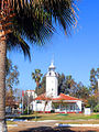
Mersin
Light house
Mersin
Harbor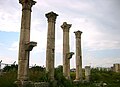
Mersin
Soli ruins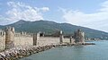
Anamur
Mamure castle
Aydıncık
Aynalıgöl
Aydıncık
Detail from the mosaic
Aydıncık
Dörtayak
Çamlıyayla
Kadıncık dam
Erdemli
Maiden's castle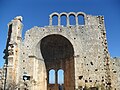
Erdemli
Öküzlü basilica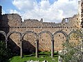
Erdemli
Emirzeli church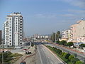
Erdemli
Lamos
Erdemli
Lake Karakız
Mut
Mut castle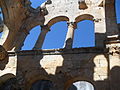
Mut
Alahan Monastery
Silifke
Silifke historical bridge
Silifke
Cape Tisan
Silifke
Boğsak Islet
Silifke
Karakabaklı ruins
Silifke
Sinekkale
Silifke
Sculpture in Silifke Museum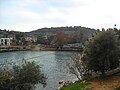
Silifke
Narlıkuyu
Silifke
Susanoğlu
Silifke
Mezgitkale
Tarsus
Berdan River
Tarsus
Cleopatra's Gate
Tarsus
Grand Mosque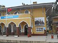
Tarsus, Yenice train station
Location of İnönü-Churcill meeting


Notes[]
- ^ "Population of provinces by years - 2000-2018". Turkish Statistical Institute. Archived from the original on 27 April 2019. Retrieved 9 March 2019.
- ^ İçel: Mersin- Tarsus- Çamlıyayla- Erdemli- Silifke- Aydıncık- Bozyazı- Anamur- Gülnar- Mut (Kültür, Turizm ve Tanıtım yayınları, 1992), p. 7.
External links[]
| Wikimedia Commons has media related to Mersin Province. |
- University of Mersin
- Real Estate Agency Mersin Turkey
- Mersin Technoscope
- Mersin Chamber of Commerce and Industry (in English)
- Mersin Chamber of Shipping (in English)
- Mersin Photographic society (in English)
- Mersin Free Zone
Coordinates: 36°40′43″N 33°48′19″E / 36.67861°N 33.80528°E

| show Mersin Province of Turkey |
|---|

| show |
|---|
| show Authority control |
|---|
- Mersin Province