Ağrı Province
Ağrı Province
Ağrı ili | |
|---|---|
 Location of Ağrı Province in Turkey | |
| Country | Turkey |
| Region | Northeast Anatolia |
| Subregion | Ağrı |
| Government | |
| • Electoral district | Ağrı |
| • Governor | Osman Varol |
| Area | |
| • Total | 11,376 km2 (4,392 sq mi) |
| Population (2018)[1] | |
| • Total | 539,657 |
| • Density | 47/km2 (120/sq mi) |
| Area code(s) | 0472 |
| Vehicle registration | 04 |
| Website | http://www.agri.gov.tr |
The Ağrı Province (Turkish: Ağrı ili, Kurdish: Parêzgeha Agiriyê[2]) is a province in eastern Turkey, bordering Iran to the east, Kars to the north, Erzurum to the northwest, Muş and Bitlis to the southwest, Van to the south, and Iğdır to the northeast. It has an area of 11,376 km² and a population of 542,022 (2010 est). The province is considered part of Western Armenia by Armenians[3] and mostly was part of ancient province of Ayrarat[4] of Kingdom of Armenia. Before the Armenian genocide, modern Ağri Province was part of the six Armenian vilayets.[5][6] The province is considered part of Turkish Kurdistan and has a Kurdish majority.[7][8]
The provincial capital is Ağrı, situated on a 1,650 metres (5,410 ft) high plateau. Doğubayazıt was the capital of the province until 1946.[9] The current governor is Süleyman Elban.[10]
Districts[]
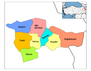
Ağrı province is divided into eight districts (capital district in bold):
Geography[]
Ağrı is named after the nearby Mount Ararat, a 5,137 metres (16,854 ft) high stratovolcano, the highest mountain in Turkey and a national symbol to Armenians (see Western Armenia). It can be climbed from here and can be seen from parts of Azerbaijan, Iran, Georgia, and Armenia. The nearest town to the mountain is Doğubayazıt.
46% of the province is mountainous, 29% is plain, 18% is plateau, and 7% high meadow. As well as Ararat there are many other peaks over 3,000m, including Aladağlar and Tendürek. The plains are fertile, being covered in volcanic deposits, and are used for growing grains and grazing. Various tributaries of the Murat River (which later feeds the Euphrates) flow through the area and water these plains. The high meadows are used for grazing.
The weather here is very cold (temperatures as low as -10°C (14°F) in winter) and the mountainsides are mainly bare. There are a number of important passes and routes through the mountains.
History[]
The plateau of Ağrı was controlled by the Kingdom of Urartu until its transition to the Kingdom of Armenia. The area was coveted by many as a gateway between east and west. It was conquered numerous times by Assyrians, Greeks, Romans, Byzantines, Arabs, Georgians, Mongols, Persians, and finally by the Seljuq and Ottoman Turks.
The first Muslims in the area were the Abbasids in 872. The Turkish tribes began to pass through in huge numbers following the defeat of the Byzantine armies at Malazgirt in 1071, sometimes pursued by Mongols. The land was brought into the Ottoman Empire by Sultan Selim I following the Battle of Chaldiran. The region was part of the Erzurum Vilayet during the Ottoman Empire.
Inspectorates-General[]
In the late 1920s, in an attempt to curb the Ararat rebellion,[11][12] the province was included into the First Inspectorate-General (Turkish: Birinci Umumi Müfettişlik)[13] comprising the provinces of Mardin, Diyarbakır, Van, Elazıĝ, Bitlis, Hakkari, Şanlıurfa and Siirt.[14]
In September 1935 the province was transferred into the third Inspectorate General (Umumi Müfettişlik, UM).[15] The third UM span over the provinces of Erzurum, Artvin, Rize, Trabzon, Kars Gümüşhane, Erzincan and Ağrı. It was governed by a Inspector General seated in the city of Erzurum.[15] [16] The Inspectorate General was dissolved in 1952 during the Government of the Democrat Party.[17]
Recent events[]
On August 19, 2006, the Tabriz–Ankara gas pipeline exploded in the province. Turkish authorities suspect Kurdish rebels were behind the incident.[18]
Ağrı today[]
The economy is mainly agricultural. People also live by breeding animals. Ağrı attracts tourists to the mountains, for climbing and trekking in summers, and skiing in winters. Places of interest include:
- Ishak Pasha Palace in Doğubayazıt
- Mount Tendürek in Doğubayazıt with what some claim to be the second-largest meteor crater in the world
- in Patnos
- The tomb of Ahmedi Hani, who wrote the Kurdish epic Mem and Zin
Demographics[]
| District | Total | Urban | Rural |
|---|---|---|---|
| Ağrı | 149,581 | 117,431 | 32,150 |
| Patnos | 120,654 | 65,530 | 55,124 |
| Doğubayazıt | 120,320 | 79,349 | 40,971 |
| Diyadin | 42,340 | 20,387 | 21,953 |
| Eleşkirt | 33,940 | 16,042 | 17,898 |
| Tutak | 30,699 | 6,741 | 23,958 |
| Taşlıçay | 20,490 | 6,129 | 14,361 |
| Hamur | 18,261 | 3,198 | 15,063 |
| Province | 536,285 | 314,807 | 221,478 |
References[]
- ^ "Population of provinces by years - 2000-2018". Turkish Statistical Institute. Retrieved 9 March 2019.
- ^ "Li Agirî û Wanê qedexe hat ragihandin" (in Kurdish). Rûdaw. 25 November 2019. Retrieved 27 April 2020.
- ^ Myhill, John (2006). Language, Religion and National Identity in Europe and the Middle East: A historical study. Amsterdam: J. Benjamins. p. 32. ISBN 978-90-272-9351-0.
- ^ "Welcome to Encyclopaedia Iranica". iranicaonline.org. Retrieved 2021-04-09.
- ^ İsmail Soysal, Türkiye'nin Siyasal Andlaşmaları, I. Cilt (1920-1945), Türk Tarih Kurumu, 1983, p. 14.
- ^ Verheij, Jelle (2012). Jongerden, Joost; Verheij, Jelle (eds.). Social Relations in Ottoman Diyarbekir, 1870–1915. Brill. p. 88. ISBN 9789004225183.
- ^ Watts, Nicole F. (2010). Activists in Office: Kurdish Politics and Protest in Turkey (Studies in Modernity and National Identity). Seattle: University of Washington Press. p. 167. ISBN 978-0-295-99050-7.
- ^ Bois, Th; Minorsky, V.; MacKenzie, D. N. (2002). "Kurds, Kurdistān". Encyclopaedia of Islam (2 ed.). BRILL. ISBN 9789004161214.
- ^ Law, Gwillim (2015-05-20). Administrative Subdivisions of Countries: A Comprehensive World Reference, 1900 through 1998. McFarland. p. 372. ISBN 978-1-4766-0447-3.
- ^ "Ağrı Valiliği". www.agri.gov.tr. Retrieved 2020-03-25.
- ^ Strohmeier, Martin (2003). Crucial Images in the Presentation of a Kurdish National Identity: Heroes and Patriots, Traitors and Foes. Brill. pp. 95–99. ISBN 978-90-04-12584-1.
- ^ Cagaptay, Soner (2006-05-02). Islam, Secularism and Nationalism in Modern Turkey: Who is a Turk?. Routledge. p. 24. ISBN 978-1-134-17448-5.
- ^ Cagaptay (2006), p.24
- ^ Bayir, Derya (2016-04-22). Minorities and Nationalism in Turkish Law. Routledge. p. 139. ISBN 978-1-317-09579-8.
- ^ Jump up to: a b "Üçüncü Umumi Müfettişliği'nin Kurulması ve III. Umumî Müfettiş Tahsin Uzer'in Bazı Önemli Faaliyetleri". Dergipark. p. 2. Retrieved 8 April 2020.
- ^ Bayir, Derya (2016-04-22). Minorities and Nationalism in Turkish Law. Routledge. pp. 139–141. ISBN 978-1-317-09579-8.
- ^ Fleet, Kate; Kunt, I. Metin; Kasaba, Reşat; Faroqhi, Suraiya (2008-04-17). The Cambridge History of Turkey. Cambridge University Press. p. 343. ISBN 978-0-521-62096-3.
- ^ "Gas pipeline explodes in Turkish rebel region". CNN. 2006-08-19. Archived from the original on 2006-08-24. Retrieved 2008-04-04.
External links[]

| show Authority control |
|---|
- Ağrı Province
- Provinces of Turkey
- Turkish Kurdistan