Konya Province
Konya Province
Konya ili | |
|---|---|
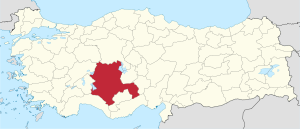 Location of Konya Province in Turkey | |
| Country | Turkey |
| Region | West Anatolia |
| Subregion | Konya |
| Government | |
| • Electoral district | Konya |
| • Governor | Vahdettin Özkan |
| Area | |
| • Total | 38,257 km2 (14,771 sq mi) |
| Population (2018)[1] | |
| • Total | 2,205,609 |
| • Density | 58/km2 (150/sq mi) |
| Area code(s) | 0332 |
| Vehicle registration | 42 |
Konya Province (Turkish: Konya ili) is a province of Turkey in southwest-central Anatolia. The provincial capital is the city of Konya. By area it is the largest province of Turkey. Its traffic code is 42.
The Kızılören solar power plant in Konya will be able to produce 22.5 megawatts of electricity in an area of 430,000 square meters.[2]
Demographics[]
In 2011 the Konya Metropolitan Municipality had a population close to 1.1 million, out of the 2 million in the Konya Province (76.2% of the population in Konya Province lives in the city, while the remainder live in the villages, sub-districts and districts.) Konya Province has 31 districts, three of which are central districts: Karatay, Meram and Selçuklu.
Language census[]
Official first language results (1927-1965[3])
| Language | 1927 | 1935 | 1945 | 1950 | 1955 | 1960 | 1965 |
|---|---|---|---|---|---|---|---|
| Turkish | 94.8% | 95.3% | 96.1% | 95.7% | 96.6% | 98.7% | 97.3% |
| Kurdish | 4.2% | 4% | 3.8% | 2.6% | 2.9% | 1.1% | 2.5% |
| Circassian | 0.4% | 0.3% | 0.1% | 0.2% | 0.2% | 0.1% | 0.1% |
| Tatar | 0.2% | 0.3% | N/A | N/A | N/A | N/A | N/A |
| Albanian | 0.1% | 0% | 0% | 0% | 0% | 0% | 0% |
| Other | 0.2% | 0.1% | 0% | 1.5% | 0.3% | 0% | 0.1% |
Divisions[]
The Konya province is divided into thirty-one districts three of which are actually included in the municipality of Konya city (shown in boldface letters).

The following districts are located in the Mediterranean Region: Ahırlı, Beyşehir, Bozkır, Derebucak, Hadim, Hüyük, Seydişehir, Taşkent, Yalıhüyük.
Caves[]
Caves in Konya Province are:[4]
- , Beyşehir
- , Derebucak
- , Beyşehir
- , Seydişehir
See also[]
- Konya Province, Ottoman Empire
Gallery[]

Mevlana Museum

Ince Minaret Medrese (1279) in Konya
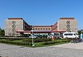
Hilton Garden Inn, Konya


Konya Büyükşehir Stadium in Konya


References[]
- ^ "Population of provinces by years - 2000-2018". Turkish Statistical Institute. Retrieved 9 March 2019.
- ^ Company opens Turkey’s ‘largest solar power plant’ in Central Anatolia
- ^ Türkiye Nüfus Sayimlarinda Azinliklar. Retrieved 16 December 2018.
- ^ "Konya Mağaraları" (in Turkish). Kültür ve Turizm Bakanlığı - Yatırım ve İşletmeler Genel Müdürlüğü. Retrieved 2017-01-26.
External links[]
| Wikimedia Commons has media related to Konya Province. |

| show Authority control |
|---|
Coordinates: 38°00′48″N 32°41′56″E / 38.01333°N 32.69889°E

This geographical article about a location in Konya Province, Turkey is a stub. You can help Wikipedia by . |
- Konya Province
- Konya Province geography stubs