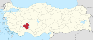
Isparta Province
This article needs additional citations for verification. (March 2018) |
Isparta Province
Isparta ili | |
|---|---|
 Location of Isparta Province in Turkey | |
| Country | Turkey |
| Region | Mediterranean |
| Subregion | Antalya |
| Government | |
| • Electoral district | Isparta |
| Area | |
| • Total | 8,993 km2 (3,472 sq mi) |
| Population (2018)[1] | |
| • Total | 441,412 |
| • Density | 49/km2 (130/sq mi) |
| Area code(s) | 0246 |
| Vehicle registration | 32 |
Isparta Province (Turkish: Isparta ili) is a province in southwestern Turkey. Its adjacent provinces are Afyon to the northwest, Burdur to the southwest, Antalya to the south, and Konya to the east. It has an area of 8,993 km2 and a population of 448,298 up from 434,771 (1990). The provincial capital is Isparta.
The province is well known for its apples, sour cherries, grapes, roses and rose products, and carpets. The best fertile lands are in the area named Uluborlu. The province is situated in the Göller Bölgesi (Lakes Area) of Turkey's Mediterranean Region and has many freshwater lakes.
Districts[]
Isparta province is divided into 13 districts (capital district in bold):
- Aksu
- Atabey
- Eğirdir
- Gelendost
- Gönen
- Isparta
- Keçiborlu
- Şarkikaraağaç
- Senirkent
- Sütçüler
- Uluborlu
- Yalvaç
- Yenişarbademli
Sites of interest[]
Kovada Lake and Kızıldağ National Parks, Isparta Gölcüğü, Çamyol and Kuyucak forest recreation areas, Eğirdir oak and Sütçüler forest conservation areas, Eğirdir, Uluborlu and Yalvaç castles, Antiochia in Pisidia and Apollonia antiquity cities, Ertokuş and Dündar Bey old theological schools (medrese), Isparta Hızır Bey, Kutlu Bey, Firdevs Bey, İplik, Eğirdir Hızır Bey, Barla Çaşnigir, Uluğbey Veli Baba mosques, Firdevs Bey Bazaar, Eğirdir Inn (caravansary), Ertokuş Hanı Inn, Baba Sultan Mousoleum, Isparta and Yalvaç Museums.
In 2020, the ancient 10 meters height rock mass of symbolic importance, which was in a village in Yalvaç district, was blown by treasure hunters.[2]
Notable people[]
Gallery[]
Köprülü Canyon in Sütçüler district

Ancient Roman inscriptions in Yalvaç

Antioch, Pisidia in Yalvaç district

Lake Eğirdir in Eğirdir district
See also[]
References[]
- ^ "Population of provinces by years - 2000-2018". Turkish Statistical Institute. Retrieved 9 March 2019.
- ^ Ancient symbolic rocks detonated by treasure hunters in Isparta
External links[]
| Wikimedia Commons has media related to Isparta Province. |
- (in Turkish) Isparta governor's official website
- (in Turkish) Isparta municipality's official website
- (in English) Isparta weather forecast information
- (in Turkish) Isparta city guide
- (Turkish) Isparta info website
Coordinates: 37°57′24″N 30°57′39″E / 37.95667°N 30.96083°E
- Isparta Province
- Mediterranean Region, Turkey geography stubs


