Columbus–Auburn–Opelika combined statistical area
Columbus–Auburn–Opelika, GA–AL Combined Statistical Area | |
|---|---|
CSA | |
 Skyline of Columbus, Georgia | |
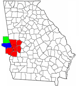 Location of the Columbus, Georgia–Auburn, Alabama CSA and its counties: Columbus, Georgia Metropolitan Statistical Area Auburn-Opelika, Alabama Metropolitan Statistical Area Valley, Alabama Micropolitan Statistical Area | |
| Country | United States |
| States | Georgia Alabama |
| Largest city | Columbus, Georgia |
| Population (2016 est.) | |
| • CSA | 501,961 (89th) |
| Area code(s) | 706, 762, 334 |
The Columbus–Auburn–Opelika, GA–AL Combined Statistical Area[1] is a trading and marketing area made up of six counties in Georgia and three in Alabama. The statistical area includes two metropolitan areas and one micropolitan area. As of the 2010 Census, the CSA had a population of 469,327 (though the US Census Bureau's 2013 estimate indicated a population of 501,649).[2][3]
The Combined Statistical Area consists of the:
- Columbus metropolitan area, population 308,755.
- Auburn–Opelika metropolitan area, population 158,991.
- Valley micropolitan area, population 34,215.
Until 2013, the area also officially consisted of the Tuskegee Micropolitan Statistical Area, which consisted of Macon County, Alabama. In 2013, the United States Office of Management and Budget removed Tuskegee Micropolitan Statistical Area from the list of metropolitan areas and from the Columbus–Auburn–Opelika CSA. At the same time, Valley Micropolitan Statistical Area was added to the Columbus–Auburn–Opelika CSA.[4]
Counties[]
In Georgia[]
- Chattahoochee County pop. 10,684
- Harris County pop. 34,475
- Marion County pop. 8,351
- Muscogee County pop. 194,160
- Stewart County pop. 6,199
- Talbot County pop. 6,865
In Alabama[]
- Lee County pop. 163,941
- Russell County pop. 57,781
- Chambers County pop. 33,615
Communities[]
The communities (both incorporated and unincorporated) in the combined statistical area are as follows. Bold name indicates the principal cities in the CSA:
- In Alabama
- Abanda pop. 192
- Auburn pop. 76,143[5]
- Beauregard pop. 5,234
- Bee Hive pop. unknown
- Beulah pop. 6,173
- Cusseta pop. 123
- Five Points pop. 146
- Fort Mitchell pop. 3,119
- Fredonia pop. 199
- Glenville pop. unknown
- Gold Hill pop. unknown
- Holy Trinity pop. unknown
- Huguley pop. 2,540
- Hurtsboro pop. 592
- Ladonia pop. 1,943
- LaFayette pop. 3,234
- Lanett pop. 7,897
- Loachapoka pop. 165
- Marvyn pop. 5,235
- Notasulga pop. 916
- Opelika pop. 26,477
- Penton pop. 201
- Phenix City pop. 30,067
- Roxana pop. 1,942
- Salem pop. 6,428
- Seale pop. 2,382
- Smiths Station pop. 21,756
- Standing Rock pop. 168
- The Bottle pop. unknown
- Valley pop. 9,198
- Waverly pop. 180
- In Georgia
- Buena Vista pop. 1,664
- Cataula pop. 3,784
- Columbus pop. 189,885
- Cusseta pop. 1,196
- Ellerslie pop. 3,292
- Fort Benning South pop. 11,737
- Hamilton pop. 307
- Hopewell pop. unknown
- Juniper pop. 2,830
- Mountain Hill pop. unknown
- Mulberry Grove pop. unknown
- Pine Mountain pop. 1,141
- Rehobeth pop. unknown
- Ridgeway pop. unknown
- Shiloh pop. 423
- Waverly Hall pop. 790
- West Point pop. 3,487
- Whitesville pop. 150
Education institutes[]
Higher education[]

Public[]
- Auburn University
- Columbus State University
- Columbus Technical College
- Chattahoochee Valley Community College (Phenix City)
- Georgia Military College - main campus in Milledgeville, Georgia
- Southern Union State Community College (Opelika)
- Troy University - campuses in Columbus, Fort Benning, and Phenix City, main campus in Troy, Alabama
Private, for profit[]
- (Columbus)
- Miller-Motte Technical College - main campus in Wilmington, North Carolina
- (Columbus)
- (Columbus)
- Strayer University - main campus in Baltimore, Maryland
Primary and secondary education[]
Transportation[]
Airports[]
Below is a list of the airports in the greater area, followed by their number of enplanements (commercial passenger boardings) that occurred at the airport in calendar year 2008.
Public[]
- Auburn-Opelika Robert G. Pitts Airport (IATA: AUO, ICAO: KAUO, FAA LID: AUO), 68
- Columbus Airport (IATA: CSG, ICAO: KCSG, FAA LID: CSG), 51,288
Private[]
- Harris County Airport (IATA: PIM, ICAO: KPIM, FAA LID: PIM), 116
- (FAA LID: AL56), n/a
- Lawson Army Airfield (IATA: LSF, ICAO: KLSF, FAA LID: LSF), 13,702
- Marion County Airport (FAA LID: 82A), n/a
Interstates[]
Principal Highways[]
State Highways[]
 Alabama State Route 13
 Alabama State Route 14
 Alabama State Route 26
 Alabama State Route 49
 Alabama State Route 51
 Alabama State Route 81
 Alabama State Route 147
 Alabama State Route 169
 Alabama State Route 267
 Georgia State Route 1
 Georgia State Route 18
 Georgia State Route 22
 Georgia State Route 26
 Georgia State Route 30
 Georgia State Route 41
 Georgia State Route 85
 Georgia State Route 103
 Georgia State Route 116
 Georgia State Route 137
 Georgia State Route 190
 Georgia State Route 219
 Georgia State Route 520
Sports[]
| Club | League |
|---|---|
| Auburn Tigers | NCAA Division I (Southeastern Conference) |
| Columbus River Dragons | Federal Prospects Hockey League |
| Columbus Riverballers | American Basketball Association |
| Columbus Lions | Southern Indoor Football League |
| Columbus State University Cougars | NCAA Division II (Peach Belt Conference) |
Shopping[]
Below are some notable shopping centers in the area:
- Columbus Park Crossing (Columbus)
- Peachtree Mall (Columbus)
- (Columbus)
- The Shoppes at Bradley Park (Columbus)
- (Opelika)
- Auburn Mall (Auburn)
Notable people[]
References[]
- ^ "Table 1. Annual Estimates of the Population of Metropolitan and Micropolitan Statistical Areas: April 1, 2000 to July 1, 2009 (CBSA-EST2009-01)". 2009 Population Estimates. United States Census Bureau, Population Division. 2010-03-23. Archived from the original (CSV) on 2010-06-15. Retrieved 2010-03-24.
- ^ "Results". United States Census Bureau. Retrieved 2014-05-22.
- ^ "Table 2. Annual Estimates of the Population of Combined Statistical Areas: April 1, 2000 to July 1, 2009 (CBSA-EST2009-02)". 2009 Population Estimates. United States Census Bureau, Population Division. 2010-03-23. Archived from the original (CSV) on 2010-04-20. Retrieved 2010-03-24.
- ^ OMB BULLETIN NO. 13-01: Revised Delineations of Metropolitan Statistical Areas, Micropolitan Statistical Areas, and Combined Statistical Areas, and Guidance on Uses of the Delineations of These Areas. Office of Management and Budget. February 28, 2013.
- ^ "QuickFacts Auburn city, Alabama". Population, Census, April 1, 2020. U.S. Census Bureau. August 14, 2020. Retrieved August 14, 2020.
| Central cities/Largest cities |  Location of the Columbus, Georgia-Auburn, Alabama CSA and its counties: Columbus, Georgia Metropolitan Statistical Area Auburn, Alabama Metropolitan Statistical Area Tuskegee, Alabama Micropolitan Statistical Area (defunct) | |
|---|---|---|
| Cities in Georgia |
| |
| Cities in Alabama | ||
| Counties in Georgia | ||
| Counties in Alabama | ||
- Auburn, Alabama
- Columbus metropolitan area, Georgia
- Auburn metropolitan area, Alabama
- Geography of Columbus, Georgia
- Combined statistical areas of the United States