Conca, Corse-du-Sud
show This article may be expanded with text translated from the corresponding article in French. (January 2009) Click [show] for important translation instructions. |
Conca | |
|---|---|
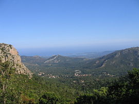 A view of the village of Conca from the GR20 | |
show Location of Conca | |
 Conca | |
| Coordinates: 41°44′09″N 9°20′02″E / 41.7358°N 9.3339°ECoordinates: 41°44′09″N 9°20′02″E / 41.7358°N 9.3339°E | |
| Country | France |
| Region | Corsica |
| Department | Corse-du-Sud |
| Arrondissement | Sartène |
| Canton | Bavella |
| Government | |
| • Mayor (2020–2026) | François Mosconi[1] |
| Area 1 | 77.96 km2 (30.10 sq mi) |
| Population (Jan. 2018)[2] | 1,134 |
| • Density | 15/km2 (38/sq mi) |
| Time zone | UTC+01:00 (CET) |
| • Summer (DST) | UTC+02:00 (CEST) |
| INSEE/Postal code | 2A092 /20135 |
| Elevation | 0–1,445 m (0–4,741 ft) (avg. 250 m or 820 ft) |
| 1 French Land Register data, which excludes lakes, ponds, glaciers > 1 km2 (0.386 sq mi or 247 acres) and river estuaries. | |


Conca is a commune in the Corse-du-Sud department of France on the island of Corsica. It is the southern terminus of the GR 20 walking route.
Population[]
|
|
See also[]
References[]
- ^ "Répertoire national des élus: les maires". data.gouv.fr, Plateforme ouverte des données publiques françaises (in French). 2 December 2020. Retrieved 7 December 2020.
- ^ "Populations légales 2018". INSEE. 28 December 2020.
| Wikimedia Commons has media related to Conca. |
| show Authority control |
|---|
This Corse-du-Sud geographical article is a stub. You can help Wikipedia by . |
Categories:
- Communes of Corse-du-Sud
- Corse-du-Sud geography stubs