Serra-di-Ferro
show This article may be expanded with text translated from the corresponding article in French. (January 2009) Click [show] for important translation instructions. |
Serra-di-Ferro
Sarra-di-Farru | |
|---|---|
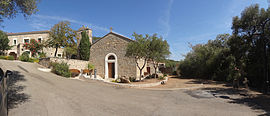 The chapel in Serra-di-Ferro | |
show Location of Serra-di-Ferro | |
 Serra-di-Ferro | |
| Coordinates: 41°43′50″N 8°47′58″E / 41.7306°N 8.7994°ECoordinates: 41°43′50″N 8°47′58″E / 41.7306°N 8.7994°E | |
| Country | France |
| Region | Corsica |
| Department | Corse-du-Sud |
| Arrondissement | Ajaccio |
| Canton | Taravo-Ornano |
| Government | |
| • Mayor (2020–2026) | Jean Alfonsi[1] |
| Area 1 | 32 km2 (12 sq mi) |
| Population (Jan. 2018)[2] | 485 |
| • Density | 15/km2 (39/sq mi) |
| Time zone | UTC+01:00 (CET) |
| • Summer (DST) | UTC+02:00 (CEST) |
| INSEE/Postal code | 2A276 /20140 |
| Elevation | 0–140 m (0–459 ft) |
| 1 French Land Register data, which excludes lakes, ponds, glaciers > 1 km2 (0.386 sq mi or 247 acres) and river estuaries. | |


Serra-di-Ferro is a commune in the Corse-du-Sud department of France on the island of Corsica.
Population[]
| Year | Pop. | ±% |
|---|---|---|
| 1962 | 277 | — |
| 1968 | 284 | +2.5% |
| 1975 | 334 | +17.6% |
| 1982 | 342 | +2.4% |
| 1990 | 327 | −4.4% |
| 1999 | 353 | +8.0% |
| 2006 | 420 | +19.0% |
| 2008 | 438 | +4.3% |
Sights[]
- Torra di Capriona
- Tour de Capannella
See also[]
References[]
- ^ "Répertoire national des élus: les maires". data.gouv.fr, Plateforme ouverte des données publiques françaises (in French). 2 December 2020.
- ^ "Populations légales 2018". INSEE. 28 December 2020.
External links[]
| Wikimedia Commons has media related to Serra-di-Ferro. |
| show Authority control |
|---|
This Corse-du-Sud geographical article is a stub. You can help Wikipedia by . |
Categories:
- Communes of Corse-du-Sud
- Corse-du-Sud geography stubs