Sotta
show This article may be expanded with text translated from the corresponding article in French. (January 2009) Click [show] for important translation instructions. |
Sotta
Sotta | |
|---|---|
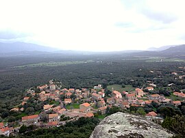 A panoramic view of Sotta from Punta | |
show Location of Sotta | |
 Sotta | |
| Coordinates: 41°32′44″N 9°11′44″E / 41.5456°N 9.1956°ECoordinates: 41°32′44″N 9°11′44″E / 41.5456°N 9.1956°E | |
| Country | France |
| Region | Corsica |
| Department | Corse-du-Sud |
| Arrondissement | Sartène |
| Canton | Grand Sud |
| Government | |
| • Mayor (2020–2026) | Jean-Marc Serra[1] |
| Area 1 | 67 km2 (26 sq mi) |
| Population (Jan. 2018)[2] | 1,373 |
| • Density | 20/km2 (53/sq mi) |
| Time zone | UTC+01:00 (CET) |
| • Summer (DST) | UTC+02:00 (CEST) |
| INSEE/Postal code | 2A288 /20146 |
| Elevation | 17–1,298 m (56–4,259 ft) (avg. 100 m or 330 ft) |
| 1 French Land Register data, which excludes lakes, ponds, glaciers > 1 km2 (0.386 sq mi or 247 acres) and river estuaries. | |


Sotta is a commune in the Corse-du-Sud department of France on the island of Corsica. It is one of communes in the canton of Grand Sud.
Geography[]
Sotta is 15 kilometres (9 mi) to the northeast of the commune of Figari on the road to Porto-Vecchio; it was created in 1853. The territory includes part of 1,299 metres (4,262 ft) Mount Cagna to the northwest; the remainder is in a plain scattered with hamlets, vines and groves of Cork Oak and Eucalyptus.[3]
Population[]
| Year | Pop. | ±% |
|---|---|---|
| 1962 | 535 | — |
| 1968 | 578 | +8.0% |
| 1975 | 683 | +18.2% |
| 1982 | 726 | +6.3% |
| 1990 | 762 | +5.0% |
| 1999 | 808 | +6.0% |
| 2008 | 886 | +9.7% |
Transportation[]
The village is near the airport at Figari.
It has been used as a special stage in the Tour de Corse.
See also[]
References[]
- ^ "Répertoire national des élus: les maires". data.gouv.fr, Plateforme ouverte des données publiques françaises (in French). 2 December 2020.
- ^ "Populations légales 2018". INSEE. 28 December 2020.
- ^ "France, le trésor des régions: Département: Corse-du-Sud" (in French). Retrieved 2008-05-06..
| Wikimedia Commons has media related to Sotta. |
This Corse-du-Sud geographical article is a stub. You can help Wikipedia by . |
Categories:
- Communes of Corse-du-Sud
- Corse-du-Sud geography stubs