Conejos, Colorado
Conejos, Colorado | |
|---|---|
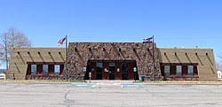 Conejos County Courthouse in Conejos. | |
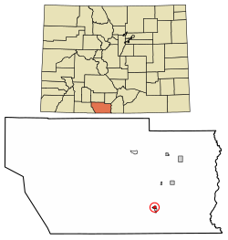 Location of the Conejos CDP in Conejos County, Colorado. | |
 Conejos Location of the Conejos CDP in the United States. | |
| Coordinates: 37°05′14″N 106°00′58″W / 37.0872571°N 106.0159931°WCoordinates: 37°05′14″N 106°00′58″W / 37.0872571°N 106.0159931°W[2] | |
| Country | |
| State | |
| County | Conejos County |
| Founded | 1858 |
| Government | |
| • Type | unincorporated town |
| Area | |
| • Total | 0.484 sq mi (1.254 km2) |
| • Land | 0.484 sq mi (1.254 km2) |
| • Water | 0.000 sq mi (0.000 km2) |
| Elevation | 7,897 ft (2,407 m) |
| Population (2010) | |
| • Total | 58 |
| • Density | 120/sq mi (46/km2) |
| Time zone | UTC-7 (MST) |
| • Summer (DST) | UTC-6 (MDT) |
| ZIP Code[3] | 81129 |
| Area code(s) | 719 |
| GNIS feature[1] | Conejos CDP |

Conejos is an unincorporated town, a post office, a census-designated place (CDP), and the county seat of Conejos County, Colorado, United States. The Conejos post office has the ZIP Code 81129.[3] At the United States Census 2010, the population of the Conejos CDP was 58, while the population of the 81129 ZIP Code Tabulation Area was 156 including adjacent areas.[4] Conejos is the only unincorporated county seat in the State of Colorado.
History[]

Conejos is a historic Hispanic settlement. Both the settlement and the county were initially named "Guadalupe".[5] A major historical and architectural feature of Conejos is the Our Lady of Guadalupe Catholic Church, founded in 1858.[5] The church was the first Catholic parish in modern-day Colorado and was constructed by Spanish colonists from New Mexico.[6]
The Conejos post office has been in operation since 1862.[7][8]
Geography[]
Conejos is located in southeastern Conejos County in the San Luis Valley. It is bordered to the south by the town of Antonito. U.S. Route 285 forms the eastern edge of the community and leads north 28 miles (45 km) to Alamosa, Colorado, and south 31 miles (50 km) to Tres Piedras, New Mexico.
The Conejos CDP has an area of 310 acres (1.254 km2), all land.[2]
Demographics[]
The United States Census Bureau initially defined the Conejos CDP for the United States Census 2010.
| Year | Pop. | ±% |
|---|---|---|
| 2010 | 58 | — |
| 2020 | — | |
| Source: United States Census Bureau | ||
See also[]
- Outline of Colorado
- State of Colorado
- Colorado cities and towns
- Colorado census designated places
- Colorado counties
- Colorado cities and towns
References[]
- ^ Jump up to: a b c "U.S. Board on Geographic Names: Domestic Names". United States Geological Survey. Retrieved December 21, 2020.
- ^ Jump up to: a b c "State of Colorado Census Designated Places - BAS20 - Data as of January 1, 2020". United States Census Bureau. Retrieved December 21, 2020.
- ^ Jump up to: a b "Look Up a ZIP Code". United States Postal Service. Retrieved December 21, 2020.
- ^ "2010: DEC Summary File 1". United States Census Bureau. Retrieved December 21, 2020.
- ^ Jump up to: a b "History". ologp.com. Conejos, Colorado: Our Lady of Guadalupe Parish. Retrieved 24 November 2020.
- ^ Howlett, William (1908). "Denver". The Catholic Encyclopedia. NewAdvent.org. Retrieved 5 January 2021.
- ^ "Post offices". Jim Forte Postal History. Archived from the original on 6 March 2016. Retrieved 25 June 2016.
- ^ Dawson, John Frank. Place names in Colorado: why 700 communities were so named, 150 of Spanish or Indian origin. Denver, CO: The J. Frank Dawson Publishing Co. p. 15.
External links[]
 Definitions from Wiktionary
 Media from Wikimedia Commons
 News from Wikinews
 Quotations from Wikiquote
 Texts from Wikisource
 Textbooks from Wikibooks
 Resources from Wikiversity
| show Municipalities and communities of Conejos County, Colorado, United States |
|---|

| show Authority control |
|---|
- County seats in Colorado
- Census-designated places in Conejos County, Colorado
- Census-designated places in Colorado
- Hispanic and Latino American history
- 1858 establishments in New Mexico Territory