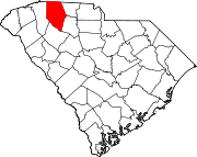
Converse, South Carolina
Converse | |
|---|---|
 Converse Location within the state of South Carolina | |
| Coordinates: 34°59′44″N 81°50′35″W / 34.99556°N 81.84306°WCoordinates: 34°59′44″N 81°50′35″W / 34.99556°N 81.84306°W | |
| Country | United States |
| State | South Carolina |
| County | Spartanburg |
| Area | |
| • Total | 0.701 sq mi (1.815 km2) |
| • Land | 0.690 sq mi (1.786 km2) |
| • Water | 0.011 sq mi (0.029 km2) |
| Population (2010) | |
| • Total | 608 |
| • Density | 870/sq mi (330/km2) |
| Time zone | UTC-5 (Eastern (EST)) |
| • Summer (DST) | UTC-4 (EDT) |
| ZIP codes | 29329 |
| FIPS code | 45083 |
Converse is a Census-designated place located in Spartanburg County in the U.S. State of South Carolina.[1] According to the 2010 United States Census, the population was 608.[2]
Geography[]
Converse is located at 34°59′44″N 81°50′35″W / 34.99556°N 81.84306°W (34.995665, -81.843059).[1] These coordinates place the CDP in the east side of the county, between the city of Spartanburg and the town of Cowpens.
According to the United States Census Bureau, the CDP has a total land area of 0.690 square mile (1.786 km2) and a total water area of 0.011 square miles (0.029 km2).[1]
Notable person[]
- Art Fowler, pitcher and pitching coach in Major League Baseball[3]
References[]
- ^ a b c "US Gazetteer files: 2010, 2000, and 1990". United States Census Bureau. 2011-02-12. Retrieved 2011-04-23.
- ^ See "U.S. Census website". United States Census Bureau. Retrieved 2008-01-31. for population numbers and for municipality and CDP lists in the 2010 Census.
- ^ "Art Fowler Stats". Baseball Almanac. Retrieved November 10, 2012.
Categories:
- Census-designated places in Spartanburg County, South Carolina
- Census-designated places in South Carolina
- South Carolina geography stubs

