Coolmunda, Queensland
| Coolmunda Queensland | |||||||||||||||
|---|---|---|---|---|---|---|---|---|---|---|---|---|---|---|---|
 Coolmunda | |||||||||||||||
| Coordinates | 28°26′17″S 151°13′56″E / 28.4380°S 151.2322°E | ||||||||||||||
| Population | 141 (2016 census)[1] | ||||||||||||||
| • Density | 0.5924/km2 (1.534/sq mi) | ||||||||||||||
| Postcode(s) | 4387 | ||||||||||||||
| Area | 238.0 km2 (91.9 sq mi) | ||||||||||||||
| Time zone | AEST (UTC+10:00) | ||||||||||||||
| LGA(s) | Goondiwindi Region | ||||||||||||||
| State electorate(s) | Southern Downs | ||||||||||||||
| Federal division(s) | Maranoa | ||||||||||||||
| |||||||||||||||

Coolmunda is a rural locality in the Goondiwindi Region, Queensland, Australia.[2] In the 2016 census, Coolmunda had a population of 141 people.[1]
Geography[]
The Cunningham Highway and South Western railway line pass through the locality from east (Oman Ama) to west (Inglewood).[3] The locality is served by the Cobba-Da-Mana railway station (28°24′28″S 151°13′25″E / 28.4077°S 151.2236°E).[4]
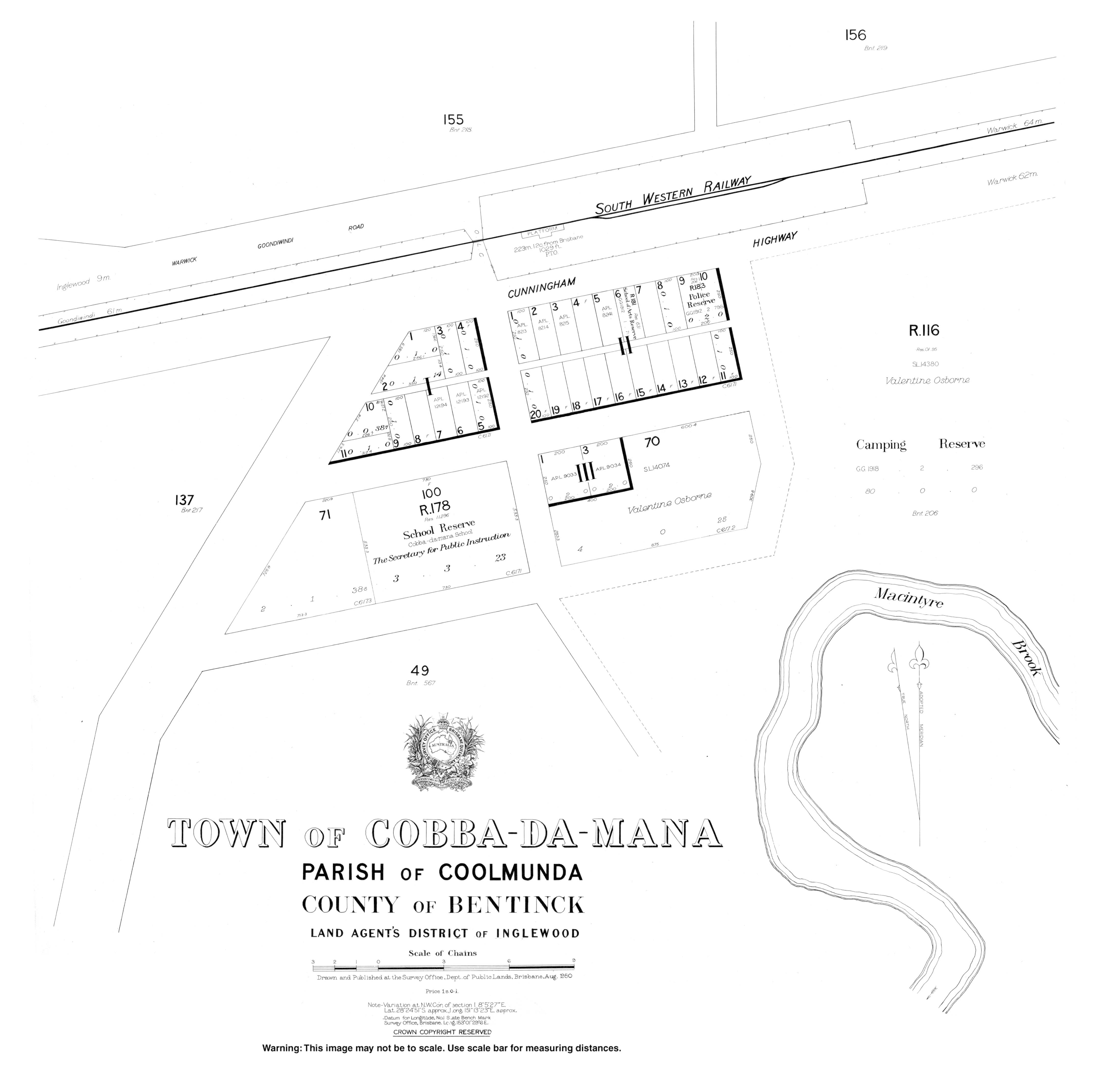
Coolmunda includes the neighbourhood of Cobba-Da-Mana around the Cobba-Da-Mana railway station.[5][6]
To the south of the highway and railway, Lake Coolmunda is a reservoir (28°27′00″S 151°14′00″E / 28.45°S 151.2333°E)[7] created by Coolmunda Dam (28°26′13″S 151°13′03″E / 28.4369°S 151.2175°E) impounding the Macintrye Brook.[8] It has a capacity of 69,000 megalitres (2,400×106 cu ft).[9]
The Coolmunda Conservation Park (28°27′34″S 151°12′29″E / 28.4594°S 151.2080°E) is to the south-west of the lake.[10] The park seeks to protect the endangered Leucopogon sp (Coolmunda D.Halford Q1635) and the vulnerable Eucalyptus virens (shiny-leaved ironbark).[11]
The land use is a mixture of dry and irrigated cropping and grazing on native vegetation.[3]
History[]
The name Coolmunda is thought to be an Aboriginal word, meaning a stream with a sandy bed.[2]
Coolmunda Provisional School opened 20 October 1883 but closed on 27 March 1885. It reopened in about March 1900 and became Coolmunda State School from 1 January 1909. In 1914 the school's name was changed to Waroo Road State School. The school closed in 1922, but reopened again in 1923 as a half-time school sharing a teacher with the Greenup Provisional School, but closed again in 1927. It recommenced in 1929 as a part-time school sharing a teacher with Greenup and Brush Creek Provisional School, closing in 1930.[12] It was located to the south of the Cunningham Highway where the highway and railway line diverge (28°24′57″S 151°09′48″E / 28.4157°S 151.1634°E).[13]
In May 1912 the Queensland Government auctioned 26 town allotments in the Town of Cobba-Da-Mana.[14]
The South Western railway opened from Thane to Inglewood on 8 July 1907, with the locality being served by the now-abandoned Coolmunda railway station (28°24′53″S 151°08′53″E / 28.4148°S 151.1481°E) and Cobba-Da-Mana railway station.[4][6][15]
Nanny Creek Provisional School opened on 1911 and closed on circa 1913.[12]
Cobba-Da-Mana State School opened on 22 January 1912 and closed in 1965.[12] It was just south-west of the Cobba-Da-Mana railway station, approximately 28°24′27″S 151°13′11″E / 28.4076°S 151.21960°E.[16]
On 15 August 1932 a new Coolmunda State School was established which operated until 1943.[12]
In the 2016 census, Coolmunda had a population of 141 people.[1]
Amenities[]
Bracker Creek Rural Fire Station is at 1782 Tobacco Road (28°28′43″S 151°12′46″E / 28.4786°S 151.2128°E).[17]
Attractions[]
The Coolamunda Dam offers fishing for a variety of stocked and local species; a Stocked Impoundment Permit is required.[9] There is a boat ramp at 28°25′26″S 151°13′02″E / 28.4240°S 151.2173°E.[18]
References[]
- ^ a b c Australian Bureau of Statistics (27 June 2017). "Coolmunda (SSC)". 2016 Census QuickStats. Retrieved 20 October 2018.

- ^ a b "Coolmunda – locality in Goondiwindi Region (entry 47806)". Queensland Place Names. Queensland Government. Retrieved 18 September 2020.
- ^ a b "Queensland Globe". State of Queensland. Retrieved 22 October 2020.
- ^ a b "Railway stations and sidings - Queensland". Queensland Open Data. Queensland Government. 2 October 2020. Archived from the original on 5 October 2020. Retrieved 5 October 2020.
- ^ "Cobba-Da-Mana – railway station in Goondiwindi Region (entry 7557)". Queensland Place Names. Queensland Government. Retrieved 26 December 2017.
- ^ a b "Railway stations and sidings - Queensland". Queensland Open Data. Queensland Government. 27 August 2020. Archived from the original on 5 October 2020. Retrieved 5 October 2020.
- ^ "Lake Coolmunda – reservoir in Goondiwindi Regional (entry 8122)". Queensland Place Names. Queensland Government. Retrieved 18 September 2020.
- ^ "Coolmunda Dam – dam wall in the Goondiwindi Region (entry 49994)". Queensland Place Names. Queensland Government. Retrieved 23 October 2020.
- ^ a b "Coolmunda Dam". Sunwater. Retrieved 22 October 2020.
- ^ "Coolmunda Conservation Park – conservation park in the Goondiwindi Region (entry 39411)". Queensland Place Names. Queensland Government. Retrieved 23 October 2020.
- ^ "Coolmunda Regional Park Management Statement" (PDF). Queensland Government. Archived (PDF) from the original on 23 October 2020. Retrieved 23 October 2020.
- ^ a b c d Queensland Family History Society (2010), Queensland schools past and present (Version 1.01 ed.), Queensland Family History Society, ISBN 978-1-921171-26-0
- ^ "Parish of Coolmunda" (Map). Queensland Government. 1930. Archived from the original on 31 August 2020. Retrieved 31 August 2020.
- ^ "Advertising". Warwick Examiner And Times. No. 4273. Queensland, Australia. 6 May 1912. p. 1. Retrieved 23 October 2020 – via National Library of Australia.
- ^ "Lost--A Name!". The Telegraph. No. 10, 808. Queensland, Australia. 9 July 1907. p. 2 (SECOND EDITION). Retrieved 23 October 2020 – via National Library of Australia.
- ^ "Town of Cobba-Da-Mana" (Map). Queensland Government. 1950. Retrieved 23 October 2020.
- ^ "Emergency services facilities - Queensland". Queensland Open Data. Queensland Government. 12 November 2020. Archived from the original on 15 November 2020. Retrieved 12 November 2020.
- ^ "Recreational Boating Facilities Queensland". Queensland Open Data. Queensland Government. 27 March 2020. Archived from the original on 22 October 2020. Retrieved 22 October 2020.
- Goondiwindi Region
- Localities in Queensland