Glenarbon, Queensland
| Glenarbon Queensland | |||||||||||||||
|---|---|---|---|---|---|---|---|---|---|---|---|---|---|---|---|
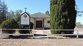
 St Paul's Lutheran Church, 2019 | |||||||||||||||
 Glenarbon | |||||||||||||||
| Coordinates | 28°35′52″S 150°54′20″E / 28.5977°S 150.9055°E | ||||||||||||||
| Population | 36 (2016 census)[1] | ||||||||||||||
| • Density | 0.1236/km2 (0.320/sq mi) | ||||||||||||||
| Postcode(s) | 4385 | ||||||||||||||
| Area | 291.3 km2 (112.5 sq mi) | ||||||||||||||
| Time zone | AEST (UTC+10:00) | ||||||||||||||
| LGA(s) | Goondiwindi Region | ||||||||||||||
| State electorate(s) | Southern Downs | ||||||||||||||
| Federal division(s) | Maranoa | ||||||||||||||
| |||||||||||||||
Glenarbon is a rural locality in the Goondiwindi Region, Queensland, Australia.[2] It is on the border of Queensland and New South Wales.[3] In the 2016 census, Glenarbon had a population of 36 people.[1]
Geography[]
The north-east and south-east of the locality is within the Yelarbon State Forest which extends into Beebo to the south-east and west and into Brush Creek to the east.[3]
History[]
Glenarbon Provision School opened on 17 March 1933, becoming Glenarbon State School in 1940. It closed in 1982.[4] The school was located just to the south of the Texas Yelarbon Road at 28°41′01″S 150°53′28″E / 28.6835°S 150.8910°E within the present-day boundaries of Beebo.[5]
St Paul's Lutheran Church was established circa December 1959.[6][7]
In the 2016 census, Glenarbon had a population of 36 people.[1]
Amenities[]
The former school site is now a recreational reserve operated by the Goondiwindi Regional Council.[3]
St Paul's Lutheran Church is on Glenarbon Church Road at 28°40′42″S 150°53′31″E / 28.6783°S 150.8919°E, which is also now within Beebo. The church has a small cemetery.[3]
References[]
- ^ a b c Australian Bureau of Statistics (27 June 2017). "Glenarbon (SSC)". 2016 Census QuickStats. Retrieved 20 October 2018.

- ^ "Glenarbon – locality in Goondiwindi Region (entry 47808)". Queensland Place Names. Queensland Government. Retrieved 6 May 2020.
- ^ a b c d "Queensland Globe". State of Queensland. Retrieved 6 May 2020.
- ^ Queensland Family History Society (2010), Queensland schools past and present (Version 1.01 ed.), Queensland Family History Society, ISBN 978-1-921171-26-0
- ^ "Parish of Beebo" (Map). Queensland Government. 1929. Archived from the original on 30 August 2020. Retrieved 30 August 2020.
- ^ "LUTHERAN CONVENTION OPENS AT KALBAR". Queensland Times. No. 19, 752. Queensland, Australia. 24 April 1950. p. 2 (DAILY). Archived from the original on 30 August 2020. Retrieved 30 August 2020 – via National Library of Australia.
- ^ "Glenarbon's 60th Anniversary of Church Building Service". Qld District. Lutheran Church of Australia. 25 November 2019. Archived from the original on 30 August 2020. Retrieved 30 August 2020.
Further reading[]
- Boddington, Ester; Donges, J.; Texas Historical Society (1995), The settlements of Glenarbon and Eldorado as I remember them c. 1932 & Short history of the border area of Queensland covered by the Glenarbon Beebo Branch of the Queensland Country Women's Association, Texas Historical Society
External links[]
![]() Media related to Glenarbon, Queensland at Wikimedia Commons
Media related to Glenarbon, Queensland at Wikimedia Commons
- Goondiwindi Region
- Localities in Queensland
