Coronado National Forest
| Coronado National Forest | |
|---|---|
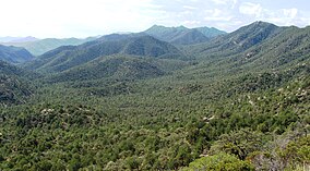 Coronado National Forest and Chiricahua Mountains in southern Arizona | |
 Location in Arizona | |
| Location | Arizona and New Mexico, US |
| Nearest city | Tucson, Arizona, US |
| Coordinates | 31°59′47″N 110°18′32″W / 31.99639°N 110.30889°WCoordinates: 31°59′47″N 110°18′32″W / 31.99639°N 110.30889°W |
| Area | 1,780,000 acres (7,200 km2) |
| Established | April 11, 1902 |
| Governing body | US Forest Service |
| Website | Coronado National Forest |


The Coronado National Forest is a United States National Forest that includes an area of about 1.78 million acres (7,200 km2) spread throughout mountain ranges in southeastern Arizona and southwestern New Mexico.
It is located in parts of Cochise, Graham, Santa Cruz, Pima, and Pinal Counties in Arizona, and Hidalgo County in New Mexico.
The national forest is divided into five ranger districts, which are not contiguous; each consists of multiple sky island mountain ranges.
The Santa Catalina Ranger District near the city of Tucson comprises the Santa Catalina and Rincon Mountains. Included in this area are the highest peak of the Santa Catalinas, Mount Lemmon, the rugged Pusch Ridge Wilderness Area, and the popular Sabino Canyon. Much of this district was part of Santa Catalina National Forest before its inclusion in Coronado.
The Safford Ranger District comprises the mountain ranges surrounding the city of Safford, Arizona. These five ranges are the Pinaleño, Galiuro, Santa Teresa, , and . Included in this area is the highest peak of the Pinaleños, Mount Graham. Mount Graham National Forest was a formerly separate national forest, combined into Crook National Forest on July 1, 1908. In 1953, part of Crook was absorbed into Coronado.
The Nogales Ranger District comprises four mountain ranges north and west of Nogales, Arizona. These ranges are the Santa Rita, Tumacacori, Pajarito, and San Luis Mountains. Included in this area are Mount Hopkins, Mount Wrightson, and Madera Canyon, all located in the Santa Ritas. In the early 20th century, this area included two national forests which were absorbed into Coronado: Santa Rita National Forest and Tumacacori National Forest.[1]
The Douglas Ranger District comprises three mountain ranges north and east of Douglas, Arizona. These ranges are the Chiricahua, Dragoon, and Peloncillo Mountains. A portion of the ranger district in the Peloncillos extends into New Mexico. The district comprises three formerly separate national forests: Chiricahua National Forest, Dragoon National Forest, and Peloncillo National Forest, all combined into Coronado.[1]
The Sierra Vista Ranger District comprises three mountain ranges west of Sierra Vista, Arizona. These ranges are the Huachuca, Patagonia, and Whetstone Mountains. Included in this area is the highest peak in the Huachucas, Miller Peak, and the region of the Huachucas known as Canelo Hills. The district includes the formerly separate Huachuca National Forest[1]
Wilderness[]

The Coronado National Forest contains eight designated wilderness areas, with at least one in each ranger district. Congress defines "wilderness" as an area "untrammeled by man." Common activities in the Coronado National Forest wilderness areas include hiking, horseback riding, camping, hunting, and fishing. The use of mechanized or motorized equipment, including bicycles, generators, and chain saws, is prohibited.[2]
- (Douglas District)
- Galiuro Wilderness (Safford District)
- (Sierra Vista District)
- (Nogales District)
- Pajarita Wilderness (Nogales District)
- Pusch Ridge Wilderness (Santa Catalina District)
- (Santa Catalina District)
- (Safford District)
Campgrounds[]
The public campgrounds located within the Coronado National Forest,[3] most requiring a daily/nightly fee (see Coronado National Forest official website for accurate and current details), are:
| Campground | Status * | Elevation | Fee | Mountain range |
|---|---|---|---|---|
| Arcadia | Open | 6700 | Yes | Pinaleño Mountains |
| Bathtub | Open | 6300 | Yes | Chiricahua Mountains |
| Bog Springs | Open | 5200 | Yes | Santa Rita Mountains |
| Cochise Stronghold | Developed sites closed until Sept 1 Dispersed camping is open |
5000 | Yes | Dragoon Mountains |
| Cunningham | Open | 9000 | Yes | Pinaleño Mountains |
| Cypress Park | Open | 6000 | Yes | Chiricahua Mountains |
| General Hitchcock | Open | 6000 | Yes | Santa Catalina Mountains |
| Gordon Hirabayashi | Open | 5000 | Yes | Santa Catalina Mountains |
| Herb Martyr | Open | 5800 | Yes | Chiricahua Mountains |
| Hospital Flat | Open | 9000 | Yes | Pinaleño Mountains |
| Idlewilde | Open | 5000 | Yes | Chiricahua Mountains |
| John Hands | Open | 5600 | No | Chiricahua Mountains |
| Lakeview (Parker Cyn Lake) |
Open | 5400 | Yes | Huachuca Mountains (Canelo Hills) |
| Molino Basin | Open | 4500 | Yes | Santa Catalina Mountains |
| Peppersauce | Open | 4700 | Yes | Santa Catalina Mountains |
| Pinery Canyon | Open | 7000 | No | Chiricahua Mountains |
| Ramsey Vista | Open | 7400 | Yes | Huachuca Mountains |
| Reef Townsite | Open | 7200 | Yes | Huachuca Mountains |
| Riggs Flat | Open | 8600 | Yes | Pinaleño Mountains |
| Rose Canyon | Open | 7000 | Yes | Santa Catalina Mountains |
| Rucker Forest Camp | Open | 6500 | Yes | Chiricahua Mountains |
| Rucker Lake | Open | 6300 | Yes | Chiricahua Mountains |
| Rustler Park | Open | 8500 | Yes | Chiricahua Mountains |
| Shannon | Open | 9100 | Yes | Pinaleño Mountains |
| Soldier Creek | Closed | 9300 | Yes | Pinaleño Mountains |
| Spencer Canyon | Open | 8000 | Yes | Santa Catalina Mountains |
| Stewart | Open | 5100 | Yes | Chiricahua Mountains |
| Stockton Pass | Open | 5600 | No | Pinaleño Mountains |
| Sunny Flat | Open | 5200 | Yes | Chiricahua Mountains |
| Sycamore | Open | 6200 | Yes | Chiricahua Mountains |
| W Turkey Creek | Open | 5900 | Yes | Chiricahua Mountains |
| White Rock | Open | 4000 | Yes | Tumacacori Mountains |
* Information is accurate as of Tuesday, 17 June 2008 at 13:39:50 EDT
See also[]
References[]
- ^ Jump up to: a b c Davis, Richard C. (September 29, 2005), National Forests of the United States (pdf), Forest History Society
- ^ Coronado National Forest Wilderness
- ^ Coronado National Forest - Campground Guide
External links[]
- Coronado National Forest Web Site
- Forest History Society
- Hikes in the Coronado National Forest at HikeArizona.COM
- Listing of the National Forests of the United States and Their Dates (from Forest History Society website) Text from Davis, Richard C., ed. Encyclopedia of American Forest and Conservation History. New York: Macmillan Publishing Company for the Forest History Society, 1983. Vol. II, pp. 743-788.
| show Authority control |
|---|
- Coronado National Forest
- National Forests of Arizona
- Protected areas of Pinal County, Arizona
- Protected areas of Cochise County, Arizona
- Protected areas of Graham County, Arizona
- Protected areas of Santa Cruz County, Arizona
- Protected areas of Pima County, Arizona
- Protected areas of Hidalgo County, New Mexico
- National Forests of New Mexico
- Protected areas established in 1902
- 1902 establishments in Arizona Territory