Nez Perce National Forest
| Nez Perce National Forest | |
|---|---|
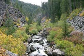 Crooked Creek in Gospel Hump Wilderness | |
 | |
| Location | Idaho County, Idaho, United States |
| Nearest city | Grangeville, Idaho |
| Coordinates | 45°27′N 115°55′W / 45.450°N 115.917°WCoordinates: 45°27′N 115°55′W / 45.450°N 115.917°W |
| Area | 2,224,091 acres (9,000.58 km2) |
| Established | July 1, 1908 |
| Governing body | U.S. Forest Service |
| Website | Nez Perce-Clearwater National Forests |

The Nez Perce National Forest is a 2,224,091-acre (9,000.58 km2) United States National Forest located in west-central Idaho.[1] The forest is bounded on the east by the state of Montana, on the north by the Clearwater National Forest, on the west by a portion of the Wallowa–Whitman National Forest and on the south by the Payette National Forest.
The mountains in this forest provide wildlife habitat for timber wolf, raccoon, moose, black bear, coyote, cougar, elk, two species of fox, bald eagle, pika, beaver, flammulated owl, pine marten, white-tailed and mule deer, muskrat, river otter, peregrine falcon, mink, marmot, fisher, and mountain goat.
In 2012, Nez Perce National Forest and Clearwater National Forest were administratively combined as Nez Perce-Clearwater National Forests, with headquarters in Kamiah, Idaho.[2] There are local ranger district offices in Elk City, Grangeville, Kooskia, and White Bird.[3]
Nez Perce was established on July 1, 1908 by the U.S. Forest Service with 1,946,340 acres (7,876.6 km2) from parts of Bitterroot National Forest and Weiser National Forest. On October 29, 1934, part of Selway National Forest was added.[4]
Wilderness areas[]
There are four officially designated wilderness areas within Nez Perce National Forest that are part of the National Wilderness Preservation System. Three of these are partly or mostly in neighboring National Forests (as indicated).
- Frank Church—River of No Return Wilderness (only 4.68% lies within Nez Perce NF; mostly in either Payette National Forest, Challis NF, Salmon NF, Boise NF, or Bitterroot NF)[5]
- Gospel Hump Wilderness
- Hells Canyon Wilderness (mostly in Wallowa National Forest; partly in Payette National Forest, Whitman National Forest, or BLM land)
- Selway-Bitterroot Wilderness (partly in Bitterroot NF; Clearwater National Forest; Lolo NF)

See also[]
- Nez Perce tribe
References[]
- ^ Table 6 - NFS Acreage by State, Congressional District and County - United States Forest Service - September 30, 2007
- ^ "About the Forest". Nez Perce-Clearwater National Forests. Retrieved 6 June 2016.
- ^ USFS Ranger Districts by State
- ^ Davis, Richard C. (September 29, 2005), National Forests of the United States (PDF), The Forest History Society, archived from the original (PDF) on October 28, 2012, retrieved July 20, 2009
- ^ Frank Church-River of No Return Wilderness acreage breakdown, Wilderness.net
External links[]
| Wikimedia Commons has media related to Nez Perce National Forest. |
| show Authority control |
|---|
This article related to a protected area in Idaho is a stub. You can help Wikipedia by . |
This Idaho County, Idaho state location article is a stub. You can help Wikipedia by . |
- Nez Perce National Forest
- National Forests of Idaho
- Protected areas of Idaho County, Idaho
- Protected areas established in 1908
- 1908 establishments in Idaho
- Idaho geography stubs
- Western United States protected area stubs