Trail of the Coeur d'Alenes
| Trail of the Coeur d'Alenes | |
|---|---|
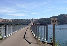
 Crossing Lake Coeur d'Alene on the Chatcolet Bridge, a long wooden trestle bridge with a 1921-built, former-swing-span truss bridge section | |
| Length | 73 miles (117 km) |
| Location | Northern Idaho, U.S. |
| Established | March 2004 |
| Designation | Idaho state park |
| Trailheads | Mullan, Idaho; Plummer, Idaho 47°30′35″N 116°32′13″W / 47.50972°N 116.53694°WCoordinates: 47°30′35″N 116°32′13″W / 47.50972°N 116.53694°W |
| Use | Biking, inline skating, hiking |
| Elevation | |
| Highest point | 3,280 ft (1,000 m) (Mullan) |
| Lowest point | 2,200 ft (670 m) (Harrison) |
| Hiking details | |
| Trail difficulty | Easy |
| Season | Year-round |
| Sights | Silver Valley, Lake Coeur d'Alene, Heyburn State Park, Palouse |
| Surface | Asphalt |
| Maintained by | Idaho Department of Parks and Recreation |
| Website | Trail of the Coeur d'Alenes
 Mullan Plummer |

The Trail of the Coeur d'Alenes is a rail trail in the northwest United States, in northern Idaho. It follows the former Union Pacific Railroad right-of-way from Mullan, a mountain mining town near the Montana border, westward to Plummer, a town on the prairie near the Washington border.[1][2] Generally following the Coeur d'Alene River, the rail line was abandoned in 1991[3] and the trail officially opened in March 2004.[4]
Trail route[]
The trail's 73-mile (117 km) route winds through the mountainous terrain of historic Silver Valley, into the chain lakes region, along the shore of Lake Coeur d'Alene, over the Chatcolet Bridge to Heyburn State Park, and concludes with a climb to the northern Palouse prairie. Trail users can continue along a bike path in Washington that leads to Spokane. The eastern half of the trail in Shoshone County has Interstate 90 nearby. In Kootenai County, I-90 leaves the river to head over Fourth of July Summit to the lake's north shore and the city of Coeur d'Alene, while the river and trail descends southwest toward Harrison, closer to State Highway 3.
Environmental impact[]
The trail is not only a recreational facility, but also a solution to environmental problems left behind by Idaho's mining industry. Silver, lead, and zinc were discovered in the valley around 1884, and a rail line was built to access the mines around 1888.[1] Much of the rock in the railbed was either waste rock from mines, or tailings containing heavy metals. The railbed was also contaminated with spillage from passing trains.[5]
To remedy these environmental problems, the Union Pacific Railroad, U.S. government, the State of Idaho, and the Coeur d'Alene Tribe partnered to build a trail.[6] The thick asphalt and the gravel barriers on the sides of the trail serve as a permanent cap to isolate contaminants from the surrounding environment. A portion of the trail is within the Coeur d'Alene Reservation, and an approximately 15-mile (24 km) section of the trail is managed by the Tribe.[4][A]
Recreational features[]
The Trail of the Coeur d'Alenes includes camping facilities and rest areas regularly. The trail leads through protected marsh lands, offering the cyclist a glimpse of eagle and osprey nests, moose, elk, and a variety of ducks and other wildlife, as well as some rare species of wildflowers and accompanying butterflies as a result of the age-old soot from the old railroad.[citation needed]
See also[]
- Route of the Hiawatha Trail
- List of Idaho state parks
- National Parks in Idaho
Notes[]
References[]
- ^ Jump up to: a b Cernera, Phillip; Gunderman, Jack; Ridolfi, Callie (July 25, 2002). "A trail of mining waste turns into a trail of recreation". Seattle Daily Journal of Commerce. Seattle, Wash. Retrieved July 6, 2017.
- ^ Quinn, Molly (June 1, 2004). "Trail of the Coeur d'Alenes". Spokesman-Review. Spokane, Wash. (map). p. A11. Retrieved July 6, 2017.
- ^ Barker, Eric (July 31, 2004). "From rail to grail: Long-awaited Trail of the Coeur d'Alenes". Lewiston Morning Tribune. Lewiston, Id. Retrieved April 11, 2017.
- ^ Jump up to: a b "Lake Management: Recreation Management Programs". Official Site of the Coeur d' Alene Tribe. Coeur d'Alene Tribe. Retrieved April 11, 2017.
- ^ Hagengruber, James (June 1, 2004). "The resurrection of Harrison". Spokesman-Review. Spokane, Wash. p. A1. Retrieved July 6, 2017.
- ^ Titone, Julie (February 17, 1999). "Many questions arise over trail proposal". Spokesman-Review. Spokane, Wash. p. B1. Retrieved July 6, 2017.
- ^ Villa, Clifford J. (2001). "Cleaning Up the Tracks: Superfund Meets Rails-To-Trails". University of New Mexico. Retrieved June 16, 2018.
External links[]
| Wikimedia Commons has media related to Trail of the Coeur d'Alenes. |
- Trail of the Coeur d'Alenes Brochure and Map Idaho Department of Parks & Recreation and the Coeur d’Alene Tribe
- Trail of the Coeur d'Alenes Idaho Parks and Recreation
- Trail of the Coeur d'Alenes Trail Link
- Friends of the Coeur d'Alene Trail
- Protected areas of Benewah County, Idaho
- State parks of Idaho
- Protected areas of Kootenai County, Idaho
- Rail trails in Idaho
- Protected areas of Shoshone County, Idaho
- 2004 establishments in Idaho
- Long-distance trails in the United States
- Protected areas established in 2004