List of Idaho state parks
Hold cursor over locations to display park name; click to go to park article.
This is a list of Idaho’s 27 state parks managed by the Idaho Department of Parks and Recreation. In Idaho state code, there are 30 state parks listed, including Mowry State Park, Veteran's State Park, and Glade Creek. While these three remain state property, they are managed by entities other than the state of Idaho:
- Veterans Park in Boise is managed by the City of Boise Parks Department
- Mowry State Park on Lake Coeur d'Alene is managed by Kootenai Parks and Waterways
- Glade Creek near Lolo Pass is managed by the U.S. Forest Service
State parks and trails[]
| Name | County | Size[1] (acreage or length) |
Elevation[1] (range, when available) |
Estab- lished[2] |
Image | Remarks[1] | ||
|---|---|---|---|---|---|---|---|---|
| Ashton to Tetonia Trail | Fremont, Teton | 29.6 mi | 47.6 km | 5,277–6,064 ft | 1,608–1,848 m | 2010 | Follows the abandoned railroad grade of the Teton Valley Branch of the Union Pacific Railroad. | |
| Bear Lake State Park | Bear Lake | 966 acres | 391 ha | 5,900 ft | 1,800 m | 1969 | Comprises two properties on the shore of Bear Lake. | |
| Bruneau Dunes State Park | Owyhee | 4,800 acres | 1,900 ha | 2,470 ft | 750 m | 1967 |  |
Showcases dunes rising up to 470 feet (140 m) above several small lakes. |
| Castle Rocks State Park | Cassia | 1,692 acres | 685 ha | 5,620 ft | 1,710 m | 2003 | 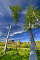 |
Features granite spires and an early-20th century ranch at the base of Cache Peak. |
| City of Rocks National Reserve | Cassia | 14,407 acres | 5,830 ha | 5,720 ft | 1,740 m | 1988 | Showcases granite spires and monoliths popular for rock climbing. | |
| Coeur d'Alene Parkway State Park | Kootenai | 5.7 mi | 9.2 km | 2,187 ft | 667 m | Provides a walking and bicycling path along the north shore of Lake Coeur d'Alene, as the east end of the North Idaho Centennial Trail. | ||
| Dworshak State Park | Clearwater | 850 acres | 340 ha | 1,600 ft | 490 m | 1989 |  |
Comprises three properties on the shore of the reservoir created by the Dworshak Dam. |
| Eagle Island State Park | Ada | 545 acres | 221 ha | 2,724 ft | 830 m | 1983 |  |
Features day-use recreational facilities, including a swimming beach and water slide, near Boise. |
| Farragut State Park | Kootenai | 4,000 acres | 1,600 ha | 2,054 ft | 626 m | 1966 |  |
Features recreational facilities on Lake Pend Oreille at the site of a former U.S. Navy training base. |
| Harriman State Park | Fremont | 11,000 acres | 4,500 ha | 6,120 ft | 1,870 m | 1977 | Preserves expansive wildlife habitat, a historic ranch, and fly fishing in Henrys Fork within the Greater Yellowstone Ecosystem. | |
| Hells Gate State Park | Idaho | 960 acres | 390 ha | 733 ft | 223 m | 1973 |  |
Contains the mouth of Hells Canyon, the deepest canyon in North America. |
| Henrys Lake State Park | Fremont | 585 acres | 237 ha | 6,470 ft | 1,970 m | 1973 |  |
Adjoins Henrys Lake 15 miles (24 km) west of Yellowstone National Park. |
| Heyburn State Park | Benewah | 8,106 acres | 3,280 ha | 2,128 ft | 649 m | 1908 |  |
Preserves three lakes in the oldest state park in the Pacific Northwest. |
| Lake Cascade State Park | Valley | 500 acres | 200 ha | 4,828 ft | 1,472 m | 1999 |  |
Comprises properties dispersed around Lake Cascade's 86 miles (138 km) of shoreline. |
| Lake Walcott State Park | Minidoka | 65 acres | 26 ha | 4,700 ft | 1,400 m | 1999 |  |
Provides water recreation at the northwest end of Lake Walcott. |
| Land of the Yankee Fork State Park | Custer | 521 acres | 211 ha | 5,001–6,500 ft | 1,524–1,981 m | 1990 |  |
Interprets Idaho's frontier mining history, including the ghost towns of Bayhorse, Bonanza, and Custer. |
| Lucky Peak State Park | Ada | 240 acres | 97 ha[3] | 2,750 ft | 840 m | 1956 |  |
Comprises three day-use areas east of Boise on Lucky Peak Lake and the Boise River. |
| Massacre Rocks State Park | Power | 990 acres | 400 ha | 4,400 ft | 1,300 m | 1967 |  |
Preserves a boulder field on the Snake River where emigrants on the Oregon and California Trails feared ambush by Native Americans. |
| McCroskey State Park | Benewah, Latah |
5,300 acres | 2,100 ha | 3,039–4,324 ft | 926–1,318 m | 1955 |  |
Offers a scenic drive along a ridge overlooking the Palouse. |
| Old Mission State Park | Kootenai | 18 acres | 7.3 ha | 2,200 ft | 670 m | 1975 |  |
Interprets the oldest standing building in Idaho, finished in 1853 as a Jesuit mission to the Coeur d'Alene people. |
| Ponderosa State Park | Valley | 1,515 acres | 613 ha | 5,050 ft | 1,540 m | 1973 | Preserves a peninsula jutting into Payette Lake. | |
| Priest Lake State Park | Bonner | 755 acres | 306 ha | 2,440 ft | 740 m | 1973 | Comprises three units around Priest Lake in the Selkirk Mountains. | |
| Round Lake State Park | Bonner | 142 acres | 57 ha | 2,122 ft | 647 m | 1965 |  |
Surrounds a 58-acre (23 ha) lake. |
| Thousand Springs State Park | Gooding | 1,500 acres | 610 ha | 2,800 ft | 850 m | 2005 |  |
Comprises multiple units in the Hagerman Valley where numerous springs charged by the Snake River Aquifer flow out of the eastern valley wall. |
| Three Island Crossing State Park | Elmore | 613 acres | 248 ha | 2,484 ft | 757 m | 1968 | Interprets the site of a ford over the Snake River on the Oregon Trail, | |
| Trail of the Coeur d'Alenes | Benewah, Kootenai, Shoshone |
73 mi | 117 km | 2,200–3,280 ft | 670–1,000 m | 2004 |  |
Comprises a 73-mile (117 km) paved rail trail across the Idaho Panhandle. |
| Winchester Lake State Park | Lewis | 418 acres | 169 ha | 3,900 ft | 1,200 m | 1969 | Surrounds a 104-acre (42 ha) lake known for its rainbow trout fishing. | |
See also[]
 Idaho portal
 Pacific Northwest portal
- List of U.S. national parks
- National Parks in Idaho
References[]
- ^ a b c All data come from the respective Idaho state park's webpage unless otherwise noted.
- ^ "History: State Lands in Idaho". Idaho Museum of Natural History. Retrieved October 16, 2017.
- ^ "Idaho State Parks Fast Facts" (PDF). Lesson 6: State Park By Design. Idaho Parks and Recreation. Retrieved October 21, 2018.
External links[]
Categories:
- State parks of Idaho
- Idaho-related lists
- Lists of state parks of the United States