List of Indiana state parks

The U.S. state of Indiana has 24 state parks maintained and operated by Indiana Department of Natural Resources (DNR).[1] In addition, a separate state agency operates White River State Park in downtown Indianapolis.[2] Marion and Clark are the only counties to have two parks. Brown County, the largest state park, has the greatest number of visitors, followed by Indiana Dunes State Park.[1]
Richard Lieber was instrumental in the foundation of the Indiana State Park system. The first state park in Indiana was McCormick's Creek State Park, in Owen County in 1916, followed in the same year by Turkey Run State Park in Parke County. The number of state parks rose steadily in the 1920s, mostly by donations of land from local authorities to the state government. Of the initial twelve parks, only Muscatatuck State Park is no longer a state park, having been given back to Jennings County in 1968.[3] It was during the Great Depression of the 1930s that much infrastructure was built within the parks, constructed by New Deal agencies such as the Civilian Conservation Corps and the Works Progress Administration, with the majority of this Depression-era construction still in use in the 21st century. This delay in infrastructure was due in part to Richard Lieber's belief that the parks should be kept as natural as possible.[4]
Initially, the state parks were intended to feature natural environments in Indiana. The establishment of Mounds State Park for its historical nature and Shakamak State Park (an abandoned strip mine) purely for recreational purposes represented changes from the initial purposes of the Indiana state park system.[5]
While Indiana does not have as many state parks as some other states, it has avoided obtaining too many smaller properties that would be hard to manage. A goal of having at least one state park within an hour's drive for every Hoosier was met when Prophetstown State Park was established in 2004.[6]
State parks[]
| Park Name | Image | City | County or Counties | Year Established | Size[7] | Remarks[7] |
|---|---|---|---|---|---|---|
| Brown County | 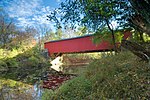
|
Nashville 39°07′N 86°16′W / 39.11°N 86.26°W |
Brown | 1929 | 15,776 acres (63.84 km2) | Largest State Park in Indiana[8] |
| Chain O' Lakes | 
|
Albion 41°20′N 85°23′W / 41.33°N 85.38°W |
Noble | 1960 | 2,718 acres (11.00 km2) | Features eight connected kettle lakes[9] |
| Charlestown | 
|
Charlestown 38°26′N 85°38′W / 38.43°N 85.63°W |
Clark | 1996 | 5,100 acres (21 km2) | Built on the grounds of the old Indiana Army Ammunition Plant[10] |
| Clifty Falls | 
|
Madison 38°46′N 85°25′W / 38.76°N 85.42°W |
Jefferson | 1920 | 1,416 acres (5.73 km2) | Features a canyon that has daylight only at midday[11] |
| Falls of the Ohio | 
|
Clarksville 38°16′37″N 85°45′47″W / 38.277°N 85.763°W |
Clark | 1990 | 165 acres (0.67 km2) | Offers views of the Falls of the Ohio and Louisville, Kentucky[12] |
| Fort Harrison | 
|
Indianapolis 39°52′N 86°01′W / 39.87°N 86.01°W |
Marion | 1996 | 1,700 acres (6.9 km2) | Built on the site of old Fort Benjamin Harrison[13] |
| Harmonie | —
|
New Harmony 38°04′N 87°57′W / 38.06°N 87.95°W |
Posey | 1966 | 3,465 acres (14.02 km2) | Near historic Rappite and Owenite villages.[14] |
| Indiana Dunes | 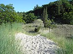
|
Porter 41°40′N 87°02′W / 41.66°N 87.04°W |
Porter | 1925 | 2,182 acres (8.83 km2) | Attached to Indiana Dunes National Park.[15] |
| Lincoln | 
|
Lincoln City 38°06′N 87°00′W / 38.10°N 87.00°W |
Spencer | 1932 | 1,847 acres (7.47 km2) | Across from Lincoln Boyhood National Memorial, it was the last state park established by Richard Lieber.[16] |
| McCormick's Creek | 
|
Spencer 39°17′N 86°44′W / 39.29°N 86.73°W |
Owen | 1916 | 1,924 acres (7.79 km2) | First state park in Indiana[17] |
| Mounds | 
|
Anderson 40°06′N 85°37′W / 40.10°N 85.62°W |
Madison | 1930 | 290 acres (1.2 km2) | [18] |
| O'Bannon Woods | 
|
Corydon 38°11′N 86°17′W / 38.18°N 86.29°W |
Harrison | 2004 | 2,000 acres (8.1 km2) | Formerly the Wyandotte SRA, renamed in honor of the late Indiana governor Frank O'Bannon.[19] |
| Ouabache | —
|
Bluffton 40°43′N 85°07′W / 40.72°N 85.11°W |
Wells | 1962 | 1,104 acres (4.47 km2) | Name comes from the French spelling of "Wabash"[20] |
| Pokagon | 
|
Angola 41°43′N 85°01′W / 41.71°N 85.02°W |
Steuben | 1925 | 1,260 acres (5.1 km2) | Well known for its skiing.[21] |
| Potato Creek | —
|
North Liberty 41°33′N 86°20′W / 41.55°N 86.34°W |
St. Joseph | 1969 | 3,840 acres (15.5 km2) | [22] |
| Prophetstown | 
|
West Lafayette 40°30′N 86°50′W / 40.50°N 86.83°W |
Tippecanoe | 2004 | 2,000 acres (8.1 km2) | [23] |
| Shades | 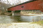
|
Waveland 39°56′N 87°05′W / 39.93°N 87.08°W |
Montgomery | 1947 | 3,082 acres (12.47 km2) | Only state park to ever have its own airstrip.[24] |
| Shakamak | 
|
Jasonville 39°10′N 87°14′W / 39.17°N 87.24°W |
Clay, Greene and Sullivan | 1929 | 1,766 acres (7.15 km2) | Used to be a strip mine[25] |
| Spring Mill | 
|
Mitchell 38°44′N 86°25′W / 38.73°N 86.42°W |
Lawrence | 1927 | 1,358 acres (5.50 km2) | Featured a pioneer village, numerous caves, and a memorial to Gus Grissom[26] |
| Summit Lake | 
|
New Castle 40°02′N 85°18′W / 40.03°N 85.30°W |
Henry | 1988 | 2,680 acres (10.8 km2) | [27] |
| Tippecanoe River | 
|
Winamac 41°09′N 86°36′W / 41.15°N 86.60°W |
Pulaski | 1943 | 2,761 acres (11.17 km2) | [28] |
| Turkey Run | 
|
Marshall 39°53′N 87°13′W / 39.88°N 87.21°W |
Parke | 1916 | 2,382 acres (9.64 km2) | Famous for its sandstone gorges and unique terrain[29] |
| Versailles | 
|
Versailles 39°05′N 85°14′W / 39.08°N 85.23°W |
Ripley | 1943 | 5,988 acres (24.23 km2) | [30] |
| White River | 
|
Indianapolis 39°46′N 86°10′W / 39.77°N 86.17°W |
Marion | 1979 | 250 acres (1.0 km2) | An urban park in downtown Indianapolis[31] |
| Whitewater Memorial | 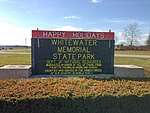
|
Liberty 39°37′N 84°58′W / 39.61°N 84.97°W |
Union | 1949 | 1,710 acres (6.9 km2) | Built on land donated by four counties[32] |

See also[]
- List of Indiana state forests
- List of National Parks of the United States
References[]
- ^ Jump up to: a b "DNR: State Parks: Find a Park". Indiana Department of Natural Resources. Retrieved March 28, 2010.
- ^ "White River State Park". in.gov. State of Indiana. Archived from the original on September 4, 2014. Retrieved September 3, 2014.
- ^ History Archived 2008-05-09 at the Wayback Machine
- ^ Ralston, Patrick. New Deal Resources in Indiana State Parks MPS
- ^ Ralston
- ^ DNR - State Parks & Reservoirs: History & Culture
- ^ Jump up to: a b "Indiana Recreation Guide 2010" (PDF). Indiana Department of Natural Resources. Archived from the original (PDF) on 17 February 2010. Retrieved 31 March 2010.
- ^ "Brown County". Indiana Department of Natural Resources. Retrieved 28 March 2010.
- ^ "Chain O' Lakes". Indiana Department of Natural Resources. Retrieved 28 March 2010.
- ^ "Charlestown". Indiana Department of Natural Resources. Retrieved 28 March 2010.
- ^ "Clifty Falls". Indiana Department of Natural Resources. Retrieved 28 March 2010.
- ^ "Falls of the Ohio". Indiana Department of Natural Resources. Retrieved 28 March 2010.
- ^ "Fort Harrison". Indiana Department of Natural Resources. Retrieved 28 March 2010.
- ^ "Harmonie". Indiana Department of Natural Resources. Retrieved 28 March 2010.
- ^ "Indiana Dunes". Indiana Department of Natural Resources. Retrieved 28 March 2010.
- ^ "Lincoln". Indiana Department of Natural Resources. Retrieved 28 March 2010.
- ^ "McCormick's Creek". Indiana Department of Natural Resources. Retrieved 28 March 2010.
- ^ "Mounds". Indiana Department of Natural Resources. Retrieved 28 March 2010.
- ^ "O'Bannon Woods". Indiana Department of Natural Resources. Retrieved 28 March 2010.
- ^ "Ouabache". Indiana Department of Natural Resources. Retrieved 28 March 2010.
- ^ "Pokagon". Indiana Department of Natural Resources. Retrieved 28 March 2010.
- ^ "Potato Creek". Indiana Department of Natural Resources. Retrieved 28 March 2010.
- ^ "Prophetstown". Indiana Department of Natural Resources. Retrieved 28 March 2010.
- ^ "Shades". Indiana Department of Natural Resources. Retrieved 28 March 2010.
- ^ "Shakamak". Indiana Department of Natural Resources. Retrieved 28 March 2010.
- ^ "Spring Mill". Indiana Department of Natural Resources. Retrieved 28 March 2010.
- ^ "Summit Lake". Indiana Department of Natural Resources. Retrieved 28 March 2010.
- ^ "Tippecanoe River". Indiana Department of Natural Resources. Retrieved 28 March 2010.
- ^ "Turkey Run". Indiana Department of Natural Resources. Retrieved 28 March 2010.
- ^ "Versailles". Indiana Department of Natural Resources. Retrieved 28 March 2010.
- ^ "White River". White River State Park. Retrieved March 28, 2010.
- ^ "Whitewater Memorial". Indiana Department of Natural Resources. Retrieved 28 March 2010.
External links[]
| Wikimedia Commons has media related to State parks of Indiana. |

| show Protected areas of Indiana |
|---|
- State parks of Indiana
- Lists of state parks of the United States
- Indiana geography-related lists