Cottonwoods, Manitoba
This article needs additional citations for verification. (December 2013) |
Cottonwoods | |
|---|---|
 Cottonwoods Location of Cottonwoods in Manitoba | |
| Coordinates: 49°50′59″N 99°42′0″W / 49.84972°N 99.70000°WCoordinates: 49°50′59″N 99°42′0″W / 49.84972°N 99.70000°W | |
| Country | |
| Province | |
| Region | Westman |
| Census Division | No. 7 |
| Government | |
| • Governing Body | Rural Municipality of Cornwallis Council |
| • MP | Larry Maguire |
| • MLA | Cliff Cullen |
| Time zone | UTC−6 (CST) |
| • Summer (DST) | UTC−5 (CDT) |
| Area code(s) | 204, 431 |
| NTS Map | 062G13 |
| GNBC Code | GAFOR |

Cottonwoods is an unincorporated community in southwestern Manitoba, Canada. It is located in the Rural Municipality of Cornwallis, approximately 18 kilometers (11 miles) east of Brandon.[1]
References[]
- ^ "Geographical Names of Canada - Querying Distances". nrcan.gc.ca. 2011-10-24. Archived from the original on 2013-04-10. Retrieved 2013-03-17.
| Cities | 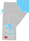 | ||
|---|---|---|---|
| Towns |
| ||
| Villages |
| ||
| Rural municipalities |
| ||
| Unincorporated communities | |||
This Manitoba location article is a stub. You can help Wikipedia by . |
Categories:
- Unincorporated communities in Manitoba
- Manitoba geography stubs