Brandon, Manitoba
Brandon | |
|---|---|
| City of Brandon | |
 From top left to right: Downtown Brandon, Brandon Court House, Dominion Exhibition Display Building II, Brandon Central Fire Station, Downtown Brandon, Assiniboine River, Brandon University | |
 Flag  Coat of arms | |
| Nickname(s): "Wheat City"[1] | |
| Motto(s): | |
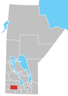
 Brandon Location of Brandon | |
| Coordinates: 49°50′54″N 099°57′00″W / 49.84833°N 99.95000°WCoordinates: 49°50′54″N 099°57′00″W / 49.84833°N 99.95000°W | |
| Country | Canada |
| Province | Manitoba |
| Region | Westman |
| Incorporated | 30 May 1882 |
| Government | |
| • Mayor | Rick Chrest |
| • Governing Body | Brandon City Council |
| • MLAs | Reg Helwer (PC) Len Isleifson (PC) Cliff Cullen (PC) |
| • MP | Larry Maguire (CPC) |
| Area | |
| • City | 77.41 km2 (29.89 sq mi) |
| • Urban | 76.89 km2 (29.69 sq mi) |
| • Metro | 2,289.33 km2 (883.92 sq mi) |
| Elevation | 409.40 m (1,343.18 ft) |
| Population (2016) | |
| • City | 48,859 (2nd) |
| • Density | 599.1/km2 (1,552/sq mi) |
| • Metro | 58,003 (58th) |
| • Metro density | 25.3/km2 (66/sq mi) |
| Time zone | UTC−06:00 (CST) |
| • Summer (DST) | UTC−05:00 (CDT) |
| Forward sortation area | R7A - R7C |
| Area code(s) | 204, 431 |
| Demonym | Brandonite, Brandonian |
| Website | City of Brandon |


Brandon is the second-largest city in the province of Manitoba, Canada. It is located in the southwestern corner of the province on the banks of the Assiniboine River, approximately 214 km (133 mi) west of the provincial capital, Winnipeg, and 120 km (75 mi) east of the Saskatchewan border. Brandon covers an area of 77.41 km2 (29.89 sq mi) and has a population of 48,859,[2] while its census metropolitan area has a population of 58,003.[3] It is the primary hub of trade and commerce for the Westman region as well as parts of southeastern Saskatchewan and northern North Dakota, an area with a combined population of over 180,000 people.[4]
The City of Brandon was incorporated in 1882,[5] having a history rooted in the Assiniboine River fur trade as well as its role as a major junction on the Canadian Pacific Railway.[6] Known as The Wheat City, Brandon's economy is predominantly associated with agriculture;[7] however, it also has strengths in health care, manufacturing, food processing, education, business services, and transportation.[8][9]
Brandon is an integral part of the higher education network in Manitoba, with several facilities located in the city including Brandon University, Assiniboine Community College, Robertson College, and the Manitoba Emergency Services College.[10] Canadian Forces Base Shilo is located 30 km (19 mi) east of Brandon and maintains close ties with the city.[11] Brandon's Keystone Centre, one of the largest consolidated entertainment, recreation, convention, and agriculture complexes in Canada,[12] is the home of the Brandon Wheat Kings and the Royal Manitoba Winter Fair.[13]
History[]
Prior to the influx of people from Eastern Canada, the area around Brandon was primarily used by the Sioux people, the Bungays, the Yellow Quills, and the Bird Tails.[14] In the 1870s and early 1880s, the Plains Bison were nearly wiped out by over-hunting. With the destruction of their staff of life, the buffalo, the nomadic Sioux people began to agree to settle in reservations such as the Sioux Valley Dakota Nation, or left the area entirely.
French Canadians also passed through the area on river boats on their way to the Hudson Bay Post, Fort Ellice located near present-day St. Lazare, Manitoba. The city of Brandon gets its name from the Blue Hills south of the city, which got their name from a Hudson's Bay trading post known as Brandon House, which got its name from a hill on an island in James Bay where Captain James had anchored his ship in 1631.[14]
During the 1870s it was believed by most that the transcontinental railway would take a northwesterly direction from Portage la Prairie. Many thought that the route would most likely go through either Minnedosa or Rapid City, Manitoba because they were both located at natural river crossings. Rapid City was the front runner for the site of the new railway and had prepared for the impending building boom accordingly. But suddenly, in 1881, the builders of the railway decided to take a more westerly route from Winnipeg, towards Grand Valley.[14] Grand Valley was located on the northern side of the Assiniboine, opposite the side of the river where present-day Brandon sits.
Grand Valley was originally settled by two brothers John and Dougal McVicar, and their families. With the expectation of the new railroad, settlers and prospectors now rushed to an area they had previously avoided.[14] Around 1879 a few settlers led by Reverend George Roddick had begun to build their new homes about 10 miles (16 km) south of Grand Valley, at the foot of the Brandon Hills.[14]

Meanwhile, in Grand Valley with the promise of the railway, the town began to boom. Regular voyages were made by steam sternwheelers to the city, each bringing more and more settlers.[14] In the spring of 1881, General Thomas L. Rosser, Chief Engineer of the Canadian Pacific Railway arrived in Grand Valley. It was Rosser's job to choose the townsites for the railway. Rosser approached Dougald McVicar of Grand Valley and offered him $25,000 for the railway in Grand Valley. McVicar countered with $50,000 to which Rosser replied that "I'll be damned if a town of any kind is ever built here".[14] So instead Rosser crossed the Assiniboine river and built the site of the railway on the high sandy south of the River, 2 miles (3.2 km) west of Grand Valley. So the site was then moved to a site just west of today's current First Street bridge in Brandon. A shanty had been built there by a man named J.D. Adamson, and it was on this quarter section Adamson claimed that Rosser chose as the townsite for the CPR Railway and named Brandon.[14]
After the location of the railway was once again changed, there was still hope that Grand Valley could become a rival neighbour to Brandon. But late in June 1881 it became clear that Grand Valley would not have lasted as a city long term. A flood hit in late June, and as the city was built on a low-lying part of the river, flooded quickly and dramatically.[14] Because Grand Valley was built on a low flood plain, and Brandon was built on the heights on the other side, it became apparent that Brandon was the best place for a city in the area.
Rosser had chosen Brandon as the townsite in May 1881, within a year settlers had flocked to Brandon in such numbers that it was incorporated as a city. Brandon never spent any time as a town or village but has only existed as a city.[14]
An Internment camp was set up at the Exhibition Building in Brandon from September 1914 to July 1916.[15] Post World War II, Brandon experience a minor disaster when an explosion at the Manitoba Power Commission's steam plant caused the 40 metre (130 ft) brick chimney to collapse, killing two workers in the process.[16]
In contemporary times, Brandon City Council elected its first female mayor when Shari Decter Hirst defeated incumbent Dave Burgess in the 2010 municipal election.[17]
Geography[]

Brandon is located in south-western Manitoba, on the banks of the Assiniboine river. It is located in the Canadian Prairies and resides in the aspen parkland ecoregion of the prairies.[18] The terrain is generally flat and rolling surrounding Brandon, and there is a large valley located within the city. The Brandon hills are located to the southeast, from which Brandon got its name. Brandon is 214 km (133 mi) from the provincial capital, Winnipeg; and 120 km (75 mi) from the Saskatchewan border.
Climate[]
Brandon has a dry continental climate (Köppen Dfb,[19] USDA Plant Hardiness Zone 2b[20]) with warm, sometimes hot summers and cold, dry winters. Daytime temperatures range from 26.0 °C (78.8 °F) in July to −10.5 °C (13.1 °F) in January. Brandon has a fairly dry climate, with 462 mm (18.2 in) of precipitation annually, and as such is located in the Palliser's Triangle region of the Prairies. There is measurable rainfall on 56.0 days throughout the year, and 38.8 days with snowfall. Snow falls from October to April; however, snow has fallen as late as May and as early as September. The highest temperature ever recorded in Brandon was 43.3 °C (110 °F) on 11 July 1936. The lowest temperature ever recorded was −46.7 °C (−52 °F) on 1 February 1893.[21]
General seasons
- Winter: November to March
- Spring: April to May
- Summer: June to August
- Fall: September to October
| hideClimate data for Brandon, 1981–2010 normals, extremes 1890–present | |||||||||||||
|---|---|---|---|---|---|---|---|---|---|---|---|---|---|
| Month | Jan | Feb | Mar | Apr | May | Jun | Jul | Aug | Sep | Oct | Nov | Dec | Year |
| Record high °C (°F) | 8.3 (46.9) |
15.0 (59.0) |
25.6 (78.1) |
36.0 (96.8) |
38.5 (101.3) |
42.2 (108.0) |
43.3 (109.9) |
41.1 (106.0) |
37.8 (100.0) |
32.5 (90.5) |
22.2 (72.0) |
14.4 (57.9) |
43.3 (109.9) |
| Average high °C (°F) | −10.5 (13.1) |
−7.1 (19.2) |
−0.3 (31.5) |
11.2 (52.2) |
18.7 (65.7) |
23.3 (73.9) |
26.0 (78.8) |
25.6 (78.1) |
19.3 (66.7) |
10.9 (51.6) |
−0.3 (31.5) |
−8.1 (17.4) |
9.1 (48.4) |
| Daily mean °C (°F) | −16.5 (2.3) |
−13.2 (8.2) |
−5.9 (21.4) |
4.5 (40.1) |
11.4 (52.5) |
16.6 (61.9) |
19.2 (66.6) |
18.2 (64.8) |
12.2 (54.0) |
4.6 (40.3) |
−5.4 (22.3) |
−13.6 (7.5) |
2.7 (36.9) |
| Average low °C (°F) | −22.4 (−8.3) |
−19.2 (−2.6) |
−11.4 (11.5) |
−2.3 (27.9) |
4.0 (39.2) |
9.9 (49.8) |
12.3 (54.1) |
10.8 (51.4) |
5.0 (41.0) |
−1.8 (28.8) |
−10.5 (13.1) |
−19.1 (−2.4) |
−3.7 (25.3) |
| Record low °C (°F) | −46.1 (−51.0) |
−46.7 (−52.1) |
−43.9 (−47.0) |
−27.8 (−18.0) |
−13.9 (7.0) |
−3.9 (25.0) |
0.0 (32.0) |
−3.3 (26.1) |
−11.7 (10.9) |
−26.5 (−15.7) |
−40.6 (−41.1) |
−43.0 (−45.4) |
−46.7 (−52.1) |
| Average precipitation mm (inches) | 17.9 (0.70) |
13.1 (0.52) |
24.7 (0.97) |
24.9 (0.98) |
56.5 (2.22) |
79.6 (3.13) |
68.2 (2.69) |
65.5 (2.58) |
41.9 (1.65) |
29.3 (1.15) |
18.9 (0.74) |
21.3 (0.84) |
461.7 (18.18) |
| Average rainfall mm (inches) | 0.1 (0.00) |
1.2 (0.05) |
8.0 (0.31) |
16.3 (0.64) |
52.1 (2.05) |
79.6 (3.13) |
68.2 (2.69) |
65.5 (2.58) |
41.6 (1.64) |
23.6 (0.93) |
3.8 (0.15) |
1.0 (0.04) |
360.8 (14.20) |
| Average snowfall cm (inches) | 17.6 (6.9) |
11.9 (4.7) |
16.9 (6.7) |
8.4 (3.3) |
4.5 (1.8) |
0.0 (0.0) |
0.0 (0.0) |
0.0 (0.0) |
0.3 (0.1) |
5.7 (2.2) |
15.1 (5.9) |
20.4 (8.0) |
100.8 (39.7) |
| Average precipitation days (≥ 0.2 mm) | 8.5 | 6.5 | 7.0 | 5.5 | 8.5 | 11.4 | 8.9 | 8.7 | 7.0 | 6.7 | 6.6 | 8.3 | 93.7 |
| Average rainy days (≥ 0.2 mm) | 0.04 | 0.48 | 1.5 | 3.5 | 7.9 | 11.4 | 8.9 | 8.7 | 6.9 | 5.2 | 1.1 | 0.35 | 56.0 |
| Average snowy days (≥ 0.2 cm) | 8.5 | 6.1 | 5.7 | 2.3 | 0.67 | 0.0 | 0.0 | 0.0 | 0.11 | 1.8 | 5.7 | 8.0 | 38.8 |
| Mean monthly sunshine hours | 99.3 | 131.3 | 180.2 | 234.6 | 272.7 | 271.9 | 306.6 | 300.0 | 210.6 | 163.5 | 96.3 | 91.6 | 2,358.5 |
| Percent possible sunshine | 37.2 | 46.2 | 49.0 | 56.9 | 57.2 | 55.7 | 62.3 | 66.9 | 55.5 | 48.9 | 35.3 | 36.1 | 50.6 |
| Source: Environment Canada (bright sunshine recorded at airport)[21][22] | |||||||||||||
Demographics[]
| Ethnic origins 2016 | ||
|---|---|---|
| Population | Percentage | |
| English | 13,585 | 28.6 |
| Scottish | 11,720 | 24.6 |
| Canadian | 10,650 | 22.4 |
| Irish | 8,210 | 17.3 |
| Ukrainian | 6,755 | 14.2 |
| German | 6,360 | 13.4 |
| French | 4,670 | 9.8 |
| First Nations | 4,025 | 8.5 |
| Polish | 3,110 | 6.5 |
| Métis | 2,795 | 5.9 |
According to the 2016 Census,[25] the population of Brandon is 48,859, a 6.1% increased from 2011, making it the second largest city in Manitoba. Brandon's land area is 77.41 km2 with a population density is 631.2 people per km2. The median age is 36.3 years old which is almost 5 years younger than the national average at 41.2 years old. There are 21,485 dwellings in Brandon with an occupancy rate of 94.3%, and the median cost of a dwelling at $264,781, much lower than the national average at $341,556.
As far as education goes, for those between 25 and 64 years old, 57.0% have a post-secondary schooling degree, 29.8% have a high school degree (or equivalent) and 13.2% have no certificates, diplomas or degrees. The unemployment rate is 7.3% in Brandon, lower than the national average at 7.7%. The median household income before taxes is $65,960, and after taxes at $57,008.
As of 2016, 88.8% of Brandon's residents are Canadian citizens. About 5.5% of residents are recent immigrants (from 2011 to 2016). Brandon is 70.1% white, 16.3% visible minorities and 13.6% aboriginal. The largest visible minority groups in Brandon are Latin American (5.0%), Chinese (3.8%), South Asian (3.0%), Black (2.1%) and Filipino (1.1%).
English is the mother tongue of 80.3% of residents. Other common first languages were Spanish (4.5%), Chinese Languages (3.2%) French (1.3%), Ukrainian (1.3%), Gujarati (1.2%), and German (1.2%).
Education[]

Public schools in Brandon are governed by the Brandon School Division #40. There are approximately 7200 students, 900 staff, 22 schools and a budget exceeding $50 million.[26] There are three high schools: Vincent Massey High School, Crocus Plains Regional Secondary School, and Neelin High School, as well as Neelin High School's Off-Campus learning centre. Brandon is also home to four post-secondary institutions: Brandon University, Assiniboine Community College, Robertson College, as well as the Manitoba Emergency Services College.
Sports[]

Local teams[]
- Brandon University Bobcats (Basketball/CWUAA)
- Brandon University Bobcats (Volleyball/CWUAA)
- Brandon Wheat Kings (Hockey/Western Hockey League)
- Wheat City Whiskey Jacks (Baseball/Expedition League)
Major events[]
- The Brier – Canadian Men's Curling Championship (1963, 1982, 2019)
- The Scott Tournament of Hearts – Canadian Women's Curling Championship (1993, 2002)
- World Curling Championship – Men's & Women's World Curling Championship (1995)
- Canadian Olympic Curling Trials – Men's & Women's Olympic Curling Trials (1997)
- Canada Winter Games – Canada Winter Games (1979)
- Canada Summer Games – Canada Summer Games (1997)
- Special Olympics Canada – Canada Special Olympics Summer Games (2006)
- Memorial Cup - MasterCard Memorial Cup (2010)
Sports venues[]
- Keystone Centre
- Brandon Community Sportsplex
- Andrews Field
Transportation[]

- Brandon is serviced by Brandon Municipal Airport.
- Rider Express provide intercity bus service from Regina and Winnipeg once a week, also Brandon Air Shuttle provide bus service from Winnipeg Airport 4 times a day.
- Taxi service is available from numerous local taxi companies.
- The city of Brandon runs Brandon Transit, which provides daily bus service throughout the city, with 10 routes that operate seven days a week.
- Brandon has a system of walking/bike trails throughout the city.
- The Canadian Pacific Railway runs through Brandon; the station is a historic landmark.[27]
- Cando Rail Services Ltd. is headquartered in Brandon.
Media[]
The Brandon Sun publishes daily newspapers.
Music and the arts[]

Brandon hosts many art festivals every year, including the Brandon Festival of the Arts, Brandon Jazz Festival, and the Brandon Folk Music Festival. In addition to the music festivals, the Brandon University School of Music hosts the annual 'Pro Series' which has included guests like Bob Brookmeyer, George Crumb, and the Winnipeg Symphony Orchestra. In 2009, Brandon hosted the Western Canadian Music Awards.
The "Words Alive" was a yearly literary festival held in downtown Brandon, from 2007-2010. Authors that participated in this festival included Robert J. Sawyer, Maggie Siggins, Fred Stenson and Corey Redekop.
Some of the local arts venues include the Western Manitoba Centennial Auditorium, Lorne Watson Recital Hall, Evans Theatre, and the Art Gallery of Southwestern Manitoba.
Events and exhibitions[]
- The Provincial Exhibition of Manitoba is a non-profit organization established in 1872, which is now housed at the city's extensive Keystone Centre complex. It hosts
- Royal Manitoba Winter Fair (March)
- Manitoba Summer Fair (June)
- Manitoba Livestock Expo (November)
- AgDays – Canada's largest indoor agricultural trade show and program, and one of the premier shows of its kind in North America. Held in mid January each year at Brandon's Keystone Centre.
- Brandon Folk Music and Arts Festival is a weekend event held annually in late July. The festival is held outdoors on the grounds of the Keystone Centre.
- The Commonwealth Air Training Plan Museum, located at the Brandon Municipal Airport.
Notable people[]
- William Otway Boger - WWI flying ace
- Turk Broda - ice hockey player
- Samuel Bronfman - businessman
- Kristen Campbell - ice hockey player
- James Ehnes – violinist
- Trent Frayne - sportswriter
- Glen Hanlon - ice hockey player
- Ron Hextall - ice hockey player
- Douglas Hill - science fiction author
- Keegan Kolesar - ice hockey player
- Kavavaow Mannomee - artist
- Daren Millard - sportscaster
- Kelsey Mitchell - cyclist
- Karl Schroeder - science fiction author
- Andrew Unger, writer
See also[]
- HMCS Brandon
- 26th Field Artillery Regiment, Royal Canadian Artillery
- St. Matthew's Anglican Cathedral, Brandon
References[]
- ^ "Enriching the Wheat City". Brandon Sun. Brandon Sun. 29 May 2012. Archived from the original on 26 February 2015.
- ^ Canada, Government of Canada, Statistics. "Focus on Geography Series, 2016 Census - Census subdivision of Brandon, CY (Manitoba)". www12.statcan.gc.ca. Archived from the original on 10 August 2017. Retrieved 28 April 2018.
- ^ Canada, Government of Canada, Statistics. "Focus on Geography Series, 2016 Census - Census agglomeration of Brandon". www12.statcan.gc.ca. Archived from the original on 10 August 2017. Retrieved 28 April 2018.
- ^ "Trading Area - Economic Development Brandon". Economic Development Brandon. Retrieved 12 February 2019.
- ^ "Brandon Chamber of Commerce - History of Brandon". www.brandonchamber.ca. Archived from the original on 23 April 2018. Retrieved 28 April 2018.
- ^ "History of Brandon - Economic Development Brandon". economicdevelopmentbrandon.com. Archived from the original on 1 December 2017. Retrieved 28 April 2018.
- ^ "Overview - Economic Development Brandon". economicdevelopmentbrandon.com. Archived from the original on 10 November 2017. Retrieved 28 April 2018.
- ^ "Economic Base - Economic Development Brandon". economicdevelopmentbrandon.com. Archived from the original on 1 December 2017. Retrieved 28 April 2018.
- ^ "Largest Employers - Economic Development Brandon". economicdevelopmentbrandon.com. Archived from the original on 1 December 2017. Retrieved 28 April 2018.
- ^ "Education & Training Institutions - Economic Development Brandon". economicdevelopmentbrandon.com. Archived from the original on 22 July 2017. Retrieved 28 April 2018.
- ^ "CFB Shilo Overview - Economic Development Brandon". economicdevelopmentbrandon.com. Archived from the original on 1 December 2017. Retrieved 28 April 2018.
- ^ "Event & Recreation Facilities - Economic Development Brandon". economicdevelopmentbrandon.com. Archived from the original on 1 December 2017. Retrieved 28 April 2018.
- ^ "Keystone Centre: Westman's Premier Event Facility". www.keystonecentre.com. Archived from the original on 24 February 2018. Retrieved 28 April 2018.
- ^ Jump up to: a b c d e f g h i j "History of Brandon". City of Brandon. Archived from the original on 6 July 2011. Retrieved 2 July 2010.
- ^ "Internment Camps in Canada during the First and Second World Wars, Library and Archives Canada". Archived from the original on 5 September 2014.
- ^ "Deadly 1957 explosion still echoes". Brandon Sun. 14 September 2017. Archived from the original on 17 September 2017.
- ^ "Meet your new city council". Brandon Sun. 28 October 2010. Archived from the original on 29 October 2010. Retrieved 28 October 2010.
- ^ "Aspen Parkland". University of Alberta. Archived from the original on 6 July 2011. Retrieved 5 July 2010.
- ^ "Updated world map of the Köppen-Geiger climate classification" (PDF). University of Melbourne. Archived (PDF) from the original on 3 February 2012. Retrieved 23 January 2013.
- ^ "Lawn and Garden: Brandon, MB". The Weather Network. Archived from the original on 26 December 2012. Retrieved 23 January 2013.
- ^ Jump up to: a b "Brandon CDA, Manitoba". Canadian Climate Normals 1981–2010. Environment Canada. Archived from the original on 8 May 2014. Retrieved 7 May 2014.
- ^ "Brandon A, Manitoba". Canadian Climate Normals 1981–2010. Environment Canada. Archived from the original on 8 May 2014. Retrieved 7 May 2014.
- ^ "Census Metro Profile, 2016 Census". Statistics Canada. Retrieved 9 June 2021.
- ^ "Population and Dwelling Counts, for Census Agglomerations in Alphabetical Order, 1991 and 1996". Statistics Canada. Retrieved 9 June 2021.
- ^ "Brandon, City [Census subdivision], Manitoba and Canada [Country] 2016 Census".
- ^ Brandon School Division#40 "Quick Facts" Archived 18 April 2009 at the Wayback Machine
- ^ Goldsborough, Gordon. "Historic Sites of Manitoba: Canadian Pacific Railway Station (1000 Pacific Avenue, Brandon)". www.mhs.mb.ca. Archived from the original on 6 March 2016. Retrieved 28 April 2018.
External links[]
| Wikisource has the text of the 1911 Encyclopædia Britannica article Brandon (Manitoba). |
| Wikimedia Commons has media related to Brandon, Manitoba. |
| Wikivoyage has a travel guide for Brandon, Manitoba. |
| show |
|---|
| show Authority control |
|---|
- Brandon, Manitoba
- Cities in Manitoba
- Hudson's Bay Company trading posts
- Populated places established in 1882