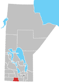
Somerset, Manitoba
This article needs additional citations for verification. (August 2012) |
Somerset | |
|---|---|
 | |
 Somerset Location of Somerset in Manitoba | |
| Coordinates: 49°24′44″N 98°39′38″W / 49.41222°N 98.66056°WCoordinates: 49°24′44″N 98°39′38″W / 49.41222°N 98.66056°W | |
| Country | |
| Province | |
| Region | Pembina Valley Region |
| Census Division | No. 4 |
| Established | 1889 |
| Incorporated | 1962 |
| Government | |
| • MP | Candice Bergen |
| • MLA | Blaine Pedersen |
| Time zone | UTC−6 (CST) |
| • Summer (DST) | UTC−5 (CDT) |
| Postal Code | R0G 2L0 |
| Area code(s) | 204 |
| NTS Map | 062G07 |
| GNBC Code | GAZTM |
Somerset is an unincorporated community recognized as a local urban district[2] in the Municipality of Lorne within the Canadian province of Manitoba that held village status prior to January 1, 2015. The community had a 2006 census population of 432 inhabitants, a decline of 5.9% from 459 during the 2001 census.
Somerset has a clinic, gas station, restaurant, two churches, a drive-in, a hotel, a grain elevator, a high school, a curling rink, a skating rink and a library. The community is also home to the large concrete plant, Boulet Brothers Concrete.
Climate[]
| Climate data for Somerset | |||||||||||||
|---|---|---|---|---|---|---|---|---|---|---|---|---|---|
| Month | Jan | Feb | Mar | Apr | May | Jun | Jul | Aug | Sep | Oct | Nov | Dec | Year |
| Record high °C (°F) | 6 (43) |
9 (48) |
16.1 (61.0) |
36.5 (97.7) |
37 (99) |
36 (97) |
36.7 (98.1) |
38.5 (101.3) |
36.7 (98.1) |
31.5 (88.7) |
22.2 (72.0) |
7 (45) |
38.5 (101.3) |
| Average high °C (°F) | −12.4 (9.7) |
−8.6 (16.5) |
−1.5 (29.3) |
9.6 (49.3) |
18.2 (64.8) |
22.3 (72.1) |
24.5 (76.1) |
24 (75) |
17.8 (64.0) |
10.2 (50.4) |
−1.5 (29.3) |
−10 (14) |
7.7 (45.9) |
| Daily mean °C (°F) | −17.3 (0.9) |
−13.8 (7.2) |
−6.5 (20.3) |
3.8 (38.8) |
11.5 (52.7) |
16.2 (61.2) |
18.4 (65.1) |
17.5 (63.5) |
11.7 (53.1) |
4.8 (40.6) |
−5.7 (21.7) |
−14.5 (5.9) |
2.2 (36.0) |
| Average low °C (°F) | −22.1 (−7.8) |
−18.7 (−1.7) |
−11.3 (11.7) |
−2.1 (28.2) |
4.7 (40.5) |
10 (50) |
12.2 (54.0) |
11 (52) |
5.5 (41.9) |
−0.7 (30.7) |
−9.9 (14.2) |
−18.9 (−2.0) |
−3.4 (25.9) |
| Record low °C (°F) | −40.5 (−40.9) |
−43 (−45) |
−35.6 (−32.1) |
−24.4 (−11.9) |
−10 (14) |
0 (32) |
1.5 (34.7) |
−2.5 (27.5) |
−6.1 (21.0) |
−20 (−4) |
−36 (−33) |
−39 (−38) |
−43 (−45) |
| Average precipitation mm (inches) | 21.7 (0.85) |
18.8 (0.74) |
29 (1.1) |
34.2 (1.35) |
56.1 (2.21) |
88.2 (3.47) |
82.6 (3.25) |
70.4 (2.77) |
58.2 (2.29) |
45.2 (1.78) |
36.2 (1.43) |
25.9 (1.02) |
536 (21.1) |
| Source: Environment Canada[3] | |||||||||||||
References[]
- ^ "Population and dwelling counts, for Canada and census subdivisions (municipalities), 2006 and 2001 censuses - 100% data". Statistics Canada, 2006 Census of Population. 2008-11-05. Retrieved 2009-01-30.
- ^ "Local Urban Districts Regulation". Government of Manitoba. April 23, 2016. Retrieved April 24, 2016.
- ^ "Canadian Climate Normals 1971–2000". Environment Canada. Retrieved 23 August 2012.
Categories:
- Designated places in Manitoba
- Former villages in Manitoba
- Local urban districts in Manitoba
- Pembina Valley Region
- Populated places disestablished in 2015
- 2015 disestablishments in Manitoba

