Cowley County, Kansas
Cowley County | |
|---|---|
County | |
 | |
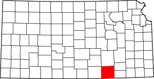 Location within the U.S. state of Kansas | |
 Kansas's location within the U.S. | |
| Coordinates: Coordinates: 37°14′N 96°50′W / 37.233°N 96.833°W | |
| Country | |
| State | |
| Founded | February 26, 1867 |
| Named for | Matthew Cowley |
| Seat | Winfield |
| Largest city | Arkansas City |
| Area | |
| • Total | 1,132 sq mi (2,930 km2) |
| • Land | 1,126 sq mi (2,920 km2) |
| • Water | 6.7 sq mi (17 km2) 0.6%% |
| Population | |
| • Total | 34,549 |
| • Density | 30.7/sq mi (11.9/km2) |
| Time zone | UTC−6 (Central) |
| • Summer (DST) | UTC−5 (CDT) |
| Area code | 620 |
| Congressional district | 4th |
| Website | cowleycounty.org |

Cowley County (county code CL) is a county located in the U.S. state of Kansas. As of the 2020 census, the county population was 34,549.[1] Its county seat is Winfield,[2] and its most populous city is Arkansas City.
History[]
For millennia, the land now known as Kansas was inhabited by Native Americans. The first European visitor to Kansas was the Spanish explorer Francisco Vasquez de Coronado in 1541. In 1601, the Governor of New Mexico, Juan de Oñate, visited Etzanoa, a settlement of several thousand Wichita people near Arkansas City along the Walnut River. The ruins of Etzanoa have been found by archaeologists.
19th century[]
In 1803, most of modern Kansas was secured by the United States as part of the Louisiana Purchase. In 1854, the Kansas Territory was organized, then in 1861 Kansas became the 34th U.S. state. Cowley County was officially organized as a county, but reserved for the Osage Indians, by the Kansas Legislature in March 1867, originally named Hunter County for Robert Mercer Taliaferro Hunter (1809–1887), a Virginia Representative and Senator to Congress and Speaker of the House in the twenty-sixth Congress. In 1870, the county was renamed for Matthew Cowley, First Lieutenant in Company I, 9th Kansas Cavalry, who died at Little Rock, Arkansas, on October 7, 1864. Officially opened for settlement July 15, 1870, there was a lengthy and bitter disagreement between the towns of Winfield and Cresswell (the town now named Arkansas City) over the possession of the county seat of government. Finally settled after two special elections and numerous petitions to the Governor and Legislature, Winfield was determined to be the county seat and a courthouse was constructed in 1873 at a cost of $11,500.[3]
21st century[]
In 2010, the Keystone-Cushing Pipeline (Phase II) was constructed north to south through Cowley County. Controversy arose from the Kansas legislature's decision to grant the pipeline a ten-year exemption from property taxes; it was estimated that this would mean $15 million per year in lost revenue to the six counties through which the pipeline passed. The counties were unsuccessful in an attempt to eliminate the exemption.[4][5][6][7]
Geography[]
According to the U.S. Census Bureau, the county has a total area of 1,132 square miles (2,930 km2), of which 1,126 square miles (2,920 km2) is land and 6.7 square miles (17 km2) (0.6%) is water.[8]
Adjacent counties[]
- Butler County (north)
- Elk County (northeast)
- Chautauqua County (east)
- Osage County, Oklahoma (south)
- Kay County, Oklahoma (southwest)
- Sumner County (west)
- Sedgwick County (northwest)
Demographics[]
| Historical population | |||
|---|---|---|---|
| Census | Pop. | %± | |
| 1860 | 158 | — | |
| 1870 | 1,175 | 643.7% | |
| 1880 | 21,538 | 1,733.0% | |
| 1890 | 34,478 | 60.1% | |
| 1900 | 30,156 | −12.5% | |
| 1910 | 31,790 | 5.4% | |
| 1920 | 35,155 | 10.6% | |
| 1930 | 40,903 | 16.4% | |
| 1940 | 38,139 | −6.8% | |
| 1950 | 36,905 | −3.2% | |
| 1960 | 37,861 | 2.6% | |
| 1970 | 35,012 | −7.5% | |
| 1980 | 36,824 | 5.2% | |
| 1990 | 36,915 | 0.2% | |
| 2000 | 36,291 | −1.7% | |
| 2010 | 36,311 | 0.1% | |
| 2020 | 34,549 | −4.9% | |
| U.S. Decennial Census[9] 1790-1960[10] 1900-1990[11] 1990-2000[12] 2010-2020[1] | |||
Cowley County comprises the Arkansas City-Winfield, KS Micropolitan Statistical Area, which is included in the Wichita-Arkansas City-Winfield, KS Combined Statistical Area.
As of the U.S. Census in 2000,[13] there were 36,291 people, 14,039 households, and 9,616 families residing in the county. The population density was 32 people per square mile (12/km2). There were 15,673 housing units at an average density of 14 per square mile (5/km2). The racial makeup of the county was 90.13% White, 2.70% Black or African American, 1.96% Native American, 1.53% Asian, 0.01% Pacific Islander, 1.36% from other races, and 2.30% from two or more races. Hispanic or Latino of any race were 3.59% of the population.
There were 14,039 households, out of which 32.20% had children under the age of 18 living with them, 55.20% were married couples living together, 9.60% had a female householder with no husband present, and 31.50% were non-families. 27.90% of all households were made up of individuals, and 13.20% had someone living alone who was 65 years of age or older. The average household size was 2.46 and the average family size was 3.00.
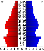
In the county, the population was spread out, with 26.00% under the age of 18, 9.90% from 18 to 24, 26.00% from 25 to 44, 22.20% from 45 to 64, and 15.90% who were 65 years of age or older. The median age was 37 years. For every 100 females, there were 95.70 males. For every 100 females age 18 and over, there were 94.20 males.
The median income for a household in the county was $34,406, and the median income for a family was $43,636. Males had a median income of $31,703 versus $21,341 for females. The per capita income for the county was $17,509. About 9.20% of families and 12.90% of the population were below the poverty line, including 17.00% of those under age 18 and 11.20% of those age 65 or over.
Government[]
Presidential elections[]
Laws[]
Following amendment to the Kansas Constitution in 1986, the county remained a prohibition, or "dry", county until 1996, when voters approved the sale of alcoholic liquor by the individual drink without a food sales requirement.[15]
Education[]
Colleges[]
- Cowley College
- Southwestern College
- St. John's College (closed in 1986)
Unified school districts[]
- Central USD 462
- Udall USD 463
- Winfield USD 465
- Arkansas City USD 470
- Dexter USD 471
Communities[]

Cities[]
- Winfield
- Arkansas City
- Udall
- Burden
- Parkerfield
- Dexter
- Atlanta
- Geuda Springs (partly in Sumner County)
- Cambridge
Unincorporated communities[]
- Akron
- Albright
- Box
- Cameron City
- Dale (Seely)
- Eaton
- Eschs
- Floral
- Glengrouse
- Grand Summit
- Hackney
- Hooser
- Kellogg
- Maple City
- Moxham
- New Salem
- Otto
- Pleasant Valley
- Rainbow Bend
- Redbud
- Rock
- Silverdale
- Taussig
- Tisdale
- Vinton
- Wilmot
Townships[]
Cowley County is divided into twenty-five townships. The cities of Arkansas City and Winfield are considered governmentally independent and are excluded from the census figures for the townships. In the following table, the population center is the largest city (or cities) included in that township's population total, if it is of a significant size.
Notable people[]
General Dean Coldwell Strother was a United States Air Force four-star general who served as U.S. Military Representative, NATO Military Committee (USMILREP), from 1962 to 1965; and as Commander in Chief, North American Air Defense Command/Commander in Chief, Continental Air Defense Command (CINCNORAD/CINCONAD), from 1965 to 1966.
Robert Docking was a successful banker and mayor of Arkansas City before he became the 38th Governor of Kansas.
Several college football head coaches have passed through Winfield that have gone on to become widely recognized. Jerry Kill is the current head coach for the Minnesota Golden Gophers—he played for the Southwestern Moundbuilders under Dennis Franchione when he was head coach. Jack Mitchell went on to coach several schools including the Kansas Jayhawks. Former head coach and for the Oklahoma Sooners and College Football Hall of Fame member Bennie Owen was born in Arkansas City.
Perhaps the most famous resident of Cowley County is the fictional character Mary Ann Summers from the television show Gilligan's Island. It is said on the show that she is "employed at the Winfield General Store."
See also[]
|
|
References[]
- ^ Jump up to: a b c "QuickFacts; Cowley County, Kansas; Population, Census, 2020 & 2010". United States Census Bureau. Archived from the original on August 15, 2021. Retrieved August 15, 2021.
- ^ "Find a County". National Association of Counties. Archived from the original on May 31, 2011. Retrieved June 7, 2011.
- ^ "William G. Cutler's, History of the State of Kansas". A. T. Andreas Press, 1883.[permanent dead link]
- ^ Davis, Dakotah. "Commissioners green light pipeline, sort of". Archived 2016-06-03 at the Wayback Machine NewsCow.net. Archived 2016-05-03 at the Wayback Machine May 19, 2010. Retrieved May 1, 2016.
- ^ "Counties to seek denial of pipeline tax exemption". Clay Center Dispatch. November 5, 2009. Archived December 16, 2009.
- ^ "Court upholds pipeline tax exemption". Topeka Capital-Journal. May 18, 2012. Retrieved May 1, 2016.
- ^ Milburn, John. "Kansas appeals court upholds Keystone pipeline tax ruling". Kansas City Star. April 26, 2013. Retrieved May 1, 2016.
- ^ "US Gazetteer files: 2010, 2000, and 1990". United States Census Bureau. February 12, 2011. Retrieved April 23, 2011.
- ^ "U.S. Decennial Census". United States Census Bureau. Retrieved July 22, 2014.
- ^ "Historical Census Browser". University of Virginia Library. Retrieved July 22, 2014.
- ^ "Population of Counties by Decennial Census: 1900 to 1990". United States Census Bureau. Retrieved July 22, 2014.
- ^ "Census 2000 PHC-T-4. Ranking Tables for Counties: 1990 and 2000" (PDF). United States Census Bureau. Retrieved July 22, 2014.
- ^ "U.S. Census website". United States Census Bureau. Retrieved January 31, 2008.
- ^ http://uselectionatlas.org/RESULTS
- ^ "Map of Wet and Dry Counties". Alcoholic Beverage Control, Kansas Department of Revenue. November 2006. Archived from the original on February 19, 2008. Retrieved December 28, 2007.
- Notes
- ^ These comprised 2,594 votes for Progressive Theodore Roosevelt (who carried the county) and 820 for Socialist Eugene V. Debs.
- ^ 3,896 of these votes were for Populist James B. Weaver (who was supported by the state’s Democrats) and 127 for Prohibition Party candidate John Bidwell.
Further reading[]
- History of Cowley County Kansas; D.A. Millington / E.P. Greer; Winfield Courier; 162 pages; 1901.
- Hand-book of Arkansas City and surroundings; C. S. Burch Publishing Co; 38 pages; 1887.
- Standard Atlas of Cowley County, Kansas; Geo. A. Ogle & Co; 54 pages; 1905.
- Historical Atlas of Cowley County, Kansas; John P. Edwards; 52 pages; 1882.
External links[]
| Wikimedia Commons has media related to Cowley County, Kansas. |
- County
- Historical
- Maps
- Cowley County Maps: Current, Historic, KDOT
- Kansas Highway Maps: Current, Historic, KDOT
- Kansas Railroad Maps: Current, 1996, 1915, KDOT and Kansas Historical Society
| show Places adjacent to Cowley County, Kansas |
|---|
| hide Municipalities and communities of Cowley County, Kansas, United States | ||
|---|---|---|
County seat: Winfield | ||
| Cities |  | |
| Unincorporated communities | ||
| Townships | ||
| Footnotes | †This populated place is designated a Census-Designated Place (CDP) by the United States Census Bureau. ‡This populated place also has portions in an adjacent county or counties. | |
| ||

| show Authority control |
|---|
- Kansas counties
- Cowley County, Kansas
- 1867 establishments in Kansas
- Wichita, KS Metropolitan Statistical Area
- Populated places established in 1867