Crail
Crail
| |
|---|---|
 | |
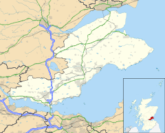 Crail Location within Fife | |
| Population | 1,630 [2] |
| OS grid reference | NO613078 |
| Council area | |
| Lieutenancy area | |
| Country | Scotland |
| Sovereign state | United Kingdom |
| Post town | ANSTRUTHER. |
| Postcode district | KY10 |
| Dialling code | 01333 |
| Police | Scotland |
| Fire | Scottish |
| Ambulance | Scottish |
| UK Parliament | |
| Scottish Parliament | |


Crail (![]() listen (help·info)); Scottish Gaelic: Cathair Aile) is a former royal burgh, parish and community council area (Royal Burgh of Crail and District) in the East Neuk of Fife, Scotland.
listen (help·info)); Scottish Gaelic: Cathair Aile) is a former royal burgh, parish and community council area (Royal Burgh of Crail and District) in the East Neuk of Fife, Scotland.
The locality has an estimated population of 1,630 (in 2018).[2]
Etymology[]
The name Crail was recorded in 1148 as Cherel and in 1153 as Karel.[4] The first element is the Pictish *cair (c.f. Welsh caer) meaning "fort",[4] though this word seems to have been borrowed into Gaelic.[4] The second element may be either Gaelic ail, "rocks",[4] or more problematically Pictish *al; no certain instance of this word exists in P-Celtic.[4] However, if the generic element were Pictish, then this is likely of the specific.[4]
History[]
The site on which the parish church is built appears to have religious associations that pre-date the parish church's foundation in early mediaeval times, as evidenced by an 8th century cross-slab preserved in the church.[5] The parish church was itself dedicated (in the 13th-century) to the early holy man St. Maelrubha of Applecross in Wester Ross.
Crail became a Royal Burgh in 1178 in the reign of King William the Lion.[6] Robert the Bruce granted permission to hold markets on a Sunday.[5]
Mary of Guise, afterwards consort of James V, landed in Crail in June 1538 after a severe storm, and was hospitably entertained in the ancient mansion of Balcomie Castle, whence, accompanied by the king, she proceeded to St. Andrew's.[7]
John Knox, visiting Crail on his way to St Andrews in 1559, was moved to deliver a sermon in Crail Parish Church. Afterwards protesters went through the church and forcefully removed images which were put in place by previous generations but were now considered ideologically unsound.[8] In August 1583 many of the inhabitants of Crail attacked nearby Wormiston House, which belonged to Sir John Anstruther. They filled up newly made ponds and ditches, and destroyed a plantation of ash trees. They were angry at Sir John because his new ditches had been built on land they claimed to belong to them as common land. The Privy Council of Scotland ordered them to rebuild the dykes.[9]
In 2017 The Community Council was granted the Letters Patent to the Crail Shield and Coat of Arms.[3] This was lost when the Royal Burgh of Crail Council was abolished in 1976.
Architecture[]

Built around a harbour, Crail has a particular wealth of vernacular buildings from the 17th to early 19th centuries, many restored by the National Trust for Scotland, and is a favourite subject for artists.[citation needed]
The most notable building in the town is the parish church, situated in the Marketgate - from the mid 13th century St Maelrubha's, in later medieval times St Mary's, but now, as part of the Church of Scotland's ministry, known just as Crail Parish Church. It was founded in the second half of the 12th century. From early in its history it belonged to the Cistercian Nunnery of St Clare in Haddington and remained the Nunnery's possession until the Reformation.[10]
Though much altered, this is one of Scotland's most beautiful ancient churches.[citation needed] According to Crail Parish Church's website (see external link below) in its first form the church building consisted of an unaisled rectangular nave and chancel of romanesque design. In the early 13th century a fine western tower with small spire was added, and a double arcade of round pillars of variegated red sandstone in the nave. It was in this form in 1243 that the church was dedicated to St Maelrubha by the Bishop of St Andrews. (In later times it was known as St Mary's probably after a later dedication in a later period that disliked vestiges of the Celtic Church.) The side walls were rebuilt in Regency times, and the large pointed windows, filled with panes of clear glass held by astragals rather than leads, allow light to flood into the interior. The unaisled chancel, now housing a huge organ, has been shortened. The church retains some 17th-century woodwork. The early Christian cross-slab mentioned at the start of this article is on display in the church: it is of unusual form (perhaps 10th century), formerly set in the floor. The church building is open on some afternoons in the summer.
The large Kirkyard surrounding the building has a fine collection of monuments and stones dating from the late 16th century onwards and an unusual ornamented morthouse is present, once used to frustrate the activities of bodysnatchers.
Other historic buildings in Crail include the doo'cot (Scots for dovecot) of the town's otherwise vanished Franciscan Friary.
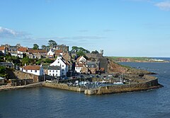
Crail once had a royal castle above the harbour (perhaps this was the site of the 'fort'). The site is still visible as an open garden attached, but little or nothing of the structure survives above ground. A Victorian 'turret' jutting out from the garden wall recalls the Castle (visible in the photograph reproduced above, in the infobox).
The Tolbooth is near the juncture of Tolbooth Wynd and the Marketgate. It stands on its own at the edge of the large marketplace with its mercat cross in the centre of the town - this is where the Sunday markets were once held. (The former marketplace is now used as a car park.) The Tolbooth has a characteristic tower dating from about 1600 and a European style roof, similar to buildings in Holland. The weathervane on the spire is in the form of a smoked haddock (known locally as a Crail Capon) rather than the traditional cockerel form.[6] The curved roof form on the tower evidences the European influence of the 16th century, and is architecturally described as a Dutch spire (several other contemporary examples exist in Scotland). The bell inside was cast in Holland and bears the date 1520, and is a permanent reminder of the town’s trading links with the Dutch.
The Crail Museum and Heritage Centre, largely staffed by volunteers and open every day in summer, is sited in a neighbouring building, also of historical interest, at the top of Tolbooth Wynd. (See external link below.) It houses temporary exhibitions and has a permanent exhibition on HMS Jackdaw. On permanent display in the Burgh Room is the ceremonial robe worn by the provost of the Burgh of Crail before the reorganisation of local government in Scotland in 1975. (Before 1975 each Scottish burgh was governed by a town council headed by a provost.) Entry to Crail Museum is free but donations are accepted. On Sunday afternoons in summer the museum is the leaving point for guided tours of Crail, led by volunteer guides.
The Customs House on the Shoregate dates from the 17th century.
Parish Church[]
Crail Church probably dates from the foundation of the village but the oldest remaining element is the west tower of c. 1220. The church was dedicated to St Maelrubha of Applecross in 1243 by the Bishop of St Andrews. It was rededicated to St Mary in or before 1517 when it was raised to a collegiate church by its superior, the Prioress of Haddington. It was extended soon after this and an octagonal stone spire added. From 1594 its presumably substantial income was divided in three: one third for the minister of Crail and upkeep of the church, one third to students of divinity at St Andrews University and one third to philosophy students at Edinburgh University. The interior was laid out per trades and would have had altars to each trade pre-Reformation. Much survived the rebuilding programmes of the early 1th[clarification needed] century but the restoration of 1963 lost much original timberwork.[11]
The churchyard includes a war memorial gateway of 1921.
Harbour[]

The eastern pier, hooking round to the south, is known to have been substantially complete by 1583. In 1610 it is described as "new foundit" (newly built). However in 1707 it is called "old and ruinous", requiring rebuilding.[12]
The west pier was rebuilt in 1828 by Robert Stevenson. This work incorporated the crane on the southwest corner which lifts timbers into slots to seal the inner harbour.[6][13]
The structure of the inner walls of the harbour features a highly unusual vertical coursing of the stones.
Notable residents[]
- Andrew Duncan minister exiled for opposing the policies of James VI ( c1560 – 1626)
- James Sharp (bishop), became Archbishop of St Andrews (1618 – 1679)
- James Oswald (composer) (1710-1769)
- William Dickson, footballer (1866-1910)
- Oswald Wynd, author (1913–1998)
- Joan Clarke, cryptanalyst and former fiancée of Alan Turing (1917 – 1996)
Carboniferous fossils[]
On the beach beside the harbour, there are fossilised trees related to Horsetails, dating back to the Carboniferous geological period.
Sport[]
The Crail Golfing Society is the seventh oldest in the world, formed in 1786. Their oldest course, Balcomie, was formally laid out by Tom Morris Sr. in 1894, but competitions had been played there since the 1850s.
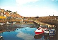
Gallery[]
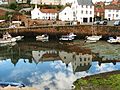
Crail Harbour

House near the harbour
Crail Harbour

Viewing the harbour from above

Boats in Crail Harbour


References[]
- Citations
- ^ Iomart Cholm Cille
- ^ Jump up to: a b CP, pg263 Localities.
- ^ Jump up to: a b Conolly 1869, pg263.
- ^ Jump up to: a b c d e f Taylor, Simon. "Crail". Fife Place-name Data. Retrieved 10 September 2019.
- ^ Jump up to: a b "Crail: Overview". Gazetteer for Scotland. Retrieved 12 December 2018.
- ^ Jump up to: a b c Scottish Seaside Towns, by Brian Edwards ISBN 0-563-20452-4
- ^ Lewis 1851, 235.
- ^ Wood 1887, 48.
- ^ Masson 1880.
- ^ Scott 1925, pg191.
- ^ Buildings of Scotland: Fife p135/6 by John Gifford
- ^ Buildings of Scotland: Fife p.137 by John Gifford
- ^ "Engineering Timelines - Robert Stevenson". www.engineering-timelines.com.
- Sources
- Bell, Andrew (1793). The Statistical Account of Scotland. 9. Edinburgh : Printed and sold by William Creech; and also sold by J. Donaldson, and A. Guthrie, Edinburgh; T. Cadell, J. Stockdale, J. Debrett, and J. Sewel, London; Dunlop and Wilson, Glasgow; Angus and Son, Aberdeen. pp. 439–458.
- "Crail". City Population. Retrieved 15 August 2020.
- Conolly, Matthew Forster (1869). Fifiana, or, Memorials of the east of Fife. Glasgow: John Tweed.
- Groome, Francis, Hindes (1882). "Crail". Ordnance gazetteer of Scotland : a survey of Scottish topography, statistical, biographical, and historical. 2. Edinburgh: T.C. Jack. pp. 299-300.
- Lewis, Samuel (1851). "Crail". A topographical dictionary of Scotland, comprising the several counties, islands, cities, burgh and market towns, parishes, and principal villages, with historical and statistical descriptions: embellished with engravings of the seals and arms of the different burghs and universities. 1. London: S. Lewis and co. pp. 235-236.
- Masson, David, ed. (1880). "The register of the Privy Council of Scotland (1578-1585)". 3. 4. Edinburgh: H.M. General Register House: p616. Cite journal requires
|journal=(help) - Merson, William (1845). The New Statistical Account of Scotland. 9. Edinburgh and London: William Blackwood and Sons. pp. 941–969.
- Rogers, Charles (1877). Register of the Collegiate Church of Crail. London: Grampian Club.
- Scott, Hew (1925). Fasti ecclesiae scoticanae; the succession of ministers in the Church of Scotland from the reformation. 5. Edinburgh: Oliver and Boyd. pp. 191-195.
- Wood, Walter (1887). Brown, J. Wood (ed.). The East Neuk of Fife: its history and antiquities. Edinburgh: D. Douglas.
External links[]
| Wikimedia Commons has media related to Crail. |
- Crail Parish Church
- The Royal Burgh of Crail and District Community Council
- The Golf Hotel - one of Scotland's oldest coaching inns
- Crail Matters: Crail's weekly newsletter published Monday morning
- Crail Pottery
- Crail Museum & Heritage Centre
- Crail Golfing Society
- History of Crail Timeline
- Crail Raceway
- The Crail Gallery
- The Jerdan Gallery
- Crail Harbour Gallery & Tearoom
- Julias Cafe & Gifts
- Honeypot Guest Rooms & Coffee House
- Longskerries Holiday Cottage
| hide Authority control | |
|---|---|
| General | |
| National libraries | |
- Crail
- Towns in Fife
- Royal burghs
- Parishes in Fife