Credera Rubbiano
Credera Rubbiano
Credéra Rübià (Lombard) | |
|---|---|
| Comune di Credera Rubbiano | |
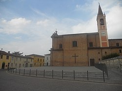 A square in Credera Rubbiano. | |
Location of Credera Rubbiano  | |
 Credera Rubbiano Location of Credera Rubbiano in Italy | |
| Coordinates: 45°18′N 9°40′E / 45.300°N 9.667°ECoordinates: 45°18′N 9°40′E / 45.300°N 9.667°E | |
| Country | Italy |
| Region | Lombardy |
| Province | Cremona (CR) |
| Government | |
| • Mayor | Matteo Guerini Rocco |
| Area | |
| • Total | 14.4 km2 (5.6 sq mi) |
| Elevation | 69 m (226 ft) |
| Population (30 June 2017)[3] | |
| • Total | 1,605 |
| • Density | 110/km2 (290/sq mi) |
| Demonym(s) | Crederesi |
| Time zone | UTC+1 (CET) |
| • Summer (DST) | UTC+2 (CEST) |
| Postal code | 26010 |
| Dialing code | 0373 |
| Website | Official website |


Credera Rubbiano (Cremasco: Credéra Rübià) is a comune (municipality) in the Province of Cremona in the Italian region Lombardy, located about 45 kilometres (28 mi) southeast of Milan and about 35 kilometres (22 mi) northwest of Cremona. It was created in 1928 through the merger of the former communes of Credera and Rubbiano.
Credera Rubbiano borders the following municipalities: Capergnanica, Casaletto Ceredano, Cavenago d'Adda, Moscazzano, Ripalta Cremasca, Turano Lodigiano.
References[]
- ^ "Superficie di Comuni Province e Regioni italiane al 9 ottobre 2011". Italian National Institute of Statistics. Retrieved 16 March 2019.
- ^ "Popolazione Residente al 1° Gennaio 2018". Italian National Institute of Statistics. Retrieved 16 March 2019.
- ^ All demographics and other statistics: Italian statistical institute Istat.
This article on a location in the Province of Cremona is a stub. You can help Wikipedia by . |
Categories:
- Cities and towns in Lombardy
- Municipalities of the Province of Cremona
- Province of Cremona geography stubs