Genivolta
Genivolta
Geniólta (Lombard) | |
|---|---|
| Comune di Genivolta | |
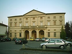 Villa Settala, the current town hall. | |
 Coat of arms | |
show Location of Genivolta | |
 Genivolta Location of Genivolta in Italy | |
| Coordinates: 45°20′N 9°53′E / 45.333°N 9.883°E | |
| Country | Italy |
| Region | Lombardy |
| Province | Cremona (CR) |
| Government | |
| • Mayor | Giampaolo Lazzari |
| Area | |
| • Total | 18.7 km2 (7.2 sq mi) |
| Elevation | 70 m (230 ft) |
| Population | |
| • Total | 1,182 |
| • Density | 63/km2 (160/sq mi) |
| Demonym(s) | Genivoltesi |
| Time zone | UTC+1 (CET) |
| • Summer (DST) | UTC+2 (CEST) |
| Postal code | 26020 |
| Dialing code | 0374 |
| Patron saint | St. Lawrence |
| Saint day | 10 August |
| Website | Official website |


Genivolta (Soresinese: Geniólta) is a comune (municipality) in the Province of Cremona in the Italian region Lombardy, located about 60 kilometres (37 mi) east of Milan and about 25 kilometres (16 mi) northwest of Cremona.
Genivolta borders the following municipalities: Azzanello, Casalmorano, Cumignano sul Naviglio, Soncino, Soresina, Villachiara.
References[]
- ^ "Superficie di Comuni Province e Regioni italiane al 9 ottobre 2011". Istat. Retrieved 16 March 2019.
- ^ "Popolazione Residente al 1° Gennaio 2018". Istat. Retrieved 16 March 2019.
- ^ All demographics and other statistics: Italian statistical institute Istat.
| show Authority control |
|---|
This article on a location in the Province of Cremona is a stub. You can help Wikipedia by . |
Categories:
- Cities and towns in Lombardy
- Municipalities of the Province of Cremona
- Province of Cremona geography stubs