Cucao and Huillinco
| Cucao and Huillicno Lake Lago Cucao y Huillinco | |
|---|---|
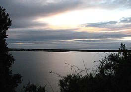 View of Cucao Lake | |
 Cucao and Huillicno Lake Lago Cucao y Huillinco | |
| Coordinates | 42°38′20.40″S 74°3′59.08″W / 42.6390000°S 74.0664111°WCoordinates: 42°38′20.40″S 74°3′59.08″W / 42.6390000°S 74.0664111°W |
| Primary outflows | Cucao River, also called Desaguadero River |
| Basin countries | Chile |
| Surface area | 43.8 km2 (16.9 sq mi) |

Cucao and Huillinco are two lakes in central Chiloé Island, Chile, linked by a strait forming one hydrologic lake. The two lakes are oriented in west-east fashion cutting off the Chilean Coast Range in Chiloé Island into two ranges; Piuchén to north and Pirulil to the south. The outlet of the lakes, Desaguadero or Cucao River lies at the western end of Cucao Lake, and flows into the Pacific.
| Main islands |  | ||||||||
|---|---|---|---|---|---|---|---|---|---|
| Water bodies | |||||||||
| Cities and towns | |||||||||
| History |
| ||||||||
| Culture |
| ||||||||
1: These islands are not part of Chiloé Province | |||||||||
This Los Lagos Region location article is a stub. You can help Wikipedia by . |
Categories:
- Lakes of Chile
- Lakes of Los Lagos Region
- Los Lagos Region geography stubs