Cure (river)
| Cure | |
|---|---|
 | |
 | |
| Location | |
| Country | France |
| Physical characteristics | |
| Source | |
| • location | Morvan |
| Mouth | |
• location | Yonne |
• coordinates | 47°40′31″N 3°41′19″E / 47.67528°N 3.68861°ECoordinates: 47°40′31″N 3°41′19″E / 47.67528°N 3.68861°E |
| Length | 113 km (70 mi) |
| Basin features | |
| Progression | Yonne→ Seine→ English Channel |

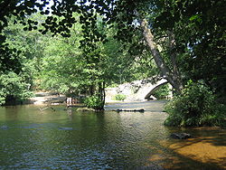
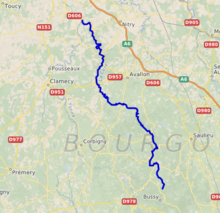
The Cure is a 113 km (70 mi) long river in central France, a right-bank tributary of the Yonne.[1] Its source is in Gien-sur-Cure, in the Morvan hills. It flows into the Yonne at Cravant near Vermenton.
Communes crossed[]
It crosses the following departments and towns: (from its source to its confluence):
- Anost (source, Saône-et-Loire)
- Planchez (Nièvre)
- Gien-sur-Cure (Nièvre)
- Moux-en-Morvan (lac des Settons, Nièvre)
- Montsauche-les-Settons (lac des Settons, Nièvre)
- Gouloux (Nièvre)
- Saint-Brisson (Nièvre)
- Dun-les-Places (Nièvre)
- Quarré-les-Tombes (Yonne)
- Marigny-l'Eglise (lac du Crescent, Nièvre)
- Saint-Germain-des-Champs (Yonne)
- Chastellux-sur-Cure (Yonne)
- Saint-André-en-Morvan (Nièvre)
- Domecy-sur-Cure (Yonne)
- Pierre-Perthuis (Yonne)
- Foissy-les-Vezelay (Yonne)
- Saint-Père (near Vézelay, Yonne)
- Asquins (Yonne)
- Montillot (Yonne)
- Givry (Yonne)
- Blannay (Yonne)
- Sermizelles (Yonne)
- Voutenay-sur-Cure (Yonne)
- Saint-Moré (Yonne)
- Arcy-sur-Cure (Yonne)
- Bessy-sur-Cure (Yonne)
- Lucy-sur-Cure (Yonne)
- Vermenton (Yonne)
- Accolay (Yonne)
- Cravant (Yonne)
References[]
External links[]
| hide Authority control | |
|---|---|
| General |
|
| National libraries | |
This Bourgogne-Franche-Comté geographical article is a stub. You can help Wikipedia by . |
Categories:
- Tributaries of the Yonne
- Rivers of France
- Rivers of Bourgogne-Franche-Comté
- Rivers of Nièvre
- Rivers of Yonne
- Bourgogne-Franche-Comté geography stubs
- France river stubs