Saint-Père, Yonne
Saint-Père | |
|---|---|
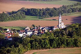 A general view of Saint-Père | |
show Location of Saint-Père | |
 Saint-Père | |
| Coordinates: 47°27′38″N 3°45′57″E / 47.4606°N 3.7658°ECoordinates: 47°27′38″N 3°45′57″E / 47.4606°N 3.7658°E | |
| Country | France |
| Region | Bourgogne-Franche-Comté |
| Department | Yonne |
| Arrondissement | Avallon |
| Canton | Joux-la-Ville |
| Area 1 | 15.28 km2 (5.90 sq mi) |
| Population (Jan. 2018)[1] | 303 |
| • Density | 20/km2 (51/sq mi) |
| Time zone | UTC+01:00 (CET) |
| • Summer (DST) | UTC+02:00 (CEST) |
| INSEE/Postal code | 89364 /89450 |
| Elevation | 142–359 m (466–1,178 ft) |
| 1 French Land Register data, which excludes lakes, ponds, glaciers > 1 km2 (0.386 sq mi or 247 acres) and river estuaries. | |


Saint-Père is a commune in the Yonne department in Bourgogne-Franche-Comté in north-central France.
See also[]
References[]
- ^ "Populations légales 2018". INSEE. 28 December 2020.
| Wikimedia Commons has media related to Saint-Père (Yonne). |
| show Authority control |
|---|
This Yonne geographical article is a stub. You can help Wikipedia by . |
Categories:
- Communes of Yonne
- Yonne geography stubs