Sougères-en-Puisaye
Sougères-en-Puisaye | |
|---|---|
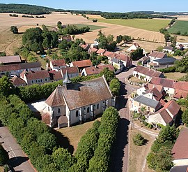 Aerial view of Sougères-en-Puisaye (2018). | |
 Coat of arms | |
show Location of Sougères-en-Puisaye | |
 Sougères-en-Puisaye | |
| Coordinates: 47°33′35″N 3°19′45″E / 47.5597°N 3.3292°ECoordinates: 47°33′35″N 3°19′45″E / 47.5597°N 3.3292°E | |
| Country | France |
| Region | Bourgogne-Franche-Comté |
| Department | Yonne |
| Arrondissement | Auxerre |
| Canton | Vincelles |
| Government | |
| • Mayor (2020-2026) | Mireille Lhote |
| Area 1 | 26.50 km2 (10.23 sq mi) |
| Population (Jan. 2018)[1] | 317 |
| • Density | 12/km2 (31/sq mi) |
| Time zone | UTC+01:00 (CET) |
| • Summer (DST) | UTC+02:00 (CEST) |
| INSEE/Postal code | 89400 /89520 |
| Elevation | 193–352 m (633–1,155 ft) |
| 1 French Land Register data, which excludes lakes, ponds, glaciers > 1 km2 (0.386 sq mi or 247 acres) and river estuaries. | |


Sougères-en-Puisaye is a commune in the Yonne department in Bourgogne-Franche-Comté in north-central France, in the natural region of Forterre - even though its name refers to neighboring Puisaye.
Inhabitants are "Sougérois" and "Sougéroise".
Geography[]
Sougères-en-Puisaye has few hamlets: "Les Simons" (close to the village), "Chauminet", "Pesselières", "Les Billards" and "Les Roches".
See also[]
References[]
- ^ "Populations légales 2018". INSEE. 28 December 2020.
External links[]
| Wikimedia Commons has media related to Sougères-en-Puisaye. |
This Yonne geographical article is a stub. You can help Wikipedia by . |
Categories:
- Communes of Yonne
- Yonne geography stubs