Cutler Formation
| Cutler Formation Stratigraphic range: Cisuralian | |
|---|---|
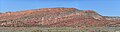
 Cutler Formation near the type locality, Portland, Ouray County, Colorado | |
| Type | Geological formation |
| Sub-units | De Chelly Sandstone, White Rim Sandstone, Organ Rock Shale, Cedar Mesa Sandstone, Elephant Canyon Formation, Halgaito Shale[1][2] |
| Underlies | Chinle Formation |
| Lithology | |
| Primary | Iron-rich arkose sandstone |
| Location | |
| Coordinates | 38°05′46″N 107°42′07″W / 38.096°N 107.702°WCoordinates: 38°05′46″N 107°42′07″W / 38.096°N 107.702°W |
| Approximate paleocoordinates | 0°42′N 36°06′W / 0.7°N 36.1°W |
| Region | Colorado Plateau |
| Country | United States |
| Extent | Arizona Colorado New Mexico Utah |
| Type section | |
| Named for | Cutler Creek, north of Ouray, Co |
| Named by | Cross & Howe |
| Year defined | 1905 |
 Cutler Formation (the United States) | |


The Cutler Formation or Cutler Group is a rock unit that is spread across the U.S. states of Arizona, northwest New Mexico, southeast Utah and southwest Colorado. It was laid down in the Early Permian during the Wolfcampian stage. Its subunits, therefore, are variously called formations or members depending on the publication. Members (youngest to oldest):[1][2]
- De Chelly Sandstone (Arizona, Colorado, New Mexico, Utah)
- White Rim Sandstone (Utah)
- Organ Rock Shale (Arizona, Colorado, New Mexico, Utah)
- Cedar Mesa Sandstone (Arizona, Utah)
- Elephant Canyon Formation (Utah)
- Halgaito Shale (Arizona, Colorado, New Mexico, Utah)-(oldest)
In addition, beds formerly assigned to the Rico Formation are now included in the lower Cutler Group.[3]
Extent[]
There is no designated type locality for the Cutler. It was named by Cross and Howe in 1905 after Cutler Creek, which enters Uncompahgre River about 4 miles north of Ouray, Colorado.[4] Baker and Reeside revised Cross and Howe's work in 1929 by dividing the formation into the Halgaito Tongue (base), Cedar Mesa Sandstone Member, Organ Rock Tongue, and White Rim Sandstone Member. Cutler's geographic extent was established by Wood and Northrop in 1946. In 1958 Wengerd and Matheny raised the formation to group rank.
Cutler and Chinle formations in Lisbon Valley, San Juan County, Utah
Cedar Mesa Sandstone overlaying Organ Rock Shale, Canyonlands, Utah

Geology[]
Cutler outcrops are found in these geologic locations in Arizona, Colorado, New Mexico and Utah.
- Black Mesa Basin
- Paradox Basin
- Piceance Basin
- San Juan Mountains province
- San Juan Basin
- Uinta Basin
References[]
- ^ Jump up to: a b "Geology of Canyonlands National Park" (PDF). National Park Service, U.S. Department of the Interior. Retrieved 30 September 2018.
- ^ Jump up to: a b "Stratigraphy of Canyon de Chelly National Monument". Geology of National Parks, 3D and Photographic Tours. United States Geological Survey. Archived from the original on 1 October 2018. Retrieved 30 September 2018.
- ^ Loope, David B.; Sanderson, George A.; Verville, George J. (October 1990). "Abandonment of the name "Elephant Canyon Formation" in southeastern Utah: Physical and temporal implications". The Mountain Geologist. 27 (4): 119–130. Retrieved 27 July 2021.
- ^ Keroher, Grace C., Lexicon of Geologic Names of the United States for 1936-1960, Part 1, p. 1019, at Google Books
Bibliography[]
- Cross, C.W. and Howe, Ernest, 1905, "Geography and general geology of the quadrangle, IN Description of the Silverton quadrangle [Colorado]", U.S. Geological Survey Geologic Atlas of the United States, Silverton folio, no. 120, 34 p.
- Baker, A.A. and Reeside, J.B., Jr., 1929, "Correlation of the Permian of southern Utah, northern Arizona, northwestern New Mexico, and southwestern Colorado", American Association of Petroleum Geologists Bulletin, v. 13, no. 11, p. 1413-1448
- Wood, G.H. and Northrop, S.A., 1946, "Geology of Nacimiento Mountains, San Pedro Mountain, and adjacent plateaus in parts of Sandoval and Rio Arriba Counties, New Mexico", U.S. Geological Survey Oil and Gas Investigations Map, OM-57, 1 sheet, scale 1:95,040
- Wengerd, S.A. and Matheny, M.L., 1958, "Pennsylvanian system of the Four Corners region", American Association of Petroleum Geologists Bulletin, v. 42, no. 9, p. 2048-2106
External links[]
- Cutler Formation
- Geologic formations of Arizona
- Geologic formations of Colorado
- Geologic formations of Utah
- Permian Arizona
- Permian Colorado
- Permian formations of New Mexico
- Permian geology of Utah
- Cisuralian Series of North America
- Sandstone formations of the United States
- Fluvial deposits
- Lacustrine deposits
- Permian northern paleotropical deposits
- Paleontology in Colorado
- Paleontology in New Mexico
- Paleontology in Utah