Dadu District
Dadu District
ضلعو دادو | |
|---|---|
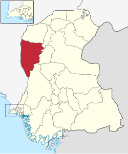 Dadu is located in the east of Sindh | |
| Country | |
| Province | |
| Headquarters | Dadu |
| • District Nazim | (ISF) |
| Area | |
| • Total | 7,866 km2 (3,037 sq mi) |
| Population (2017)[1] | |
| • Total | 1,550,266 |
| • Density | 200/km2 (510/sq mi) |
| Time zone | UTC+5 (PST) |
| Area code(s) | 025 |
| Number of Tehsils | 4 |
Dadu District (Sindhi: دادو), (Urdu: دادو) is a district of Sindh Province, Pakistan. With headquarters the city of Dadu, the district was created in 1931[2][3] by merging Kotri and Mahal Kohistan (later Jamshoro) tehsils from Karachi District and Mehar, Khairpur Nathan Shah, Dadu, Johi and Sehwan tehsils from Larkana District.[4] In 2004, several talukas in the south were split off to create the new Jamshoro District.[5] Its boundary touches with four districts of Sindh i.e. Jamshoro, Naushahro Feroze, Shaheed Benazirabad and Kamber Shahdadkot.[6]
Demographics[]
The predominant first language is Sindhi, which as of 1998 was natively spoken by 98.3% of the population of the talukas of Dadu, Johi, Khairpur Nathan Shah and Mehar.[7]
Talukas[]
District Dadu has four Talukas, as tabulated below,:[8][9]
| Name | Status | Population
1998 Census |
Population
2017 Census |
Number of
Union Councils |
|---|---|---|---|---|
| Dadu | Taluka | 327,972 | 460,481 | 15 |
| Johi | Taluka | 207,383 | 294,848 | 10 |
| Khairpur Nathan Shah | Taluka | 253,309 | 334,258 | 12 |
| Mehar Taluka | Taluka | 318,053 | 460,679 | 15 |
The District has 14 Circles, 111 Tapa and 351 Dehs.
Places of interest[]
- Gorakh Hill - Hill station and the highest point in Sindh.[10]
- Manchar Lake - Largest fresh water lake in Pakistan.[11]
- Jamia Mosque (Khudabad) - the oldest mosques in Dadu
- Yar Muhammad Kalhoro Tomb
- Ghazi Shah Mound
- Ancient graves in Wahi Pandhi
- Ali Murad Mound
- Ancient Rock Carvings of Sindh
- Thul Hairo Khan (Buddhist Stupa)
- Nai Gaj
- Nai Gaj Dam
- Necropolis of Mian Nasir Muhammad Kalhoro
- Cemetery of Mir Allahyar Talpur
- Shiva Mandir Johi
List of Dehs[]
The following is a list of Dadu District's 351 dehs, organised by taluka:[12]
- (67 dehs)
- (110 dehs)
- (94 dehs)
- (80 dehs)
References[]
- ^ "DISTRICT WISE CENSUS RESULTS CENSUS 2017" (PDF). www.pbscensus.gov.pk. Archived from the original (PDF) on 2017-08-29. Retrieved 2017-09-03.
- ^ "About Dadu". hotfm.com.pk. Retrieved 2019-08-11.
- ^ "District Courts of Sindh". www.districtcourtssindh.gos.pk. Retrieved 2019-08-11.
- ^ "Archived copy". Archived from the original on 2014-07-19. Retrieved 2016-03-06.CS1 maint: archived copy as title (link)
- ^ "Four new districts created in Sindh". 2004. Retrieved 26 December 2016.
- ^ "Dadu district uc list mna mpa seats".
- ^ PCO 2000, pp. 109–11.
- ^ "Pakistan: Tehsils and Talukas (Districts and Subdistricts) - Population Statistics, Charts and Map". www.citypopulation.de. Retrieved 2020-02-23.
- ^ "هنگامي امدادي سرگرمين جو منصوبو" (PDF). آفتن کان اڳواٽ بچاءُ ۽ انتظام ڪاريءَ وارو شعببو. 2011. Retrieved 2020-02-23.
- ^ "Gorakh Hills Development Authority's inability to polish Sindh's best hill station is costing us millions in tourism revenue". 8 September 2021.
- ^ "Indus River and Manchhar Lake". earthobservatory.nasa.gov. 2010-09-10. Retrieved 8 September 2021.
- ^ "List of Dehs in Sindh" (PDF). Sindh Zameen. Retrieved 22 March 2021.
Bibliography[]
- 1998 District census report of Dadu. Census publication. 82. Islamabad: Population Census Organization, Statistics Division, Government of Pakistan. 2000.
| Wikimedia Commons has media related to Dadu District. |
| hide | ||
|---|---|---|
Provincial capital: Karachi | ||
| Banbhore | 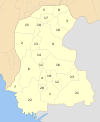 | |
| Hyderabad | ||
| Karachi | ||
| Larkana | ||
| Mirpur Khas |
| |
| Sukkur | ||
| Shaheed Benazir Abad |
| |
| show Authority control |
|---|

- Dadu District
- Districts of Sindh