Dagenham
| Dagenham | |
|---|---|
 The southern Dagenham skyline includes structures of the Ford plant and wind turbines. | |
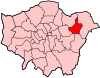
 Dagenham Location within Greater London | |
| Population | 106,247 (2011)[1] |
| OS grid reference | TQ485845 |
| • Charing Cross | 11.5 mi (18.5 km) W |
| London borough |
|
| Ceremonial county | Greater London |
| Region | |
| Country | England |
| Sovereign state | United Kingdom |
| Post town | DAGENHAM |
| Postcode district | RM8-RM10 |
| Dialling code | 020 |
| Police | Metropolitan |
| Fire | London |
| Ambulance | London |
| UK Parliament | |
| London Assembly | |

Dagenham (/ˈdæɡənəm/) is a town in East London, England, within the London Borough of Barking and Dagenham. It is adjacent to Barking to the west, Romford and Hornchurch to the north-east, and Rainham to the south-east, and Dagenham Dock, on the River Thames, is to the south. Dagenham is centred 11.5 miles (18.5 km) east of Charing Cross.
Formerly a rural area in the Becontree hundred within the historic county of Essex, Dagenham remained mostly undeveloped until 1921, when the London County Council began construction of the large Becontree estate. Dagenham Urban District was created in 1926, and became a municipal borough in 1938. In 1965, most of the area covered by the municipal borough became part of what is now the London Borough of Barking & Dagenham, a local government district of Greater London.
Dagenham is a predominantly residential area, also known for its now-declining industrial activity, including the Ford Dagenham plant. The southern part of Dagenham, known locally for planning purposes as Dagenham Riverside, forms part of the London Riverside section of the Thames Gateway redevelopment area.[2] At the 2011 Census, the total population of Dagenham, including the Becontree estate, was 106,247.[3]
History[]
| 1881 | 3,411 |
|---|---|
| 1891 | 4,324 |
| 1901 | 6,091 |
| 1911 | 7,930 |
| 1921 | 9,127 |
| 1931 | 89,362 |
| 1941 | # |
| 1951 | 114,568 |
| 1961 | 108,368 |
| # no census was held due to war | |
| source: UK census | |
Toponymy[]
Dagenham first appeared in a document (as Dæccanhaam) in a charter of Barking Abbey dating from 666 AD (though alternative 7th century dates have been suggested for the charter). The name almost certainly originated with a small farmstead, the "ham" or farm of a man called Daecca, as Dæccan hamm in Old English means home of a man called Dæcca.[4] The charter was made to reflect a transfer of land from Aethelred, kinsman of King Saebbi of Essex, to Barking Abbey.[5]
Manor of Barking[]
Dagenham has been historically defined by its Ancient Parish boundaries, which were subsequently re-used by the Municipal Borough of Dagenham up until 1965. The parish of Dagenham was formed in the medieval period to serve - along with parish of Barking (which included Great Ilford until the 19th century)[6] - the people of the huge manor of Barking, which was owned by the Nunnery of Barking Abbey. This reversed the usual situation where a parish would serve one or more manors. As with other manors, the area held by the declined over time, but the parish boundaries based on its former extent remained constant. Barking Abbey was dissolved in 1539.
Pre-urban landscape[]
Like most Essex Thames-side parishes, Dagenham was laid out on a N-S axis to give it a share of the marshes by the river, the agricultural land in the centre and the woods and commons on the poorer soils on the high ground in the north. Dagenham included a significant part of the now mostly lost Hainault Forest.
Dagenham Breach[]
South of Dagenham was a low-lying area including the Dagenham levels and Dagenham Marsh, these having been subject to periodic flooding from the Thames, and flood banks were built to protect the farmland, culminating in defences and a flood gate on the Beam River being built in the 17th century by Dutch engineers.[7] In 1707 an exceptionally high tide swept away fourteen feet of embankment and flooded over 1,000 acres of land, the description given by Daniel Defoe when he visited eight years later giving the area inundated as being 5000 acres is today considered an exaggeration.[7] The "Dagenham Breach" widened over time to a width of 400 feet, allowing the Thames to strip the top layer of marsh clay from the flood plain and deposited it as a mud bank in the Thames where it became a danger to shipping. Despite various remedies, the breach was not securely filled and a further flood occurred in 1718 after which, under an act of parliament, over £40,000 of public money was spent on successfully closing the breach[7] roughly at the location of Dagenham Dock. The closure of the gap left behind a large lake, also known as "Dagenham Breach" which became a popular spot for anglers. The lake is still there but much of it has silted up or been filled in and is now surrounded by industry,[8] but parts can still be identified as the lakes to the north of Ford's plant and also where Breach Lane follows the now lost western outline of the lake.
Whitebait Dinners[]
Dagenham was formerly home to the famous annual whitebait feast. The custom appears to have been started by the King's Commissioner of Works to celebrate the closure of the breach in the seawall around 1714–20, and was held every subsequent spring, on or around Trinity Sunday.
Many years later, Sir Robert Preston MP, invited his friend George Rose the Secretary of the Treasury and others to celebrate the feast, and on another occasion Rose invited the Prime Minister, William Pitt. Thereafter it became an obligatory ritual of government for the entire cabinet to come to Dagenham and celebrate the security of the Thames and over time this simple but hearty meal based on Whitebait and local Essex Ale grew more lavish, including turtle, grouse, champagne and a range of other luxury food and drink. Eventually the cabinet tired of the long trip to Dagenham and moved the event to Greenwich.[9]
Economic development[]
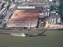
In 1931 the Ford Motor Company relocated from Trafford Park in Manchester, to a plant in Dagenham, which was already the location of supplier Briggs Motorway Bodies. A 500-acre (200 ha) riverside site was developed to become Europe's largest car plant, a vast vertically integrated site with its own blast furnaces and power station, importing iron ore and exporting finished vehicles. By the 1950s Ford had taken over Briggs at Dagenham and its other sites at Doncaster, Southampton, Croydon and Romford. At its peak the Dagenham plant had 4,000,000 square feet (370,000 m2) of floor space and employed over 40,000 people, although this number gradually fell during the final three decades of the 20th century as production methods advanced and Ford invested in other European factories as well.[10]
On 20 February 2002, full production was discontinued due to overcapacity in Europe and the relative difficulty of upgrading the 60-year-old site compared with other European sites such as Almussafes (Valencia, Spain) and Cologne. Other factors leading to the closure of the Auto-assembly line were the need of the site for the new Diesel Centre of Excellence, which produces half of Ford's Diesel Engines worldwide, and the UK employment laws when compared to Spanish, German and Belgian laws. In 2005 Cummins went into a joint venture and offered $15 million (US) to reinstate the factory. Ford and Cummins offered a good redundancy package, billed as one of the best in UK manufacturing. It is the location of the Dagenham wind turbines.[11] Some 4,000 people now work at the Ford plant.[12] The movie Made in Dagenham (2010) is a dramatisation of the 1968 Ford sewing machinists strike at the plant, when female workers walked out in protest against sexual discrimination and unequal pay.
Sterling, who manufactured British Army weapons and Jaguar car parts, were also based in Dagenham until they went bankrupt in 1988. Other industrial names once known worldwide were Ever Ready, whose batteries could be found in shops throughout the Commonwealth, Bergers Paint and the chemical firm of May & Baker who in 1935 revolutionized the production of antibiotics with their synthetic sulfa-drug known as M&B 693. The May & Baker plant, owned and run by Sanofi-Aventis, occupied a 108-acre site in Rainham Road South, near Dagenham East Underground station. It was abandoned in 2013 when the company closed it. The council will redevelop it with a new shopping centre: stores announced so far are a Sainsbury's supermarket and a pub restaurant. More stores will be announced in the future.
Local government[]
Dagenham was an ancient, and later civil, parish in the Becontree hundred of Essex.[13] The Metropolitan Police District was extended in 1840 to include Dagenham. The parish formed part of the Romford Rural District from 1894.[14][15] Dagenham Parish Council offices were located on Bull Street.
The expansion of the Greater London conurbation into the area caused the review of local government structures, and it was suggested in 1920 that the Dagenham parish should be abolished and its area divided between Ilford Urban District and Barking Town Urban District.[16] Separately, the London County Council proposed that its area of responsibility should be expanded beyond the County of London to cover the area.[17] Instead, in 1926 the Dagenham parish was removed from the Romford Rural District and designated as an urban district.[14] In 1938, in further recognition of its development, Dagenham became a municipal borough.[18] In 1965 the Municipal Borough of Dagenham was abolished and its former area became part of the London Borough of Barking,[19] which was renamed Barking and Dagenham in 1980.[20]
Market gardens to suburban estate[]

In 1205 Dagenham was large enough to have a chaplain, and the Parish Church of St Peter and St Paul was probably built at around that time.[21] In 1854, the London, Tilbury and Southend Railway was built through the south of Dagenham, near the River Thames. In 1885 a new direct route from Barking to Pitsea, via Upminster, was built with Dagenham station opened just north of the village. Dagenham Dock station opened on the original southern route in 1908. Dagenham was still an undeveloped village, when building of the vast Becontree estate by the London County Council began in the early 1920s.[22] The building of the enormous council estate, which also spread into the neighbouring parishes of Ilford and Barking,[16] caused a rapid increase in population.[23] In 1932 the electrified District line of the London Underground was extended to Upminster through Dagenham with stations opened as Dagenham and Heathway and today called Dagenham East and Dagenham Heathway.[24] Dagenham East was the location of the Dagenham East rail crash in 1958.[25] Services on the London Tilbury & Southend line at Dagenham East were withdrawn in 1962.
Governance[]
The wards of Eastbrook, Heath, River, Village and Whalebone are in the Dagenham and Rainham Parliamentary Constituency. The wards of Alibon, Mayesbrook, Parsloes, Thames and Valence are in the Barking Parliamentary Constituency. Each ward elects three councillors to Barking and Dagenham London Borough Council. The whole area is within the City and East London Assembly Constituency.
Geography[]

Dagenham is located approximately 11.5 miles (18.5 km) east of Charing Cross in Central London. The Becontree estate is largely in the pre-1965 borough of Dagenham, which also included Becontree Heath, part of Rush Green, Old Dagenham village, and the southern section around Dagenham Dock and adjacent to the River Thames. This southern section, which includes Ford Dagenham, is part of the London Riverside section of the Thames Gateway redevelopment zone. The Dagenham post town includes the whole of the Becontree estate, including those sections that were in the former (pre 1965) boroughs of Barking and Ilford. Parts of the former borough of Dagenham - part of Chadwell Heath, part of Collier Row and part of Rush Green - are in the Romford Post town.
(Dagenham is the name of a post town, and of a pre-1965 borough (and parish before that) with very different boundaries to the post town. Perhaps because of the name 'London Borough of Barking & Dagenham', adopted on 1 January 1980 to replace 'London Borough of Barking', there is an apparent popular - but incorrect - assumption that everywhere in that borough is either in Barking or in Dagenham. From 1965 it was true to say that everywhere in the then new London Borough was in one of the two former boroughs, but in the mid 1990s substantial areas of the London Borough of Redbridge were transferred to the borough, such that the entire Becontree and Padnall Estates were in LB Barking and Dagenham. Furthermore, parts of three post towns - Barking, Dagenham and Romford - cover the borough. The parliamentary constituency of Dagenham, formed in 1945, ceased to exist from the 2010 General Election, the six easternmost wards of LB Barking & Dagenham having become part of the Dagenham & Rainham Constituency, with three wards in LB Havering, leaving most LB Barking & Dagenham wards in the enlarged Barking constituency.)
Demography[]
Dagenham is a working class area. During the 2000s there was a large influx of migrants, in particular Africans.[26] The current population of the former (pre 1965) Borough of Dagenham could be approximated from the population of the current wards which together most closely match the area, but the former boundary between the borough and neighbouring Barking, with which it merged in 1965, no longer corresponds to any ward boundaries.
At the time of the 2011 census, the Alibon ward (north of Heathway station) was 61% White British and 15% Black African.[27] Goresbrook ward (southwest from Heathway) was 57% White British and 17% Black African.[28] River ward (south of Heathway) was 51% White British and 19% Black African.[29] Village ward (east from Heathway) was 58% White British and 19% Black African.[30] Eastbrook ward (around Eastbrookend Country) was 69% White British and 11% Black African.[31] Heath ward (north of Heathway) was 60% White British and 17% Black African.[32]
Transport[]
Dagenham is connected to the London Underground services from three stations, Becontree (in the pre-1965 borough of Barking), Dagenham East and Dagenham Heathway, all on the District line. c2c, part of National Rail operated by Trenitalia since February 2017, runs a train service through Dagenham Dock station.[33] TfL Rail services also operate from nearby Chadwell Heath station.
A proposed, and as yet unfunded Docklands Light Railway extension from Gallions Reach to Dagenham Dock. It was anticipated that the project could be completed and open for use by 2017.[34] However the public inquiry has been postponed due to concerns about funding.
Dagenham Heathway is served by the following Transport for London contracted routes: London Buses routes 145,173,174,175,287 and 364.[35] Routes 5, 103, 128, 150, 173, 174, 175, 499, and N15 and East London Transit service EL2 operate from Becontree Heath or the nearby Dagenham Civic Centre. Route 128 and EL1 runs a 24-hour service, while the N15 runs through the night.[36]
Culture[]
Valence House, in Becontree Avenue, is the only surviving of the five manor houses of Dagenham.[37] Dating back to the 13th century, it is sited in parkland and there is a moat around part of it. Valence House is the London Borough of Barking & Dagenham's local history museum, displaying artifacts and archives that tell the story of the lives of the people of Barking and Dagenham. The collection also includes portraits, family papers and other mementos of the Fanshawe family, who occupied Parsloes Manor, since demolished, from the sixteenth century.[38] The Fanshawe collection is "one of the best collections of gentry portraits in the country and is of international importance", according to Valence House.[39] Among members of the Fanshawe family was the diplomat Sir Richard Fanshawe, 1st Baronet, whose portrait is at Valence House. Nine successive members of the Fanshawe family served as Remembrancer to the Crown, following Henry Fanshawe's appointment to the position by Queen Elizabeth I in 1566. The appointment made possible the family's rise to prominence.
In the post town of Romford and the pre-1965 borough of Dagenham, on the corner of Whalebone Lane and the Eastern Avenue, diagonally opposite the Moby-Dick public house, is the site of Marks Manor House, a large 15th-century moated building demolished in the early 19th century. During World War II the adjoining fields were used by the Royal Artillery for an anti-aircraft battery; later a prisoner-of-war camp for Germans was erected there. Further south down Whalebone Lane on the corner of the High Road is the Tollgate pub. This stands on the site of the milestone which marked the ten mile (16 km) limit from the City of London and the turnpike toll-gate.
The Roundhouse public house on the junction of Porters Avenue and Lodge Avenue (in the pre-1965 borough of Barking) became eastern Greater London's premier rock-music venue between 1969 and 1975, incorporating the Village Blues Club. Notable performers at the pub included Jethro Tull, Supertramp, Queen, Pink Floyd, Eric Clapton, Status Quo, and Led Zeppelin (on 5 April 1969). The Eastbrook is a Grade II* listed pub.[40]
Media[]
The Barking & Dagenham Post is printed weekly and also published online.
Sport[]
Dagenham & Redbridge F.C., based at Victoria Road were relegated to the National League in the 2015/16 season from the Football League Two, after being relegated from the Football League One which they had reached having been promoted as playoff-winners of League two after beating Rotherham United F.C. 3–2, in the 2010/11 season. They were also the Nationwide Conference champions of the 2006/07 season.
Motorcycle speedway was staged at the greyhound stadium in Ripple Road in the mid to late 1930s. The club run events focussed on training but a team called the Dagenham Daggers did take part in local competitions. It is possible that the venture was operational as early as 1931 a meeting at Caxton (Cambridgeshire) was advertised as Caxton Speedway v Dagenham Speedway.
Dagenham's leading cricket club are based at the May & Baker Sports Club in Rainham Road South, in 2011 the club won the Essex County Cricket League for the first time in its history.
Dagenham has a King George's Field in memorial to King George V. The park, which has been in existence for over a century [give date], was renamed in 1953 by Queen Elizabeth II. Dagenham also has many other parks such as Valence - and Parsloes (which lies partly in the pre-1965 borough of Barking). Dagenham Crusaders Drum and Bugle Corps, founded by John Johnson, was the first British Drum Corps and performed in the United States for the first time in 1983. In 2010 they reformed to perform for DCUK's 30th anniversary, fielding a competitive corps for the first time in 22 years.[41]
The town is also home to the Dagenham Girl Pipers, a bagpipe marching band founded in 1930 by the Revd Joseph Waddington Graves.
Notable people[]
Please see 'Geography' above for various definitions of 'Dagenham'.
- Revd Abraham Blackborne, one of the longest-serving vicars of Dagenham.[42]
- England international footballer and World Cup-winning manager Alf Ramsey was born in Dagenham in 1920.[43]
- St Peter and St Paul's Church in Dagenham was once the Parish Church of the former archbishop of Canterbury, George Carey.
- Musician and comedian Dudley Moore was brought up in Dagenham,[44] which was the home of Peter Cook and Dudley Moore's famous comic alter-egos Pete and Dud.[45]
- Sandie Shaw, 1960s pop singer, who had a string of hit singles in the decade and won the Eurovision Song Contest in 1967 with Puppet on a String
- Rap artist Devlin is from Dagenham.
- Actor, comedian, screenwriter, producer and author Nick Frost is from Dagenham.
- Depeche Mode member Martin Gore was born in Dagenham.
- Cage Warriors matchmaker Ian Dean is from Dagenham.
- Australian singer John Farnham was born in Dagenham before migrating.[46]
- Former darts player Wayne Mardle was born in Dagenham before living in Romford.
- British singer, TV presenter, and personality Stacey Solomon is from Dagenham.
References[]
- Notes
- ^ The 10 wards in the London Borough of Barking and Dagenham that constitued Dagenham Parliamentary constituency from 1983-2010 were: Alibon, Becontree, Eastbrook, Goresbrook, Heath, Mayesbrook, Parsloes, River, Valence, and Village. In 2010 part of constituency was ceded to Barking constituency and the rest became part of Dagenham & Rainham Constituency."Archived copy". Archived from the original on 22 February 2014. Retrieved 9 June 2014.CS1 maint: archived copy as title (link)
- ^ Gander, Kashmira (6 August 2015). "Worst places to live in the UK: Barking and Dagenham come first in top 10 list dominated by nine London boroughs". The Independent. Retrieved 13 May 2019.
- ^ "2011 Census Ward Population Estimates". Greater London Authority. Archived from the original on 22 February 2014. Retrieved 9 June 2014.
- ^ Mills 2001, p. 64
- ^ On the context of the charter https://www.british-history.ac.uk/vch/essex/vol5/pp190-214
- ^ on the history of the Manor of Barking https://www.british-history.ac.uk/vch/essex/vol5/pp190-214
- ^ Jump up to: a b c Neale, Kenneth (1970). Discovering Essex in London. Essex Countryside. pp. 111–113. ISBN 0900519142.
- ^ http://www.barkinghistory.co.uk/dagenham-breach.html[bare URL]
- ^ Simon Schama – Landscape and Memory p352-354
- ^ Ford UK – History of Ford in Britain Archived 17 December 2007 at the Wayback Machine
- ^ Greater London Authority – Wind Turbines, Ford Estate, Dagenham planning application Archived 4 June 2011 at the Wayback Machine. 4 June 2003.
- ^ Milestones: Ford Dagenham Estate Celebrates 80 Years of Manufacturing. TheDetroitBureau.com (13 May 2009). Retrieved on 8 August 2012.
- ^ British History Online – The Hundred of Becontree
- ^ Jump up to: a b Vision of Britain – Dagenham parish Archived 1 October 2007 at the Wayback Machine (historic map Archived 30 September 2007 at the Wayback Machine)
- ^ Vision of Britain – Romford RD Archived 30 September 2007 at the Wayback Machine (historic map Archived 30 September 2007 at the Wayback Machine)
- ^ Jump up to: a b British History Online – The borough of Barking. Date accessed: 5 May 2007.
- ^ Greater London: Case for Central Authority: Area and Powers. The Times. 14 December 1921.
- ^ Vision of Britain – Dagenham MB Archived 1 October 2007 at the Wayback Machine
- ^ Vision of Britain – Barking LB
- ^ Barking and Dagenham London Borough Council – The Mayor Archived 26 September 2007 at the Wayback Machine
- ^ "Old Dagenham Village". Heritage and History. Barking and Dagenham London Borough Council. Archived from the original on 4 January 2008.
- ^ Olechnowicz, A., Working-Class Housing in England Between the Wars: The Becontree Estate (1997)
- ^ Vision of Britain – Dagenham population
- ^ Rose, D., The London Underground: A diagrammatic history, (1999)
- ^ Railways Archive – Report on the collision at Dagenham East – 30.01.58
- ^ Asthana, Anushka (21 March 2010). "Dagenham's heyday: 'It was all just one big happy family then'". The Observer. pp. 18–19. Retrieved 23 March 2010.
- ^ Services, Good Stuff IT. "Alibon - UK Census Data 2011". UK Census Data.
- ^ Services, Good Stuff IT. "Goresbrook - UK Census Data 2011". UK Census Data.
- ^ Services, Good Stuff IT. "River - UK Census Data 2011". UK Census Data.
- ^ Services, Good Stuff IT. "Village - UK Census Data 2011". UK Census Data.
- ^ Services, Good Stuff IT. "Eastbrook - UK Census Data 2011". UK Census Data.
- ^ Services, Good Stuff IT. "Heath - UK Census Data 2011". UK Census Data.
- ^ c2c – Stations and route map Archived 28 February 2007 at the Wayback Machine
- ^ Transport for London - Docklands Light Railway - Dagenham Dock: Key Project Milestones Archived 15 June 2009 at the Wayback Machine
- ^ Transport for London – Buses from Dagenham Heathway -
- ^ 287, 62 and many other buses run through this area.Transport for London – Buses from Becontree Heath –
- ^ Valence House museum Archived 22 July 2012 at the Wayback Machine. lbbd.gov.uk
- ^ The Fanshawe Family, London Borough of Barking and Dagenham, barking-dagenham.gov.uk
- ^ Elizabeth Ogborne, The History of Essex: From the Earliest Period to the Present Time, Printed for the Proprietors by R.H. Kelham, London, 1814, p. 61.
- ^ Historic England. "Eastbrook public house (1393600)". National Heritage List for England. Retrieved 19 April 2014.
- ^ "Drumming up support for corps reunion". 21 January 2010. Retrieved 16 July 2020.
- ^ "Blackburne, Abraham (BLKN733A)". A Cambridge Alumni Database. University of Cambridge.
- ^ "Sir Alf Ramsey". The Daily Telegraph. London. 1 May 1999. Archived from the original on 17 May 2010. Retrieved 6 September 2016.
- ^ Parkinson, David (January 2011). "Moore, Dudley Stuart John (1935–2002)". Oxford Dictionary of National Biography. Online ed (Online ed.). Oxford: OUP.
- ^ Cook, Peter; Moore, Dudley (2003). Dud and Pete The Dagenham Dialogues. Methuen. ISBN 978-0-413-77347-0.
- ^ Apter, Jeff (30 October 2016). Playing to Win: The Definitive Biography of John Farnham. Nero. ISBN 9781863958806 – via Google Books.
- Bibliography
- Mills, A.D. (2001), Dictionary of London Place Names, Oxford, ISBN 0-19-280106-6
- Powell, W.R. (Edr.) (1966), Dagenham, A History of the County of Essex: Volume 5, Victoria County History, British History Online, retrieved 1 November 2009
- Terry Cooper Death by Dior: Françoise Dior, (Dynasty Press, 2013, ISBN 978-0-9568038-6-3)
Further reading[]
- Edward Walford (1883), "Dagenham", Greater London, London: Cassell & Co., OCLC 3009761
External links[]
![]() Media related to Dagenham at Wikimedia Commons
Media related to Dagenham at Wikimedia Commons
| show London Borough of Barking and Dagenham |
|---|
| show Authority control |
|---|
- Dagenham
- Areas of London
- Districts of the London Borough of Barking and Dagenham
- Vehicle manufacture in London