Dawes Point, New South Wales
| Dawes Point Sydney, New South Wales | |||||||||||||||
|---|---|---|---|---|---|---|---|---|---|---|---|---|---|---|---|
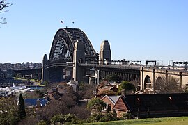 Sydney Harbour Bridge, viewed from Observatory Hill | |||||||||||||||
 Dawes Point | |||||||||||||||
 | |||||||||||||||
| Coordinates | 33°51′22″S 151°12′25″E / 33.856°S 151.207°ECoordinates: 33°51′22″S 151°12′25″E / 33.856°S 151.207°E | ||||||||||||||
| Population | 357 (2016 census)[1] | ||||||||||||||
| • Density | 3,600/km2 (9,000/sq mi) | ||||||||||||||
| Postcode(s) | 2000 | ||||||||||||||
| Area | 0.1 km2 (0.0 sq mi) | ||||||||||||||
| Location | 1 km (1 mi) north of Sydney CBD | ||||||||||||||
| LGA(s) | City of Sydney | ||||||||||||||
| Parish | St. Philip | ||||||||||||||
| State electorate(s) | Sydney | ||||||||||||||
| Federal Division(s) | Sydney | ||||||||||||||
| |||||||||||||||

Dawes Point is a suburb of the City of Sydney, in the state of New South Wales, Australia. Dawes Point is located on the north-western edge of the Sydney central business district, at the southern end of Sydney Harbour Bridge, adjacent to The Rocks. At times Dawes Point has been considered to be part of The Rocks, or known as West Rocks, part of Millers Point, or part of it known as Walsh Bay.
History[]
The suburb of Dawes Point is on unceded Gadigal Country. The point was originally known by the Aboriginal names of Tar-ra and Tullagalla. This was later changed by Governor Hunter at William Dawes' request to Point Maskelyne in honour of his patron Reverend Dr Nevil Maskelyne, British Astronomer Royal.[2] He sent out the first astronomical instruments which were established at the point in the country's first observatory, by Lieutenant William Dawes (1762-1836), astronomer with the First Fleet. The point was renamed in honour of Dawes.[3] Dawes Point is one of the places around Sydney Harbour that has been officially gazetted as a dual named site by the NSW Geographical Names Board. It was officially gazetted Dawes Point / Tar-Ra in 2002.[4]
It was also the site of the first guns mounted in Sydney by Dawes in 1788, contained Sydney's first cemetery and later Dawes Point Battery. Walsh Bay was the site of Sydney's port facilities. The wharves were converted to apartments, theatres, restaurants, cafes and a hotel.
By the 1840s, the people of Dawes Point and Millers Point were a maritime community in which rich and poor mixed more than elsewhere in Sydney. Wharf owners and traders lived and worked beside those who worked on the wharves and bond stores, as well as those who arrived and left on ships.[5] Only two of the merchant houses, built by and for the early wharf owners, survive. One is Walker's 50-foot wide villa built around 1825 and now part of Milton Terrace at 7-9 Lower Fort Street; the other is the home and offices of Edwards and Hunter, built in 1833 above their wharves which is where the Wharf Theatre now stands.[6]
Mostly prosperous in its early years, the area was less desirable by the 1890s. At the beginning of the 20th century, the government compulsorily acquired all private wharves, homes and commercial properties in the Rocks, Dawes Point and Millers Point. Modern and efficient wharves with dual level access were built, as well as new accommodation for workers, such as the Workers Flats of Lower Fort Street designed by Government Architect Vernon.[7]
In the 1960s and '70s, high-rise offices were proposed for the area, but Green Bans, supported by community and unions, helped thwart these plans.[citation needed]
Following the Green Bans, and its most prominent campaign, The Battle for The Rocks, urban planning included more community consultation. The Rocks Green Ban was lifted so the Sirius Building could be built to house those displaced by The Rocks redevelopment and to house members of the maritime community whose families had lived in The Rocks, Dawes Point and Millers Point since the earliest years of the Colony.[citation needed]
During 2014–18, the majority of the area's social housing was sold and its tenants left the Millers Point area. The NSW Government also sold the Sirius Building for redevelopment as private apartments.[8]
Heritage listings[]
Dawes Point has a number of heritage-listed sites, including:
- 37 Lower Fort Street: Dawesleigh[9]
- Bradfield Highway and North Shore railway: Sydney Harbour Bridge[10]
- 8-12 Trinity Avenue: Darling House c1833-1842[11]: 6
- 1-19 Lower Fort Street: Milton Terrace
- 21-23 Lower Fort Street, Millers Point: Nicholson's Cottages
- 25-33 Lower Fort Street: Linsley Terrace
- 35 Lower Fort Street: Major House
- 39-41 Lower Fort Street: John Verge Townhouses
- 43 Lower Fort Street: Bligh House (Clydebank)
- 47-53 Lower Fort Street: Palermo Terrace
- 57-61 Lower Fort Street: Flavelle Terrace
- 63-65 Lower Fort Street
- 69-73 Lower Fort Street
- 75-77 Lower Fort Street
- 79 Lower Fort Street
- 81 Lower Fort Street, The Hero of Waterloo Hotel[12]
Population[]
In the 2016 Census, there were 357 people in Dawes Point. 63.8% of people were born in Australia and 76.2% of people only spoke English at home. The most common response for religion was No Religion at 39.9%.
Median mortgage repayments were $5,200 a month or $62,400 a year, the highest median mortgage repayment in the greater Sydney area.[1][13]
Culture[]
The Sydney Theatre and The Wharf Theatre, which are part of the Sydney Theatre Company, are located in Dawes Point.
Gallery[]
The Sydney Theatre and The Wharf Theatre, which are part of the Sydney Theatre Company, are located in Dawes Point
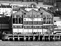
Pier One on Walsh Bay
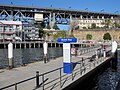
Walsh Bay ferry wharf

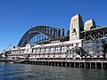
Southern approach of the Sydney Harbour Bridge with Dawes Point to the right.

Terraces, Pottinger Street (c. 2007)

Terraces, Pottinger Street (c. 2007)
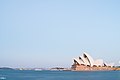
The Sydney Opera House seen from Dawes Point
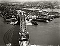
Aerial view of Dawes point in the 1930s


References[]
- ^ Jump up to: a b Australian Bureau of Statistics (27 June 2017). "Dawes Point (State Suburb)". 2016 Census QuickStats. Retrieved 2 July 2017.

- ^ Mander-Jones, Phyllis (1966). "Dawes, William (1762–1836)". Australian Dictionary of Biography. Retrieved 10 July 2021.
- ^ The Book of Sydney Suburbs, Compiled by Frances Pollon, Angus & Robertson Publishers, 1990, Published in Australia ISBN 0-207-14495-8, page 81
- ^ "Tar-Ra place name". NSW Geographical Names Board. Retrieved 10 July 2021.
- ^ "1840". MILLERS POINT.
- ^ "37 & 35 Lower Fort Street". MILLERS POINT.
- ^ "The Workers Flats of Millers Point". MILLERS POINT.
- ^ "Why Sirius Matters – Save Our Sirius". Retrieved 10 March 2019.
- ^ "Dawesleigh". New South Wales State Heritage Register. Office of Environment and Heritage. H00522. Retrieved 18 May 2018.
- ^ "Sydney Harbour Bridge, approaches and viaducts (road and rail)". New South Wales State Heritage Register. Office of Environment and Heritage. H00781. Retrieved 18 May 2018.
- ^ Casey and Lowe Associates (1994). Excavation Report, Darling House, Millers Point. NSW Department of Housing.
- ^ "History | The Hero of Waterloo - The Rocks, Sydney, Australia. Established 1843. Live music, award winning food, ghost tours and a heritage landmark classification it is a must when visiting The Rocks, the birthplace of the nation, to include a visit and soak up the atmosphere at this convict-built hotel". Retrieved 10 March 2019.
- ^ "Sydney's biggest mortgage bills: how your suburb compares".
External links[]
![]() Media related to Dawes Point, New South Wales at Wikimedia Commons
Media related to Dawes Point, New South Wales at Wikimedia Commons
- Fitzgerald, Shirley (2008). "Dawes Point". Dictionary of Sydney. Retrieved 26 September 2015. [CC-By-SA]
- Suburbs of Sydney
- Dawes Point, New South Wales
- Sydney New Year's Eve