Dayton, Kentucky
Dayton, Kentucky | |
|---|---|
City | |
 | |
| Motto(s): "A pluck and grit that others mimic"[1] | |
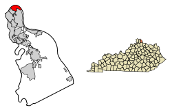 Location of Dayton in Campbell County, Kentucky. | |
| Coordinates: 39°6′42″N 84°28′13″W / 39.11167°N 84.47028°WCoordinates: 39°6′42″N 84°28′13″W / 39.11167°N 84.47028°W | |
| Country | United States |
| State | Kentucky |
| County | Campbell |
| Government | |
| • Type | Mayor-Council |
| • Mayor | Ben Baker[2] |
| Area | |
| • Total | 1.94 sq mi (5.03 km2) |
| • Land | 1.30 sq mi (3.37 km2) |
| • Water | 0.64 sq mi (1.66 km2) |
| Elevation | 515 ft (157 m) |
| Population (2010) | |
| • Total | 5,338 |
| • Estimate (2019)[3] | 5,609 |
| • Density | 4,311.30/sq mi (1,664.77/km2) |
| Time zone | UTC-5 (Eastern (EST)) |
| • Summer (DST) | UTC-4 (EDT) |
| ZIP codes | 41073-41074 |
| Area code(s) | 859 |
| FIPS code | 21-20350 |
| GNIS feature ID | 0490708 |
| Website | www |

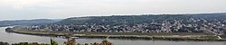
Dayton is a home rule-class city[5] along a bend of the Ohio River in Campbell County, Kentucky, in the United States. The population was 5,338 at the 2010 census.[6] It is less than 3 miles (5 km) from downtown Cincinnati, Ohio.
Geography[]
Dayton is located in the northernmost part of Campbell County at 39°6′42″N 84°28′13″W / 39.11167°N 84.47028°W (39.111781, −84.470401),[7] on the inside of a bend in the Ohio River. It is the most northernmost community in Kentucky as well. Dayton is bordered by Bellevue to the southwest and Fort Thomas to the southeast. To the north, across the Ohio River, is Cincinnati in Hamilton County, Ohio. The closest bridge across the Ohio is the Daniel Carter Beard Bridge on Interstate 471, connecting Newport with Cincinnati.
According to the United States Census Bureau, Dayton has a total area of 1.9 square miles (5.0 km2), of which 1.3 square miles (3.3 km2) is land and 0.66 square miles (1.7 km2), or 33.61%, is water.[6] Dayton is located within Kentucky's Outer Bluegrass region in the Upper South.
Climate[]
The climate in this area is characterized by hot, humid summers and generally mild to cool winters. According to the Köppen Climate Classification system, Dayton has a humid subtropical climate, abbreviated "Cfa" on climate maps.[8]
History[]
Dayton had a ferry crossing, established in this area by the early 19th century, at the foot of what is now Dayton Pike.
Two separate cities, Jamestown and Brooklyn, separately incorporated in 1848 and 1849 respectively, were merged and reincorporated in 1867 under the name Dayton[9] in honor of the Ohio town.[10]
Jamestown was incorporated March 1, 1848. According to the state charter, the founding fathers were James Berry, James McArthur and Henry Walker. Berry was a nephew of James Taylor, Jr., founder of Newport, Kentucky.
Dayton has a large sandbar just offshore. It had a popular beach for many years known as the "Manhattan Bathing Beach", until the US Army Corps of Engineers raised the level of the Ohio River. In 1779, the beach was involved in the Battle of Dayton, KY; the fight involved Simon Girty, Alexander McKee, Col, John Campbell, Col. David Rogers and Capt. Robert Benham. Laws were passed prohibiting nude swimming in the Ohio River during daylight hours and prohibiting dogs from running loose. Violators of the nude swimming law faced a penalty of $1 for the first offense and as much as $5 for subsequent offenses. People also had the right to shoot dogs that were running loose in the city, and bill the owners for carcass removal.[11]
Floods in 1884, 1913, and 1937 – the latter affecting 80 percent of the city and prompting residents to take shelter in the garages of the former Wadsworth Watch Case Co. – caused many of the companies in the once-booming town to move elsewhere. By the 1950s, many residents, weary of constant flooding, moved out of the town as well. A floodwall was finally completed in late 1981.[12]
Today[when?], Dayton is working on downtown revitalization and a historical survey of the city; it is the first step toward creating a historic district in the city.
Demographics[]
| Historical population | |||
|---|---|---|---|
| Census | Pop. | %± | |
| 1870 | 1,749 | — | |
| 1880 | 3,210 | 83.5% | |
| 1890 | 4,264 | 32.8% | |
| 1900 | 6,104 | 43.2% | |
| 1910 | 6,979 | 14.3% | |
| 1920 | 7,646 | 9.6% | |
| 1930 | 9,071 | 18.6% | |
| 1940 | 8,379 | −7.6% | |
| 1950 | 8,977 | 7.1% | |
| 1960 | 9,050 | 0.8% | |
| 1970 | 8,751 | −3.3% | |
| 1980 | 6,979 | −20.2% | |
| 1990 | 6,576 | −5.8% | |
| 2000 | 5,966 | −9.3% | |
| 2010 | 5,338 | −10.5% | |
| 2019 (est.) | 5,609 | [3] | 5.1% |
| U.S. Decennial Census[13] | |||
As of the census[14] of 2000, there were 5,966 people, 2,200 households, and 1,518 families residing in the city. The population density was 4,494.7 people per square mile (1,731.9/km2). There were 2,401 housing units at an average density of 1,808.9 per square mile (697.0/km2). The racial makeup of the city was 98.32% White, 0.45% African American, 0.18% Native American, 0.17% Asian, 0.02% Pacific Islander, 0.08% from other races, and 0.77% from two or more races. Hispanic or Latino of any race were 0.59% of the population.
There were 2,200 households, out of which 35.2% had children under the age of 18 living with them, 45.3% were married couples living together, 18.0% had a female householder with no husband present, and 31.0% were non-families. 25.5% of all households were made up of individuals, and 10.6% had someone living alone who was 65 years of age or older. The average household size was 2.69 and the average family size was 3.24.
In the city the population was spread out, with 28.2% under the age of 18, 11.9% from 18 to 24, 29.8% from 25 to 44, 19.5% from 45 to 64, and 10.6% who were 65 years of age or older. The median age was 32 years. For every 100 females, there were 96.1 males. For every 100 females age 18 and over, there were 92.0 males.
The median income for a household in the city was $32,008, and the median income for a family was $38,339. Males had a median income of $28,592 versus $21,048 for females. The per capita income for the city was $15,373. About 15.2% of families and 16.3% of the population were below the poverty line, including 24.4% of those under age 18 and 4.7% of those age 65 or over.
Notable people[]
- Robert Agnew, actor who worked mostly in the silent film era, making 65 films in both the silent and sound eras
- Edward H. Ahrens, recipient of Navy Cross, died at Guadalcanal
- Todd Benzinger, former Major League Baseball player
- Lonnie Burr, actor, dancer/choreographer, singer, director and author
- Earl Murray, football player
- Will Radcliff, businessman who created the Slush Puppie
- Jesse Tannehill, former MLB player
- Lee Tannehill, former MLB player
- John Wooden, Hall of Fame basketball coach, coached at Dayton High during 1932–33 and 1933–34 school years
See also[]
- List of cities and towns along the Ohio River
References[]
- ^ "Homepage". City of Dayton, KY. Retrieved 26 August 2014.
- ^ "Mayor and Council Members". City of Dayton, KY. Retrieved 18 February 2019.
- ^ Jump up to: a b "Population and Housing Unit Estimates". United States Census Bureau. May 24, 2020. Retrieved May 27, 2020.
- ^ "2019 U.S. Gazetteer Files". United States Census Bureau. Retrieved July 24, 2020.
- ^ "Summary and Reference Guide to House Bill 331 City Classification Reform" (PDF). Kentucky League of Cities. Retrieved December 30, 2014.
- ^ Jump up to: a b "Geographic Identifiers: 2010 Demographic Profile Data (G001): Dayton city, Kentucky". U.S. Census Bureau, American Factfinder. Retrieved August 5, 2014.
- ^ "US Gazetteer files: 2010, 2000, and 1990". United States Census Bureau. 2011-02-12. Retrieved 2011-04-23.
- ^ Climate Summary for Dayton, Kentucky
- ^ Clarke, S. J. (1912). Cincinnati, the Queen City, 1788–1912, Volume 2. The S. J. Clarke Publishing Company. p. 533. Retrieved 2013-05-20.
- ^ Preserve America. "Dayton, Ky".
- ^ City of Dayton. "Official site".
- ^ Local – The Enquirer – June 30, 1997
- ^ "Census of Population and Housing". Census.gov. Retrieved June 4, 2015.
- ^ "U.S. Census website". United States Census Bureau. Retrieved 2008-01-31.
External links[]
- City website
- Historical Images and Texts of Dayton, Kentucky
- Bank of Dayton Building
- St. John's P.E. Church
- St. Bernard Church (Dayton, Ky.)
- Sixth Avenue
| show Municipalities and communities of Campbell County, Kentucky, United States |
|---|

| show Authority control |
|---|
- Cities in Campbell County, Kentucky
- Kentucky populated places on the Ohio River
- Populated places established in 1867
- Cities in Kentucky