Derai Upazila
This article needs additional citations for verification. (July 2015) |
Derai
দিরাই | |
|---|---|
Upazila | |
 | |
 | |
| Country | |
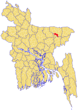
| Division | Sylhet Division |
| District | Sunamganj District |
| Thana | 1942 |
| Upazila | 1982 |
| Government | |
| • MP (Sunamganj-2) | Joya Sengupta |
| • Upazila Chairman | Muhammad Manzur Alam Chowdhury |
| Area | |
| • Total | 420.93 km2 (162.52 sq mi) |
| Time zone | UTC+6 (BST) |
| Postal code | 3040-41 |
| Website | www |
Derai (Bengali: দিরাই) is an upazila (sub-district) of the Sunamganj District in northeastern Bangladesh, part of the Sylhet Division.[1]
Geography[]
Derai is located at 24°47′00″N 91°21′00″E / 24.7833°N 91.3500°E. It is bounded by Dakshin Sunamganj and Jamalganj on the north, Sullah, Baniachong and Nabiganj on the south, Jagannathpur on the east, Sullah, Khaliajuri and Jamalganj on the west. Sitting on the banks of the Kalni river, Derai is a part of the Bhati lowlands. Other rivers in Derai are the Surma, Dahuka and Kushiyara. Derai is also home to beels such as Tatua, Ainal, Bhogdoba, Haria and Jalaldi.
 WikiMiniAtlas
History[]
Derai was previously known as Babaganj Bazar. It was home to two influential Hindu residents; Jitarāma and Dvidarāma, who renamed the area to Derai Bazar. On 10 December 1892, the Assam Gazette notification #5954 recognised the name of the area as Derai. In 1938, the Nankar Rebellion started in Derai and surrounding areas. Derai was made a thana in 1942.
During the Bangladesh Liberation War of 1971, a brawl took place in Derai between the Pakistan Army and Bengali freedom fighting forces. Among the freedom fighters here, Commander Ataur Rahman and Abdul Khaliq were wounded with Azimullah, Kuti Miah and Gopendra Das being killed.
Derai was heavily affected by the 1974 floods and that of 1988. The Jamiah Hafizia Hussainiya Madrasa was founded in 1978. In 1982, Derai thana was made an upazila. The 2004 Indian Ocean earthquake and tsunami was also very damaging to Derai.[1]
Demographics[]
As of the 2001 Bangladesh census, Derai has a population of 202791; male 105252, female 97539; Muslim 144136, Hindu 58576, Buddhist 33 and others 46. Males constitute 51.38% of the population, and females 48.62%.
Education[]
Derai has an average literacy rate of 25.3% (7+ years), and the national average of 32.4% literate.[2]
There are two orphanages in Derai; one in Sadar and one in Ranarachar.
Economy and tourism[]

Derai has a rich culture due to its folk tradition and being the birthplace of prominent Bauls such as Shah Abdul Karim.[3] There are 80 clubs, 2 libraries, 2 cinema halls, 1 theatre stage, 4 jatra groups, 2 women organisations, and 5 cultural organisations in Derai.
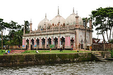
Some of the archeological and historical sites of Derai include the mazar (mausoleum)s of Pir Aqil Shah-e-Hatiya, Baba Shah-e-Gachiya, Baba Shah-e-Nagadipur Chhayhara, Moshahid Shah Umednagari, Rahim Shah, Maram Shah Umednagari, Mustafa Shah Zakinagari, Dulal Shah Kejauri, Rangin Shah Mirzapuri and Lengta Shah, as well as the zamindar palaces in Sarmangal and Bhatipara, the coconut gardens of Rajanagar and the garden-house of Rajaniganj Bazar. Out of the 253 mosques in the upazila, the mosques of Bhatipara, Nachni and Husaynpur are notable.
Administration[]
Derai thana was formed in 1942 and it was turned into an upazila in 1982.
Derai Upazila is divided into Derai Municipality and nine union parishads: Bhatipara, Charnarchar, Derai Sarmangal, Jagdal, Karimpur, Kulanj, Rafinagar, Rajanagar, and Taral. The union parishads are subdivided into 137 mauzas and 232 villages.[4]
Derai Municipality is subdivided into 9 wards and 29 mahallas.[4]
Upazila Chairmen[]
| Number | Name | Notes |
|---|---|---|
| 01 | Nasir Uddin Chowdhury | |
| 02 | Abdul Quddus | |
| 03 | Muhammad Hafizur Rahman Taluqdar | 20/3/2014-9/5/2019 |
| 04 | Muhammad Manzur Alam Chowdhury | Present |
Notable people[]
- Gulzar Ahmed Chowdhury, former Member of Parliament
- Joya Sengupta, medical doctor and politician
- Kakon Bibi, secret agent
- Mifta Uddin Chowdhury Rumi, politician and justice
- Nasir Uddin Chowdhury, politician
- Shah Abdul Karim, folk minstrel
- Suranjit Sengupta, Bangladesh's first Minister of Railways
See also[]
- Upazilas of Bangladesh
- Districts of Bangladesh
- Divisions of Bangladesh
References[]
| Wikimedia Commons has media related to Derai Upazila. |
- ^ Jump up to: a b Chanda, Jiban Kumar (2012). "Derai Upazila". In Islam, Sirajul; Miah, Sajahan; Khanam, Mahfuza; Ahmed, Sabbir (eds.). Banglapedia: the National Encyclopedia of Bangladesh (Online ed.). Dhaka, Bangladesh: Banglapedia Trust, Asiatic Society of Bangladesh. ISBN 984-32-0576-6. OCLC 52727562. Retrieved 9 September 2021.
- ^ "Population Census Wing, BBS". Archived from the original on 2005-03-27. Retrieved November 10, 2006.
- ^ Mintu, Deshwara (15 February 2016). "Birth centenary of Shah Abdul Karim". The Daily Star.
- ^ Jump up to: a b "District Statistics 2011: Sunamganj" (PDF). Bangladesh Bureau of Statistics. Archived from the original (PDF) on 13 November 2014. Retrieved 14 July 2014.
| show |
|---|

| show Authority control |
|---|
This Sylhet Division location article is a stub. You can help Wikipedia by . |
- Derai Upazila
- Upazilas of Sunamganj District
- Sylhet Division geography stubs