Dolní Měcholupy
Dolní Měcholupy
Dolní Měcholupy | |
|---|---|
Municipal District of Prague Cadastral Area of Prague | |
 Dolní Měcholupy town hall | |
 Flag  Coat of arms | |
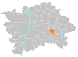 Location of Dolní Měcholupy in Prague | |
| Coordinates: 50°3′32″N 14°33′31″E / 50.05889°N 14.55861°ECoordinates: 50°3′32″N 14°33′31″E / 50.05889°N 14.55861°E | |
| Country | Czech Republic |
| Region | Prague |
| District | Prague 15 |
| Government | |
| • Mayor | Karel Hagel |
| Area | |
| • Total | 4.66 km2 (1.80 sq mi) |
| Population (2008) | |
| • Total | 1,788 |
| • Density | 380/km2 (990/sq mi) |
| Time zone | UTC+1 (CET) |
| • Summer (DST) | UTC+2 (CEST) |
| Postal code | 109 00 |
| Website | http://www.dolnimecholupy.cz |

Dolní Měcholupy is a municipal district (městská část) and cadastral area (katastrální území) in Prague. It is located in the eastern part of the city. As of 2008, there were 1,788 inhabitants living in Dolní Měcholupy.
The first written record of Dolní Měcholupy is from the 14th century. The village became part of Prague in 1968.
External links[]
| Wikimedia Commons has media related to Dolní Měcholupy. |
| Authority control: National libraries |
|---|
This Prague location article is a stub. You can help Wikipedia by . |
Categories:
- Districts of Prague
- Prague geography stubs