Zadní Kopanina
Zadní Kopanina | |
|---|---|
Cadastral district of Prague | |
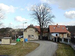 Old inn of K Zadní Kopanině. | |
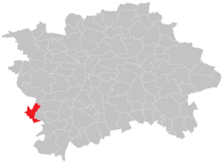 Location of Zadní Kopanina within the City of Prague. | |
| Coordinates: 50°0′23.5″N 14°18′47.7″E / 50.006528°N 14.313250°ECoordinates: 50°0′23.5″N 14°18′47.7″E / 50.006528°N 14.313250°E | |
| Country | Czech Republic |
| City | Prague |
| District | Prague 13 |
| Incorporated into Prague | 1974 |
| Area | |
| • Total | 3.5 km2 (1.4 sq mi) |
| Population (31 December 2016)[1] | |
| • Total | 74 |
| • Density | 21/km2 (55/sq mi) |
| Time zone | UTC+1 (CET) |
| • Summer (DST) | UTC+2 (CEST) |

Zadní Kopanina (German: Hinter Kopanin) is a cadastral district of Prague, Czech Republic. It is the less populated cadastral area of Prague, with 74 inhabitants as of 13 December 2016.[1]
References[]
- ^ Jump up to: a b c "Obyvatelstvo a rozloha katastrálních území Prahy 2001–2015". Český statistický úřad. Retrieved 2016-06-08.
| Authority control: National libraries |
|---|
This Prague location article is a stub. You can help Wikipedia by . |
Categories:
- Districts of Prague
- Prague geography stubs