Dongducheon
Dongducheon
동두천시 | |
|---|---|
Municipal City | |
| Korean transcription(s) | |
| • Hangul | 동두천시 |
| • Hanja | 東豆川市 |
| • Revised Romanization | Dongducheon-si |
| • McCune-Reischauer | Tongduch'ŏn-si |
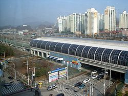 Jihaeng Station in Dongducheon | |
 Flag Emblem of Dongducheon | |
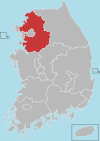
 Location in South Korea | |
| Country | |
| Region | Sudogwon |
| Administrative divisions | 8 dong |
| Area | |
| • Total | 95.66 km2 (36.93 sq mi) |
| Population (2006) | |
| • Total | 82,623 |
| • Density | 864/km2 (2,240/sq mi) |
| • Dialect | Seoul |
| Website | Dongducheon Office |
Dongducheon (Korean pronunciation: [ˈto̞ŋ.du.tsʰʌ̹n]) is a city in Gyeonggi Province, South Korea.
The city, to the north of Seoul, is strategically important for the defense of the Korean capital. The main camps of the United States Second Infantry Division are in the city, and the division command is at Uijeongbu.
History[]
Under Goguryeo, the dynasty's territory extended southward into Korean peninsula, and Dongducheon became part of the kingdom in the form of naeulmae hyun (a certain form of ancient village land holding). Later Dongducheon became Sacheon village of Unified Silla in the North-South States Period. It was part of the district of Yangju in Goryeo.[1]
Modern[]
In 1963, its status was raised to that of a township, Tongduchon (eup). In 1981, Dongducheon City was established, encompassing Yangju county.
Statistics[]

Climate[]
| hideClimate data for Dongducheon (1981–2010, extremes 1998–present) | |||||||||||||
|---|---|---|---|---|---|---|---|---|---|---|---|---|---|
| Month | Jan | Feb | Mar | Apr | May | Jun | Jul | Aug | Sep | Oct | Nov | Dec | Year |
| Record high °C (°F) | 13.9 (57.0) |
19.8 (67.6) |
24.7 (76.5) |
31.0 (87.8) |
33.4 (92.1) |
35.5 (95.9) |
36.2 (97.2) |
38.7 (101.7) |
33.2 (91.8) |
29.7 (85.5) |
26.2 (79.2) |
16.3 (61.3) |
38.7 (101.7) |
| Average high °C (°F) | 2.3 (36.1) |
5.8 (42.4) |
11.4 (52.5) |
18.8 (65.8) |
23.9 (75.0) |
27.6 (81.7) |
28.5 (83.3) |
29.7 (85.5) |
26.1 (79.0) |
20.3 (68.5) |
12.0 (53.6) |
4.1 (39.4) |
17.5 (63.5) |
| Daily mean °C (°F) | −4.0 (24.8) |
−0.8 (30.6) |
4.5 (40.1) |
11.4 (52.5) |
16.9 (62.4) |
21.4 (70.5) |
24.0 (75.2) |
24.5 (76.1) |
20.0 (68.0) |
12.9 (55.2) |
5.2 (41.4) |
−1.9 (28.6) |
11.2 (52.2) |
| Average low °C (°F) | −9.2 (15.4) |
−6.3 (20.7) |
−1.2 (29.8) |
5.0 (41.0) |
11.0 (51.8) |
16.3 (61.3) |
20.5 (68.9) |
20.7 (69.3) |
15.2 (59.4) |
7.2 (45.0) |
−0.1 (31.8) |
−6.9 (19.6) |
6.0 (42.8) |
| Record low °C (°F) | −26.2 (−15.2) |
−19.7 (−3.5) |
−10.7 (12.7) |
−4.7 (23.5) |
2.6 (36.7) |
8.0 (46.4) |
15.3 (59.5) |
12.1 (53.8) |
4.4 (39.9) |
−4.7 (23.5) |
−10.1 (13.8) |
−18.0 (−0.4) |
−26.2 (−15.2) |
| Average precipitation mm (inches) | 20.8 (0.82) |
22.7 (0.89) |
38.8 (1.53) |
72.7 (2.86) |
93.6 (3.69) |
142.8 (5.62) |
424.0 (16.69) |
408.3 (16.07) |
172.8 (6.80) |
51.1 (2.01) |
35.8 (1.41) |
19.6 (0.77) |
1,502.9 (59.17) |
| Average precipitation days (≥ 0.1 mm) | 5.8 | 5.3 | 8.4 | 8.6 | 9.6 | 11.1 | 17.0 | 15.5 | 9.1 | 7.0 | 7.4 | 7.6 | 112.4 |
| Average snowy days | 7.1 | 5.3 | 3.6 | 0.1 | 0.0 | 0.0 | 0.0 | 0.0 | 0.0 | 0.0 | 2.0 | 6.6 | 24.6 |
| Average relative humidity (%) | 63.3 | 58.6 | 56.8 | 55.5 | 64.0 | 69.8 | 80.0 | 78.1 | 74.6 | 69.9 | 64.2 | 62.4 | 66.5 |
| Mean monthly sunshine hours | 175.3 | 171.8 | 189.5 | 193.4 | 207.6 | 181.5 | 109.2 | 149.2 | 163.2 | 187.3 | 159.5 | 163.2 | 2,050.6 |
| Percent possible sunshine | 57.3 | 56.4 | 51.1 | 48.9 | 47.1 | 41.0 | 24.3 | 35.4 | 43.7 | 53.8 | 52.3 | 54.8 | 46.0 |
| Source: Korea Meteorological Administration[2][3][4] (percent sunshine and snowy days)[5] | |||||||||||||
Festivals[]
Since 1999, Dongducheon has annually hosted the Dongducheon Rock Festival, one of the biggest rock festivals in South Korea. In 2007, the festival was held at Camp Nimble, a former US Army installation returned to South Korea.
A maple festival is held every autumn in several streets and parts of the city.
Education[]
There are 10 high schools, 15 middle schools, 38 elementary schools, and Hanbuk University.
U.S. Military Bases[]
Notable people from Dongducheon[]
- Jang Dong-shin (Hangul: 장동신), South Korean ice sledge hockey player and wheelchair fencer.
- Oh Young-hwan (Hangul: 오영환), South Korean firefighter, essayist and politician.
- Kim Dong-jin (Hangul: 김동진), former South Korean footballer.
- Hwang Ji-soo (Hangul: 황지수), former South Korean footballer.
- Kim Do-heon (Hangul: 김도헌), South Korean professional footballer.
- Na-mi (Real Name: Gim Myeong-ok, Hangul: 김명옥), South Korean singer.
- Yang Se-hyung (Hangul: 양세형), South Korean actor, comedian, MC and older brother of Yang Se-chan.
- Yang Se-chan (Hangul: 양세찬), South Korean actor, comedian, singer and younger brother of Yang Se-hyung.
- J-NO (Real Name: Yoon Dae Hyuk, Hangul: 윤대혁), singer, dancer and K-pop idol, member of K-pop boygroup APL.
- Yeeun (Real Name: Jang Ye-eun, Hangul: 장예은), singer, rapper, dancer, model, MC and K-pop idol, member of K-pop girlgroup CLC.
- Bit-to (Real Name: Lee Chang-hyun, Hangul: 이창현), singer, rapper, dancer and K-pop idol, member of K-pop boygroup UP10TION
See also[]
References[]
- ^ "Archived copy". Archived from the original on 2008-05-14. Retrieved 2008-01-13.CS1 maint: archived copy as title (link) Homepage of Dongducheon city(eng)
- ^ 평년값자료(1981–2010), 동두천(98) (in Korean). Korea Meteorological Administration. Retrieved 7 December 2016.
- ^ 기후자료 극값(최대값) 전체년도 일최고기온 (℃) 최고순위, 동두천(98) (in Korean). Korea Meteorological Administration. Retrieved 1 August 2018.
- ^ 기후자료 극값(최대값) 전체년도 일최저기온 (℃) 최고순위, 동두천(98) (in Korean). Korea Meteorological Administration. Retrieved 1 August 2018.
- ^ "Climatological Normals of Korea" (PDF). Korea Meteorological Administration. 2011. p. 499 and 649. Archived from the original (PDF) on 7 December 2016. Retrieved 7 December 2016.
External links[]
| Wikimedia Commons has media related to Dongducheon. |
- Official city website (in English)
| Authority control |
|
|---|
Coordinates: 37°55′N 127°04′E / 37.917°N 127.067°E

This South Korea location article is a stub. You can help Wikipedia by . |
- Dongducheon
- Cities in Gyeonggi Province
- South Korea geography stubs