Dzielnica I Stare Miasto
This article needs additional citations for verification. (August 2020) |
Dzielnica I Stare Miasto | |
|---|---|
Kraków District | |
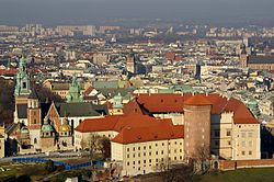 View of Wawel and Stare Miasto | |
 Dzielnica I Stare Miasto
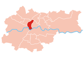
District Stare Miasto on the map of Kraków after the latest subdivisions | |
| Coordinates: 50°03′59.7″N 19°56′24.5″E / 50.066583°N 19.940139°ECoordinates: 50°03′59.7″N 19°56′24.5″E / 50.066583°N 19.940139°E | |
| Country | |
| Voivodeship | Lesser Poland |
| County/City | Kraków |
| Area | |
| • Total | 1.496 km2 (0.578 sq mi) |
| Population (31 December 2019) | |
| • Total | 30,609[1] |
| Time zone | UTC+1 (CET) |
| • Summer (DST) | UTC+2 (CEST) |
| Postal code | 31-151 |
| Area code(s) | +48 12 |
| Website | http://www.dzielnica1.krakow.pl/ |

Dzielnica I Stare Miasto (means "District 1 old town") is a district (Polish: dzielnica) of the city of Kraków, Poland. The first administrative district covers a wider area than the Old Town of Kraków itself.
Four out of nine subdivisions are forming UNESCO's World Heritage Site "Historic Centre of Kraków". Six subdivisions are part of the Historic Monument (pomnik historii) "Historical ensemble of the city of Kraków".
Location[]
The district is located in the centre part of Kraków, on the river Vistula to its south-west and south. To its north-west, the district borders the Prądnik Biały district (IV), to its north the district Prądnik Czerwony (III) and to its east the district Grzegórzki (II). Across the river it borders the district Podgórze (XIII) to its south and the district Dębniki (VIII) to its south-west. The district is bordered by Zwierzyniec (VII) and Krowodrza (V) to its west.
History[]
Kraków was the royal capital of Poland, until Sigismund III Vasa relocated the court to Warsaw in 1596. Kazimierz got town privileges in 1335, Kleparz in 1366. They were integrated in the town of Kraków between 1792 and 1795.
The current division with eighteen districts was introduced on 27 March 1991 and revised by Kraków City Council on 19 April 1995.
Kraków's historic centre was entered on the UNESCO list of World Heritage Sites in 1978. The Historic Monument "Historical ensemble of the city of Kraków" was declared by President Lech Wałęsa in 1994.
District subdivisions[]

The Roman numerals are indicating historical districts of Kraków which had been active between 1876 and 1954.
- Kazimierz VIII.
- Kleparz V.
- ("New Town")
- III. ("New World")
- IV.
- Stare Miasto or Śródmieście I. ("Old Town" or "city centre")
- VII.
- Warszawskie
- Wawel II.
UNESCO World Heritage Site and Historic Monument[]
Four subdivisions with 1.496 km2 (0.578 sq mi) are part of the World Heritage Site "Historic Centre of Kraków".
- Stare Miasto ("Old Town" with )
- Wawel Hill
- Stradom
- Kazimierz
The other subdivisions mentioned above are part of the buffer zone with exception of the modern part of Nowe Miasto.
The World Heritage Site and the subdivisions of Nowy Świat and Piasek are part of the Historic Monument (pomnik historii) "Historical ensemble of the city of Kraków" (Historyczny zespół miasta). A part of and the historic centre of Podgórze across the Vistula are completing the site. Historic monuments are objects of the highest level of objects of cultural heritage in Poland.
External links[]
| Wikimedia Commons has media related to District I Stare Miasto (Kraków). |
- Website of Dzielnica I Stare Miasto (Polish)
References[]
- ^ "Liczba mieszkańców w poszczególnych dzielnicach (wg. stanu na 31.12.2019) oraz powierzchnia dzielnic". www.bip.krakow.pl (in Polish). Retrieved 6 July 2020.

| Authority control: National libraries |
|---|
- Districts of Kraków