East Deboyne Islands
 | |
 East Deboyne Islands | |
| Geography | |
|---|---|
| Location | Oceania |
| Coordinates | 10°51′S 152°32′E / 10.850°S 152.533°ECoordinates: 10°51′S 152°32′E / 10.850°S 152.533°E[1] |
| Archipelago | Louisiade Archipelago |
| Adjacent bodies of water | Solomon Sea |
| Total islands | 8 |
| Major islands | |
| Area | 1.02 km2 (0.39 sq mi) |
| Highest elevation | 37 m (121 ft) |
| Highest point | Mount Pana Sagusagu |
| Administration | |
| Province | |
| District | Samarai-Murua District |
| LLG[2] | Louisiade Rural Local Level Government Area |
| Island Group | Deboyne Islands |
| Largest settlement | |
| Demographics | |
| Population | 0 (2014) |
| Pop. density | 0/km2 (0/sq mi) |
| Ethnic groups | Papauans, Austronesians, Melanesians. |
| Additional information | |
| Time zone | |
| ISO code | PG-MBA |
| Official website | www |
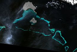
The East Deboyne Islands are a group of scattered island and reefs between the Deboyne Islands and the Renard Islands, in the north of the Louisiade Archipelago, Papua New Guinea. Panaeati Islanders have a Copra plantation on Mabui island.
Geography[]
They are located 10 km (6 mi) from Deboyne Islands .
History[]
The islands were discovered in 1793 by Antoine Bruni d'Entrecasteaux.
References[]
- Deboyne Island Information at the Wayback Machine (archived December 23, 2010)
This article about an island in Papua New Guinea is a stub. You can help Wikipedia by . |
Categories:
- Atolls of Papua New Guinea
- Archipelagoes of Papua New Guinea
- Islands of Milne Bay Province
- Louisiade Archipelago
- Papua New Guinea island stubs