Engayrac
Engayrac | |
|---|---|
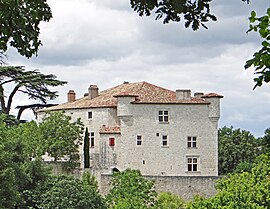 The château of la Combebonnet, in Engayrac | |
Location of Engayrac  | |
 Engayrac  Engayrac | |
| Coordinates: 44°15′37″N 0°53′11″E / 44.2603°N 0.8864°ECoordinates: 44°15′37″N 0°53′11″E / 44.2603°N 0.8864°E | |
| Country | France |
| Region | Nouvelle-Aquitaine |
| Department | Lot-et-Garonne |
| Arrondissement | Agen |
| Canton | Le Pays de Serres |
| Intercommunality | Porte d'Aquitaine en Pays de Serres |
| Government | |
| • Mayor (2020–2026) | Marie-France Salles[1] |
| Area 1 | 10.03 km2 (3.87 sq mi) |
| Population (Jan. 2018)[2] | 166 |
| • Density | 17/km2 (43/sq mi) |
| Time zone | UTC+01:00 (CET) |
| • Summer (DST) | UTC+02:00 (CEST) |
| INSEE/Postal code | 47087 /47470 |
| Elevation | 110–227 m (361–745 ft) (avg. 222 m or 728 ft) |
| 1 French Land Register data, which excludes lakes, ponds, glaciers > 1 km2 (0.386 sq mi or 247 acres) and river estuaries. | |
Engayrac is a commune in the Lot-et-Garonne department in south-western France.
See also[]
References[]
- ^ "Répertoire national des élus: les maires". data.gouv.fr, Plateforme ouverte des données publiques françaises (in French). 2 December 2020. Retrieved 7 December 2020.
- ^ "Populations légales 2018". INSEE. 28 December 2020.
| Wikimedia Commons has media related to Engayrac. |
This Lot-et-Garonne geographical article is a stub. You can help Wikipedia by . |
Categories:
- Communes of Lot-et-Garonne
- Lot-et-Garonne geography stubs