Montayral
Montayral | |
|---|---|
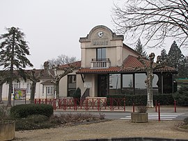 The town hall in Montayral | |
show Location of Montayral | |
 Montayral | |
| Coordinates: 44°28′49″N 0°59′17″E / 44.4803°N 0.9881°ECoordinates: 44°28′49″N 0°59′17″E / 44.4803°N 0.9881°E | |
| Country | France |
| Region | Nouvelle-Aquitaine |
| Department | Lot-et-Garonne |
| Arrondissement | Villeneuve-sur-Lot |
| Canton | Le Fumélois |
| Intercommunality | Fumel Vallée du Lot |
| Government | |
| • Mayor (2020–2026) | Jean-François Ségala[1] |
| Area 1 | 24.54 km2 (9.47 sq mi) |
| Population (Jan. 2018)[2] | 2,666 |
| • Density | 110/km2 (280/sq mi) |
| Time zone | UTC+01:00 (CET) |
| • Summer (DST) | UTC+02:00 (CEST) |
| INSEE/Postal code | 47185 /47500 |
| Elevation | 57–227 m (187–745 ft) (avg. 90 m or 300 ft) |
| 1 French Land Register data, which excludes lakes, ponds, glaciers > 1 km2 (0.386 sq mi or 247 acres) and river estuaries. | |


Montayral (French pronunciation: [mɔ̃teʁal]; Occitan: Montairal) is a commune in the Lot-et-Garonne department in south-western France.
See also[]
References[]
- ^ "Répertoire national des élus: les maires". data.gouv.fr, Plateforme ouverte des données publiques françaises (in French). 2 December 2020.
- ^ "Populations légales 2018". INSEE. 28 December 2020.
| Wikimedia Commons has media related to Montayral. |
This Lot-et-Garonne geographical article is a stub. You can help Wikipedia by . |
Categories:
- Communes of Lot-et-Garonne
- Lot-et-Garonne geography stubs