Eureka, Nevada
Eureka, Nevada | |
|---|---|
Unincorporated town & Census-designated places | |
 | |
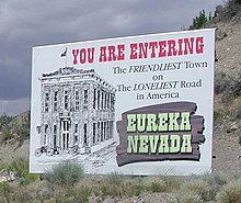
| Nickname(s): The Friendliest Town on The Loneliest Road in America | |
 Eureka Location in the state of Nevada | |
| Coordinates: 39°30′42″N 115°57′42″W / 39.51167°N 115.96167°WCoordinates: 39°30′42″N 115°57′42″W / 39.51167°N 115.96167°W | |
| Country | United States |
| State | Nevada |
| County | Eureka |
| Area | |
| • Total | 1.4 sq mi (3.6 km2) |
| • Land | 1.4 sq mi (3.6 km2) |
| • Water | 0.0 sq mi (0.0 km2) |
| Elevation | 6,485 ft (1,977 m) |
| Population (2010) | |
| • Total | 610 |
| • Density | 436/sq mi (168.3/km2) |
| Time zone | UTC−8 (Pacific (PST)) |
| • Summer (DST) | UTC−7 (PDT) |
| ZIP code | 89316 |
| FIPS code | 32-23900 |
| GNIS feature ID | 840384 |

Eureka is an unincorporated town and census-designated places in and the county seat of Eureka County, Nevada, United States.[1][2][3] With a population of 480 as of the 2018 American Community Survey 5-Year Estimates,[4] it is by far the largest community in Eureka County. Attractions include the Eureka Opera House (built in 1880 and restored in 1993), Raine’s Market and Wildlife Museum (built 1887), the Jackson House Hotel (built 1877), and the (housed in the 1879 Eureka Sentinel Newspaper Building).
Eureka is part of the Elko Micropolitan Statistical Area.
Geography and climate[]
Eureka is located at 39°30′42″N 115°57′42″W / 39.51159°N 115.961723°W,[5] in the southern part of Eureka County, at 6,481 feet (1,975 m) in the Diamond Mountains, in a draw on the southern end of Diamond Valley, between Antelope and Newark valleys. At the 2018 American Community Survey 5-Year Estimates, the population of the census-designated place of Eureka was 480,[4] while the total population of Eureka and the surrounding area (Eureka CCD, Eureka County, Nevada) was 1,313.[6]
The town is located along the Lincoln Highway / U.S. Route 50, nicknamed "The Loneliest Road in America": aptly named, as the nearest towns along the highway are Austin (70 mi or 110 km west) and Ely (77 mi or 124 km east). The nearest town is Duckwater, 46 mi (74 km) south.
The climate is typical of the Great Basin: hot and dry with cool mornings in the summer with occasional monsoonal thunderstorms from late July through August; cold and relatively dry in the winter. Temperatures drop to 0 °F or −17.8 °C or lower on an average 4.7 mornings during the winter, though in the severe winter of 1916/1917 this happened twenty-five times. They drop to 32 °F or 0 °C on an average 181.3 mornings, though maximum temperatures top freezing on all but 26.3 days during an average winter. During the summer temperatures rise to 90 °F or 32.2 °C or hotter on 11.8 afternoons, though 100 °F or 37.8 °C has never been reached with the hottest temperature being 99 °F or 37.2 °C on July 14, 1955. Snow accumulations vary from 10 to 30 inches (0.25 to 0.76 m) in mild winters to in excess of 80 inches (2.03 m) in more severe years; in the winter of 1906/1907, more than 150 inches or 3.81 metres of snow fell.
The wettest calendar year has been 1941 with 23.86 inches (606.0 mm) and the driest 2008 with 5.64 inches (143.3 mm), whilst May 1917 with 5.73 inches (145.5 mm) has been the wettest single month. The snowiest month has been March 1902 with 54.0 inches or 1.37 metres of fresh snowfall.
Under the Köppen climate classification, Eureka has a warm-summer humid continental climate (Dfb).
| hideClimate data for Eureka, Nevada (Elevation 6,500 feet or 2,000 metres); 1971-2000 | |||||||||||||
|---|---|---|---|---|---|---|---|---|---|---|---|---|---|
| Month | Jan | Feb | Mar | Apr | May | Jun | Jul | Aug | Sep | Oct | Nov | Dec | Year |
| Record high °F (°C) | 61 (16) |
65 (18) |
75 (24) |
81 (27) |
91 (33) |
95 (35) |
98 (37) |
97 (36) |
90 (32) |
86 (30) |
72 (22) |
63 (17) |
98 (37) |
| Average high °F (°C) | 36.9 (2.7) |
40.7 (4.8) |
46.9 (8.3) |
54.9 (12.7) |
64.5 (18.1) |
75.8 (24.3) |
84.5 (29.2) |
82.6 (28.1) |
73.5 (23.1) |
61.3 (16.3) |
46.0 (7.8) |
38.1 (3.4) |
58.8 (14.9) |
| Average low °F (°C) | 16.3 (−8.7) |
19.3 (−7.1) |
24.0 (−4.4) |
28.8 (−1.8) |
36.5 (2.5) |
44.6 (7.0) |
52.4 (11.3) |
51.6 (10.9) |
43.7 (6.5) |
33.6 (0.9) |
23.4 (−4.8) |
16.7 (−8.5) |
32.6 (0.3) |
| Record low °F (°C) | −26 (−32) |
−23 (−31) |
−9 (−23) |
5 (−15) |
10 (−12) |
11 (−12) |
29 (−2) |
30 (−1) |
5 (−15) |
3 (−16) |
−11 (−24) |
−21 (−29) |
−26 (−32) |
| Average precipitation inches (mm) | 1.00 (25) |
0.91 (23) |
1.45 (37) |
1.16 (29) |
1.54 (39) |
0.74 (19) |
0.55 (14) |
0.83 (21) |
1.00 (25) |
1.05 (27) |
0.95 (24) |
0.88 (22) |
12.06 (305) |
| Average snowfall inches (cm) | 12.7 (32) |
6.9 (18) |
11.4 (29) |
6.6 (17) |
4.0 (10) |
0.1 (0.25) |
0.0 (0.0) |
0.0 (0.0) |
0.7 (1.8) |
2.0 (5.1) |
7.3 (19) |
9.4 (24) |
61.1 (156.15) |
| Average precipitation days (≥ 0.01 inch) | 5.9 | 5.3 | 7.6 | 5.9 | 6.2 | 4.2 | 3.3 | 3.9 | 3.8 | 4.5 | 4.7 | 5.6 | 60.9 |
| Average snowy days (≥ 0.1 inch) | 5.2 | 3.8 | 4.7 | 2.6 | 1.2 | 0.1 | 0.0 | 0.0 | 0.2 | 1.0 | 2.7 | 4.4 | 25.9 |
| Source 1: National Oceanic and Atmospheric Administration[7] | |||||||||||||
| Source 2: National Weather Service, Elko, Nevada[8] | |||||||||||||
History[]


The town was first settled in 1864 by a group of silver prospectors from nearby Austin, who discovered rock containing a silver-lead ore on nearby Prospect Peak. According to tradition, the town was named from an incident when a prospector exclaimed "Eureka!" when he discovered deposits of silver ore.[9] The town became the county seat in 1873, when Eureka County was carved out of adjacent Lander, Elko, and White Pine counties.
Mining, especially for lead, was the town's economic mainstay,[10] as the nearby hillsides ranked as Nevada's second-richest mineral producer, behind western Nevada's Comstock Lode. Two of the largest concerns in Eureka were the Richmond Mining Company and the Eureka Mining Company. These two companies often collided, and in one instance, their litigation reached the U.S Supreme Court.[11] The population boomed, reaching a high of 10,000 by 1878, but shrank as decreasing mine production and changing market conditions led to the closing of mines.
The town was serviced by the narrow gauge Eureka and Palisade Railroad from 1873 to 1938.
Public services[]
Eureka is served by an all-volunteer fire department, which provides fire protection, rescue, and vehicle rescue services for Eureka and the surrounding areas. In 2009 a new brick and steel fire house was built on Main Street in Eureka. At the time of its building it was the second largest fire house in the state. In addition to being a modern fire fighting facility, it contains a museum of Eureka fire department equipment and vehicles dating back to the 1870s. The fire-museum may be viewed through the large glass windows, or a tour may be taken by contacting a local fireman.
Eureka boasts three parks, a modern enclosed swimming facility, two baseball fields, a track, and football field.
The 1880s Eureka Opera House was re-modeled in recent times and regularly schedules performers.[12]
The 1876 Eureka Court House is both historic and modern. It stands as the functioning governmental and legal center of Eureka County.
Celebrations[]
July 4, Independence Day, is a huge celebration in Eureka. The Eureka Volunteer Fire Department organizes a parade followed by street events, which require closing central Eureka to vehicular traffic. At 9pm the Eureka Volunteer Fire Department stages a fireworks display.
Education[]
Eureka has a public library, a branch of the Elko-Lander-Eureka County Library System.[13]
Transportation[]
Notable people[]
- John Cradlebaugh, first delegate to the U.S. House of Representatives from Nevada Territory[14]
- Warren J. Ferguson, who served on the United States Court of Appeals for the Ninth Circuit
- Antonio Mendez, CIA operative, who orchestrated the smuggling of six US hostages out of Iran. The Academy Award-winning film Argo was based on the experience. Mendez was born in Eureka.
Gallery[]

Entering Eureka 1991
Welcome

A view of Eureka

Parade 2006

Ore chutes in 1871

Eureka Consolidated smelter, ca. 1880


References[]
- ^ "Eureka County Code - Title 12- Town of Eureka" (PDF). Eureka County. Retrieved 2017-10-16.
- ^ "Find a County". National Association of Counties. Archived from the original on 2011-05-31. Retrieved 2011-06-07.
- ^ Lambert Molinelli & Co (1982). Eureka and its resources: a complete history of Eureka County, Nevada, containing the United States mining laws, the mining laws of the district, bullion product and other statistics for 1878, and a list of county officers. Reno, Nev.: University of Nevada Press. ISBN 978-0-87417-069-6. LCCN 82004948. OCLC 8346713. Reprint. Originally published: San Francisco : H. Keller, 1879.
- ^ Jump up to: a b "Census Geography Profile". U.S. Census Bureau. Retrieved April 10, 2020.
- ^ "US Gazetteer files: 2010, 2000, and 1990". United States Census Bureau. 2011-02-12. Retrieved 2011-04-23.
- ^ "Census Search result". U.S. Census Bureau. Retrieved April 10, 2020.
- ^ "Climatography of the United States No. 20: 1971-2000" (PDF). National Oceanic and Atmospheric Administration. Retrieved November 20, 2016.
- ^ "National Weather Service Forecast Office, Elko, NV". National Weather Service. Retrieved November 20, 2016.
- ^ Federal Writers' Project (1941). Origin of Place Names: Nevada (PDF). W.P.A. p. 34.
- ^ "Eureka, Nevada". Western Mining History. Retrieved 2012-03-18.
- ^ "Richmond Mining Co. v. Eureka Mining Co., 103 U.S. 839 (1880)". Justia Law. Retrieved 2021-09-09.
- ^ "Eureka Opera House". Eureka County, Nevada -- Official Home Page. Retrieved 2012-03-18.
- ^ "Nevada Public Libraries". PublicLibraries.com. Retrieved 14 June 2019.
- ^ Biographical Directory of the United States Congress
External links[]
| Wikimedia Commons has media related to Eureka, Nevada. |
- Website for the town of Eureka, Nevada
- JB Monaco Eureka Photo Gallery
- Eureka Self-Guiding Tour; link contains many modern and historical photographs of existing buildings, and historical tales of the area
- Areddy, James T. (2012-12-28). "In Nevada, a Chinese King of the Hill". Wall Street Journal. ISSN 0099-9660. Retrieved 2021-09-09. $1.3 billion plan for moly mine at Mt. Hope
| show Municipalities and communities of Eureka County, Nevada, United States |
|---|
| show Authority control |
|---|
- Census-designated places in Nevada
- Census-designated places in Eureka County, Nevada
- County seats in Nevada
- Populated places established in 1864
- Elko, Nevada micropolitan area
- Unincorporated towns in Nevada
- 1864 establishments in Nevada
- Silver mining in Nevada